France’s countryside presents an extraordinary tapestry of landscapes that has captivated visitors for centuries. From the sun-drenched hillsides of Provence dotted with ancient stone villages to the rolling vineyards of Burgundy and the dramatic cliffs of Normandy, each region offers distinct geographical features and cultural heritage. The diversity spans Mediterranean coastal plains, alpine meadows, river valleys carved through limestone plateaus, and bocage landscapes shaped by centuries of agricultural tradition.
Understanding the geological foundations and cultural evolution of these regions enhances appreciation of their visual appeal. Many landscapes reflect millennia of human interaction with natural topography, creating the harmonious blend of wilderness and cultivation that defines French terroir. Whether seeking the geometric precision of lavender fields, the organic curves of vineyard terraces, or the architectural heritage of medieval villages, France’s countryside regions provide unparalleled opportunities for landscape photography and cultural exploration.
Provence-alpes-côte d’azur: mediterranean terraced vineyards and lavender field topography
The Provence-Alpes-Côte d’Azur region exemplifies Mediterranean landscape architecture, where centuries of agricultural adaptation have shaped terrain into distinctive geometric patterns. The region’s limestone foundation, formed during the Jurassic period, creates the characteristic white and ochre cliffs that define many village locations. This geological base provides excellent drainage for viticulture whilst creating the dramatic relief that makes hilltop settlements both practical and visually striking.
Seasonal variations dramatically transform the visual character of Provençal landscapes. Spring brings wildflower carpets across hillsides, whilst summer intensifies the contrast between silvery olive groves and deep purple lavender fields. Autumn harvests reveal the underlying geometric structure of vineyard terraces, and winter’s reduced vegetation exposes the architectural bones of stone villages and terraced cultivation systems.
Luberon natural regional park’s ochre cliff formations and stone village architecture
The Luberon’s distinctive ochre deposits create landscapes unique in Europe, ranging from pale yellow to deep red depending on iron oxide concentration. These pigments, quarried since Roman times, have supplied building materials that seamlessly integrate villages into their geological context. The ochre cliffs of Roussillon and surrounding areas demonstrate how mineral composition directly influences architectural colour palettes and structural techniques.
Stone extraction and processing techniques developed over centuries have created both the raw materials for village construction and the quarried landscapes that add visual drama to the region. Traditional building methods utilise local limestone combined with ochre-rich mortars, creating structures that appear to emerge naturally from the landscape. Modern conservation efforts maintain these traditional techniques whilst protecting the geological formations from excessive extraction.
Valensole plateau’s geometric lavender cultivation patterns and seasonal colour transitions
The Valensole Plateau demonstrates agricultural geometry on a landscape scale, where lavender cultivation creates precisely ordered patterns across rolling terrain. Planted in rows following contour lines, lavender fields reveal the subtle topography whilst creating striking visual rhythms. The spacing between rows, determined by harvesting machinery requirements, generates distinctive linear patterns visible from elevated viewpoints throughout the region.
Bloom timing varies with elevation and microclimate, creating a progressive wave of colour across the plateau from late June through August. Early morning and late afternoon lighting enhances the contrast between purple lavender, golden wheat fields, and pale limestone outcrops. Professional landscape photographers often time visits to coincide with peak bloom periods, when colour saturation reaches maximum intensity before harvest begins.
Gordes and roussillon: perched village photography techniques for golden hour captures
Perched villages like Gordes and Roussillon present unique photographic challenges due to their clifftop positions and stone construction materials that reflect available light differently throughout the day. Golden hour illumination, occurring approximately one hour before sunset, provides optimal conditions for capturing the warm tones of limestone and ochre architecture against darker valley backgrounds.
Viewpoint selection requires understanding of seasonal sun angles and shadow patterns cast by terrain features. Higher elevation positions often provide better separation between village silhouettes and background landscapes, whilst closer approaches allow detailed documentation of architectural elements and traditional construction techniques. Weather conditions significantly influence light quality, with partially cloudy skies often producing more dramatic illumination than completely clear
skies, which act like a giant softbox and diffuse the Mediterranean light across façades and surrounding terraces.
For countryside photography enthusiasts, tripod stability and careful exposure management are essential when shooting from viewpoints above Gordes or along the ochre paths of Roussillon. Long focal lengths help compress distance and emphasise the stacked stone houses climbing the hillside, while wide-angle lenses capture the full interplay between village, cultivated terraces, and distant mountain ridgelines. In summer, arriving 60–90 minutes before sunset allows time to scout compositions and observe how the warm Provençal light slowly sculpts the stonework and surrounding landscape.
Camargue delta wetland ecosystems and pink flamingo migration corridors
Further south, the Camargue delta introduces a very different countryside landscape, defined by brackish lagoons, reed beds, and shifting sandbars where the Rhône meets the Mediterranean. This low-lying wetland complex acts as a natural buffer between land and sea, its mosaic of étangs (shallow lakes), salt pans, and marshes constantly reshaped by river flow, tides, and wind. The flat topography and reflective water surfaces create expansive horizons, a striking contrast to the terraced vineyards and limestone ridges that dominate much of Provence.
The Camargue is one of Europe’s most important migration corridors for wading birds, particularly the greater flamingo. Seasonal water level management by conservation authorities maintains feeding areas rich in brine shrimp and other invertebrates, which in turn sustain large flamingo colonies from spring through autumn. For visitors, dawn and dusk are the best times to observe these birds in flight, when low-angle light turns both plumage and saline lagoons soft shades of pink and gold.
From a photographic and ecological perspective, understanding the dynamic relationship between water salinity, vegetation zones, and bird behaviour helps you anticipate where to position yourself. Elevated hides and discreet roadside pull-offs around the Étang de Vaccarès and nearby reserves provide vantage points that minimise disturbance. Long lenses (300 mm and beyond) allow you to frame flamingos against minimalist horizons, while polarising filters help control glare on open water and bring out subtle gradations of colour in the sky and marsh.
Burgundy wine route: côte d’or vineyard terroir and medieval village preservation
The Burgundy countryside, particularly along the Côte d’Or, offers one of the most finely grained expressions of agricultural landscape in France. Here, centuries of observation and monastic record-keeping have mapped minute variations in slope, soil, and drainage into an intricate patchwork of vineyard parcels, or climats, many of which are now UNESCO listed. Narrow roads wind between low stone walls and dry-stone cabottes (field shelters), linking working vineyards with remarkably well-preserved medieval towns and villages.
Unlike more dramatic alpine or coastal scenery, Burgundy’s beauty lies in nuance: subtle shifts in vine canopy colour between appellations, the gentle convex profiles of limestone escarpments, and the way church spires anchor villages at the edge of cultivated slopes. For countryside explorers, walking or cycling segments of the Route des Grands Crus between Beaune and Dijon allows you to experience how topography, geology, and human settlement interlock over short distances. Autumn, when vine leaves transition through yellow, orange, and deep red, is particularly photogenic.
Beaune to dijon escarpment geology and appellation boundary demarcations
The Côte de Beaune and Côte de Nuits form a continuous limestone escarpment, gently tilted towards the Saône plain. This geologic structure, originating in the Jurassic era, creates an ideal sequence of mid-slope exposures where water drains freely yet sufficient moisture is retained in fractured rock and thin clay-limestone soils. Appellation boundaries often follow slight breaks in slope, subtle changes in rock type, or variations in the depth of colluvial deposits at the base of the coteaux.
As you travel north from Beaune to Dijon, you can see how premier and grand cru parcels occupy the mid-slope belts, with village-level vineyards above and below. Dry-stone walls, narrow access tracks, and occasional tree lines mark these transitions in the landscape, acting as both practical boundaries and visual cues to underlying terroir differences. In many places, exposed rock faces and old quarry sites provide direct views into the stratigraphy that underpins the famous vineyard names printed on labels.
For those mapping countryside itineraries, combining geological maps or simple topographic profiles with vineyard walks deepens your understanding of why certain sites have been prized for centuries. Looking up from the flatter land near the N74 road towards the escarpment, you can trace how each band of vines steps up the slope, much like the seating tiers of an amphitheatre overlooking the plain. This amphitheatre analogy is particularly useful when planning photography, as it highlights how light moves across the “stage” of vineyards during the day.
Chablis kimmeridgian soil composition and vine training systems
Further north, the Chablis region presents a cooler, more open countryside, where rolling hills of Kimmeridgian marl create a distinct visual and viticultural identity. These soils, rich in fossilised marine organisms, especially small oysters, crumble easily and form pale, crumbly slopes that reflect light back into the vine canopy. This reflective quality, combined with the region’s continental climate, contributes to the high acidity and mineral structure associated with classic Chablis wines.
In the vineyards surrounding the town of Chablis and neighbouring villages, most vines are trained using variations of Guyot systems, with one or two fruiting canes tied along low wires. From a distance, these parallel lines of cordons create ordered textures that emphasise the contours of each hillside. Frost protection measures, such as wind machines or, in some parcels, heaters and sprinklers, also leave subtle marks on the landscape, especially in early spring when protective smoke or ice can momentarily transform the appearance of the vines.
When exploring this part of Burgundy’s countryside, look for viewpoints where the patchwork of Chablis, Premier Cru, and Grand Cru parcels can be read like a topographic diagram. South and south-west facing slopes above the Serein River form natural amphitheatres that catch the sun, while cooler, more exposed plateaux support cereal cultivation and woodland. Photographing in early morning mist or after autumn rain can enhance the chalky luminosity of the soils and accentuate the contrast between vine rows and surrounding hedgerows.
Château du clos de vougeot: cistercian monastic agricultural heritage
At the heart of the Côte de Nuits, the walled vineyard of Clos de Vougeot encapsulates Burgundy’s fusion of rural architecture, monastic heritage, and meticulous land division. Originally established by Cistercian monks in the 12th century, the clos still preserves its stone boundaries, historic cellar buildings, and gravity-fed wine presses, all arranged within a single, gently sloping parcel. The château itself, added later, rises modestly above the vines, its massing carefully balanced with surrounding agricultural structures.
The layout of Clos de Vougeot illustrates how monastic communities shaped the countryside by integrating spiritual, residential, and productive spaces within a coherent enclosure. Inside the walls, subtle changes in elevation and drainage guided early decisions on where to plant vines, position buildings, and route access paths. Outside, the clos sits within a wider matrix of individual parcels, each now owned by different producers but still aligned along the same slope, reinforcing a sense of historical continuity in the landscape.
Visitors walking the perimeter paths can observe how the thickness and construction style of the walls vary with terrain, a reminder that these boundaries were engineered as much for practical purposes—livestock exclusion, wind deflection—as for symbolic enclosure. For photographers, slightly elevated angles from the upper side of the clos allow you to capture the château framed by vines, with the wider Côte d’Or escarpment in the background. Early autumn, when leaves begin to change but the canopy remains full, offers particularly rich colour gradients across the enclosed vineyard.
Nuits-saint-georges premier cru classification and slope orientation analysis
Around Nuits-Saint-Georges, the interplay between slope orientation, elevation, and soil depth becomes especially clear to the eye. Premier cru sites typically occupy east to south-east facing mid-slopes between roughly 240 and 300 metres altitude, benefiting from morning sun, moderated afternoon heat, and efficient cold air drainage at night. In contrast, village-level parcels may extend further up-slope onto thinner, rockier ground, or down-slope towards deeper alluvial deposits closer to the plain.
Walking or driving the small roads that climb out of Nuits-Saint-Georges towards the Combe des Vallerots reveals how quickly these conditions shift over a few hundred metres. South-facing sectors feel noticeably warmer and drier in summer, with shorter grass cover and more exposed stones between vine rows, while north-east facing corners retain moisture longer and often support a denser understorey. These micro-variations, carefully documented over generations, underpin the premier cru classifications that appear on maps and labels.
For countryside explorers interested in both wine and landscape analysis, bringing a simple compass or using a smartphone inclinometer can turn a vineyard walk into a practical study of orientation and gradient. Ask yourself: how does the view change as you move around a hill, and where does the sun sit relative to the vines at different times of day? Photographing the same parcel in morning and late-afternoon light can reveal how slope orientation not only shapes grape ripening, but also the character of your images—shadows lengthen, textures pop, and the patterned rows read more strongly across the frame.
Loire valley châteaux corridor: renaissance garden design and river meander patterns
The Loire Valley countryside stretches along France’s last great wild river, where châteaux, market towns, and small farming hamlets line broad alluvial plains and wooded slopes. Unlike the more tightly framed vineyard landscapes of Burgundy, here the horizon opens out, with the river’s wide meanders carving sweeping curves through sandbanks, islands, and riparian forests. Many of the most famous châteaux—Chambord, Chenonceau, Amboise—are positioned either directly on the riverbank or within visual reach, using the waterway as both a practical transport route and a compositional anchor.
Renaissance garden design in the Loire took full advantage of this setting, aligning formal parterres, canals, and terraces with both the main château façades and the natural flow of the river. At Villandry, geometric boxwood patterns echo the rectilinear layout of irrigation channels, while at Chenonceau the long gallery physically bridges the Cher River, creating one of Europe’s most striking integrations of architecture and landscape. From elevated points—hillside villages, castle towers, or even modern hot-air balloon flights—you can read the relationship between human-imposed order in the gardens and the more organic, shifting patterns of the river beyond.
Understanding the hydrology of the Loire and its tributaries helps explain why certain stretches host clusters of châteaux while others remain more sparsely developed. Historical floodplains limited permanent construction in low-lying zones, pushing settlements slightly up the valley sides where bedrock offered stable foundations. Contemporary visitors can still trace old levees, back channels, and oxbow lakes in the countryside, particularly visible in aerial imagery or from high vantage points. For photographers and walkers alike, early morning mist rising from the river in spring and autumn adds an ephemeral layer, softening the lines between gardens, fields, and forested hills.
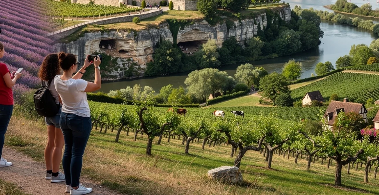
Dordogne périgord: limestone karst topography and troglodyte cliff dwellings
In southwestern France, the Dordogne (Périgord) region offers some of the country’s most evocative countryside, where river valleys cut deep into limestone plateaus and medieval villages cling to cliffs above meandering water. The underlying karst topography—characterised by caves, sinkholes, and sheer rock faces—has shaped both natural scenery and human settlement patterns for tens of thousands of years. Prehistoric cave sites such as Lascaux, along with numerous shelters and fortified cliff dwellings, testify to a long dialogue between people and stone.
Villages like La Roque-Gageac and Beynac-et-Cazenac appear almost sculpted from the cliffs themselves, with ochre houses stacked in tiers above the river and narrow lanes climbing steeply between rock and rooftop. Many troglodyte sites began as simple rock shelters before being expanded into multi-level habitations, storehouses, and defensive refuges, taking advantage of natural overhangs and ledges. From a distance, these human-made cavities and extensions read as small dark rectangles punctuating otherwise continuous limestone walls, an effect particularly visible in low, raking light.
For countryside travellers, exploring the Dordogne by canoe or kayak offers a revealing perspective on this vertical dimension, as you glide beneath overhanging cliffs and look up to see castles, villages, and abandoned cave complexes nested above. On land, hilltop lookouts and château terraces grant panoramic views over looping river bends, patchworked fields, and mixed deciduous forest. The region’s karst systems also support rich biodiversity, with cool, moist microclimates in caves and north-facing slopes contrasting with sun-baked south-facing escarpments and open plateaux used for walnut groves and pasture.
Normandy bocage landscape: hedgerow field systems and cider apple orchards
Normandy’s inland countryside is defined less by dramatic relief and more by an intimate, enclosed pattern of fields, hedgerows, and small woodlots collectively known as bocage. This traditional field system, developed over centuries, uses dense earth banks topped with shrubs and trees to divide pastures and arable plots, providing shelter for livestock, controlling soil erosion, and creating a highly biodiverse network of linear habitats. From above, bocage appears as a fine-grained mosaic of irregular shapes, quite different from the large open fields seen in more intensively farmed regions.
Within this framework, cider apple orchards add another layer of character to the Normandy landscape. High-stem and low-stem trees scatter across meadows or align in more formal grids, their spring blossom transforming pastures into pale pink and white carpets. In autumn, fallen fruit beneath the trees and stacked wooden crates by farm tracks hint at the seasonal cycle of cider and calvados production that remains central to local identity. Many farms now welcome visitors for tastings and short tours, offering a direct connection between the landscape you see and the beverages you sample.
For those exploring by car, bicycle, or on foot, the bocage can feel like a countryside labyrinth, with narrow, sunken lanes winding between high banks and overarched by tree canopies. While this limits long-distance views, it enhances the sense of discovery: each bend reveals a new combination of orchard, stone farmhouse, and church spire. From occasional hilltops or breaks in the hedgerows, you can appreciate how these small fields step gently down towards rivers and coastal marshes, linking inland dairy and apple country with the sea-facing cliffs and beaches that form Normandy’s more widely known scenery.
Alsace route des vins: half-timbered architecture and rhine valley microclimate zones
On France’s eastern flank, the Alsace wine route threads through a chain of villages nestled between the Vosges foothills and the Rhine plain. Here the countryside feels particularly intimate, with vineyards rising steeply behind half-timbered houses painted in pastel tones and trimmed with flower boxes. The contrast between the wooded crest line of the Vosges and the open, flat expanse of the Rhine valley creates a marked rain shadow effect, giving Alsace one of the driest microclimates in France despite its northern latitude.
This combination of shelter and sunshine allows vines to thrive on slopes reaching 300–400 metres, often terraced or carefully contoured to follow the natural lines of the hills. Granite, sandstone, limestone, and volcanic substrates alternate over short distances, and you can frequently see these shifts in the colour and texture of soils exposed at path edges or low retaining walls. Appellation maps for Alsace highlight how grand cru parcels occupy the best-exposed, well-drained sectors, their boundaries sometimes coinciding with changes in geology, aspect, or historical ownership patterns.
Within the villages themselves—places like Riquewihr, Eguisheim, and Kaysersberg—traditional half-timbered architecture anchors the human scale of the landscape. Overhanging upper stories, carved beams, and internal courtyards reflect medieval urban design adapted to narrow footprints and defensive needs. From surrounding vineyard paths, these clustered settlements appear as tight, colourful islands at the base of the slopes, often centred on a church tower that acts as a landmark for orientation across the valley.
For countryside travellers and photographers, the interplay of microclimate, architecture, and topography makes Alsace particularly rewarding in shoulder seasons. Autumn brings warm, hazy light over ripening Riesling and Gewürztraminer grapes, while winter mists descending from the Vosges can partially veil villages, leaving only rooftops and steeples emerging above the fog. Whether you are tracing contour-hugging trails between grand cru sites or simply pausing in a village square beneath half-timbered façades, you are constantly reminded of how closely climate, landform, and human craftsmanship are woven together in this corner of France.