The South Pacific represents one of Earth’s most spectacular cruising destinations, offering an unparalleled collection of remote islands, pristine atolls, and culturally rich archipelagos scattered across vast ocean expanses. From the dramatic volcanic landscapes of French Polynesia to the vibrant coral gardens of New Caledonia, each island group presents unique opportunities for exploration and discovery. Modern expedition cruising has transformed access to these previously unreachable destinations, allowing travellers to experience authentic Polynesian culture whilst enjoying sophisticated onboard amenities. The region’s diverse geography encompasses everything from towering volcanic peaks and cascading waterfalls to shallow lagoons perfect for snorkelling and traditional navigation techniques still practised by indigenous communities today.
French polynesia’s marquesas islands: remote archipelago navigation
The Marquesas Islands represent the most remote inhabited archipelago in French Polynesia, situated approximately 1,400 kilometres northeast of Tahiti. These rugged volcanic islands offer expedition cruisers access to some of Polynesia’s most authentic cultural experiences, where ancient traditions remain largely unchanged by modern tourism. The challenging navigation conditions and limited infrastructure have preserved the Marquesas’ wild character, making them particularly appealing for adventurous travellers seeking genuine cultural immersion.
The archipelago consists of twelve islands, with six inhabited, each offering distinct geological formations and cultural heritage sites. Trade winds and strong ocean swells characterise the region, requiring experienced captains and specialised vessels equipped for remote area operations. The absence of protective coral reefs means anchorages are typically exposed, demanding careful weather monitoring and flexible itineraries. Limited fuel and provisioning facilities necessitate comprehensive preparation and self-sufficiency for extended stays.
Nuku hiva’s taiohae bay anchorage points and marine infrastructure
Taiohae Bay serves as the administrative capital of the Marquesas and provides the archipelago’s most reliable anchorage facilities. The horseshoe-shaped bay offers excellent protection from easterly trade winds, with depths ranging from 15 to 30 metres over sandy and coral substrate. Modern cruise vessels typically anchor in the bay’s northern section, where holding is secure and tender operations can proceed safely even in moderate swells.
The bay features basic marine infrastructure including a small dock suitable for expedition tenders and local supply boats. Fuel and fresh water are available through local agents, though quantities may be limited during peak cruising seasons. The settlement provides essential services including basic medical facilities, postal services, and limited provisioning opportunities. Radio communications operate on standard marine frequencies, with cellular coverage available near the main village.
Hiva oa’s atuona port facilities and paul gauguin cultural sites
Atuona Bay on Hiva Oa offers an alternative anchorage with historical significance as the final resting place of artist Paul Gauguin and Belgian singer Jacques Brel. The bay provides adequate shelter during typical trade wind conditions, though the anchorage can become uncomfortable during periods of southerly swells. Depths range from 12 to 25 metres, with good holding in sand and coral patches.
The village maintains a small wharf suitable for tender operations during calm conditions. Cultural attractions include the Gauguin Museum and Jacques Brel Centre, both easily accessible from the landing area. Traditional stone platforms (me’ae) and archaeological sites throughout the island offer insights into ancient Marquesan civilisation. Local guides provide essential context for understanding the complex cultural landscape and traditional land management practices still practised today.
Ua pou’s volcanic spire formations and traditional polynesian villages
Ua Pou distinguishes itself through dramatic basaltic spires rising directly from the ocean, creating one of the Pacific’s most striking geological displays. Hakahau Bay provides the primary anchorage, though its narrow entrance and coral heads require careful navigation during entry. The bay offers good protection from easterly trades but remains exposed to northerly swells during winter months.
Traditional villages scattered throughout Ua Pou maintain authentic Polynesian lifestyles, with residents practising ancient handicrafts including intricate woodcarving and traditional tattooing techniques. The island’s isolation has preserved unique dialects and cultural practices rarely encountered elsewhere in French Polynesia. Hiking trails lead to spectacular viewpoints overlooking
the island’s signature spires and coastal valleys, with several routes suitable for guided shore excursions. For visiting vessels, engaging local pilots or experienced guides is strongly recommended, particularly for first-time entries into Hakahau Bay or secondary anchorages along the coast. Respect for village protocols, including dress standards and gift-giving customs, remains an important aspect of responsible cruising in this part of the South Pacific.
Fatu hiva’s hanavave bay protected mooring systems
Fatu Hiva is often regarded as one of the most visually dramatic islands in the Marquesas, and Hanavave Bay—also known as the Bay of Virgins—is its most iconic anchorage. Steep basalt cliffs and lush valleys encircle the bay, creating a natural amphitheatre that provides partial protection from prevailing winds. However, the absence of a fringing reef and the bay’s relatively limited swinging room mean that anchoring must be undertaken with particular care, especially for larger expedition cruise ships and superyachts.
In recent years, local authorities and yachting associations have worked together to establish designated mooring systems and recommended anchoring zones within Hanavave Bay. These protected mooring points help to minimise damage to the seabed and sensitive benthic habitats, while also improving safety for visiting vessels during sudden wind shifts or swell events. Captains are encouraged to liaise with village representatives upon arrival to confirm available moorings, obtain up-to-date information on bay conditions, and coordinate tender operations to the small landing area at the head of the bay.
Shore excursions from Hanavave typically focus on hiking into the interior valleys, visiting traditional craft workshops, and experiencing village hospitality. Residents of Fatu Hiva are renowned for tapa cloth production and skilled woodcarving, with opportunities for visitors to purchase locally made handicrafts that directly support the community. Due to the island’s isolation and lack of formal port infrastructure, provisioning options are extremely limited; expedition cruise operators generally treat Fatu Hiva as a scenic and cultural highlight rather than a logistical resupply point.
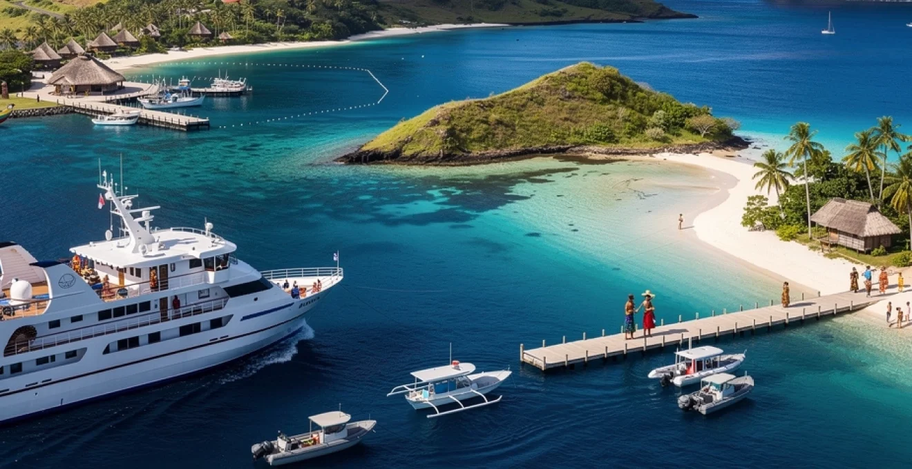
Fiji’s outer island cruise circuits: yasawa and mamanuca archipelagos
West of Fiji’s main island of Viti Levu, the Yasawa and Mamanuca archipelagos form one of the South Pacific’s most popular cruising corridors. These chains of volcanic and coral islands offer sheltered anchorages, clear lagoons, and a mix of traditional villages and world-class resorts, making them ideal for both small expedition vessels and larger cruise ships operating with tender support. The relatively short distances between islands allow flexible itineraries, enabling operators to adapt to changing weather while still delivering a diverse range of shore experiences.
For travellers, cruising through the Yasawas and Mamanucas provides access to secluded beaches, vibrant coral reefs, and authentic cultural encounters that are often impossible to experience on a land-based holiday alone. Many resorts maintain cooperative agreements with cruise lines, allowing guests to disembark for day use of facilities, spa treatments, and guided activities such as diving or kayaking. At the same time, several island communities have established structured village visit programmes that provide income while preserving local customs and traditions.
Blue lagoon cruises’ exclusive anchorage permissions in sacred waters
Among the most established operators in western Fiji, Blue Lagoon Cruises has developed long-term relationships with local landowning clans across the Yasawa Islands. These partnerships grant the company exclusive or preferential access to certain anchorages and beaches, including areas considered culturally significant or tabu (sacred). For guests, this translates into quieter bays, carefully managed visitor numbers, and opportunities to experience village life in a respectful, organised way.
The company’s itineraries are designed around sheltered anchorages that allow comfortable overnight stays, typically in depths of 10 to 20 metres with sand bottoms and good holding. Because many of these bays are within traditional fishing grounds, Blue Lagoon Cruises works with village elders to schedule visits, manage reef use, and support local conservation initiatives. As a guest, you may be invited to participate in a sevusevu ceremony—where the ship’s representative presents kava to the chief—formalising permission to enter village lands and nearby waters.
From a practical standpoint, cruisers following similar routes should be prepared to obtain permission before anchoring in lesser-known bays, even when no formal infrastructure is present. Advanced communication via local agents or resort contacts can help ensure that your presence is welcomed and that anchorages are used in ways that align with community expectations. In many cases, small landing fees or contributions to village funds are requested, providing a sustainable model for tourism in these remote Fijian islands.
Malolo island’s resort integration with luxury expedition vessels
Malolo Island, situated in the Mamanuca group, has become a key hub for integrating resort amenities with luxury expedition cruising. Surrounded by fringing reefs and shallow lagoons, Malolo offers multiple anchorage options in 8 to 18 metres of water, typically protected from the prevailing southeast trade winds. Larger vessels often anchor off the western side of the island, where tender routes to resort jetties are straightforward and well-marked.
A number of high-end resorts on and around Malolo have developed dedicated arrangements with cruise operators, allowing day guests to access spa facilities, beachfront restaurants, and dive centres. This resort–vessel integration means that passengers can enjoy the comfort and stability of an expedition ship at night while still experiencing the full range of on-island leisure activities during the day. In many cases, dive boats and snorkelling excursions depart directly from resort piers, simplifying logistics for shipboard excursion teams.
Because Malolo lies within an intensively used marine tourism zone, careful coordination of tender operations and reef access is essential. Operators are encouraged to follow established mooring and snorkelling site rotations to avoid overuse of specific coral patches. As you plan a South Pacific cruise that includes Malolo, consider the balance between resort time and quieter lagoon anchorages nearby; combining both can deliver a more rounded experience of Fiji’s outer islands.
Naviti island’s traditional bose village cultural immersion programmes
Naviti Island sits toward the central section of the Yasawa chain and is known for its welcoming villages and well-structured cultural immersion programmes. Several communities on Naviti have established formal agreements with cruise companies to host small groups for half-day or full-day visits, ensuring that tourism benefits are shared and that cultural protocols are respected. These programmes often centre around the village bose (meeting), where elders and visitors gather for introductions, speeches, and kava ceremonies.
For cruise guests, a typical Naviti village visit might include guided walks through the settlement, demonstrations of weaving and traditional cooking, and the chance to attend a meke performance featuring song and dance. Some itineraries incorporate school visits or short hikes to ridge viewpoints, giving a broader sense of island life beyond the beachfront. Dress codes—such as wearing a sulu (sarong) and covering shoulders—are usually explained onboard before arrival to ensure visitors are appropriately prepared.
From an operational perspective, tenders normally land on a gently shelving beach, with villagers assisting during moderate swell. Because Naviti’s anchorages can be subject to wind and tide shifts, expedition leaders typically maintain close communication with the bridge team throughout shore excursions. If you’re joining such a programme, building a basic understanding of Fijian customs in advance will deepen your appreciation of the experience and help foster genuine connections with your hosts.
Monuriki island’s cast away film location maritime access protocols
Monuriki Island—made famous as the primary filming location for the movie Cast Away—is a small, uninhabited islet in the Mamanuca group. Its cinematic white sands, leaning palms, and steep interior ridges make it a popular stop on South Pacific cruise itineraries focused on tropical beach experiences. However, Monuriki’s growing popularity has led to the introduction of clearer maritime access protocols and environmental guidelines designed to protect the fragile ecosystem.
Visiting vessels usually anchor off the island’s western or northern side in 10 to 15 metres of water, with sandy patches interspersed with coral heads. To reduce anchor damage, operators are increasingly encouraged to use established mooring buoys where available or to coordinate anchoring locations through local tour operators based on nearby resort islands. Tender landing is typically conducted on the main beach in calm to moderate conditions; during stronger trade winds or swell, access may be restricted for safety reasons.
Onshore, guests are requested to stay within designated walking areas, refrain from removing shells or coral, and avoid disturbing nesting seabirds. Some itineraries include guided nature walks that interpret the island’s flora, fauna, and film history, turning what could be a simple beach stop into an educational experience. When planning a South Pacific cruise that includes Monuriki, it’s worth asking your operator how they manage visitor numbers and environmental impact—responsible access helps ensure that this iconic island remains pristine for future travellers.
Vanuatu’s active volcanic islands: tanna and espiritu santo expedition routes
Vanuatu, an archipelago of more than 80 islands, offers some of the South Pacific’s most dramatic expedition cruising, particularly around the active volcanic island of Tanna and the larger, adventure-focused island of Espiritu Santo. These destinations combine raw geological spectacle with rich Melanesian culture, making them ideal for travellers seeking more than just beaches and lagoons. Because infrastructure remains relatively limited outside Port Vila and Luganville, small to mid-sized expedition vessels are often best suited to exploring these remote cruising routes.
On Tanna, most volcanic-focused itineraries anchor off Port Resolution or in more sheltered bays on the island’s eastern and northeastern coasts. From there, guests typically transfer ashore via tenders and continue by 4×4 vehicle to Mount Yasur, one of the world’s most accessible active volcanoes. Evening visits are especially popular, as glowing lava eruptions become visible against the dark sky. Operators must remain flexible, however, as volcanic activity levels and access rules can change at short notice based on local hazard assessments.
Espiritu Santo, by contrast, is renowned for its blue holes, extensive reef systems, and World War II wreck sites such as the SS President Coolidge. Expedition routes around Santo often include anchorages near Champagne Beach, Lonnoc Beach, or within Segond Channel near Luganville, where depths, shelter, and access to shore-based tours are favourable. From these anchorages, guests can join guided dives, snorkelling excursions, or river trips to crystal-clear blue holes surrounded by dense rainforest.
From a planning perspective, Vanuatu’s active volcanic environment and occasionally unpredictable weather patterns require robust contingency planning. Mariners must account for potential ash fall, strong trade winds, and limited navigational aids in remote areas. Working with local agents, village leaders, and experienced guides is essential for safe and respectful operations—particularly when accessing kastom (custom) lands and sacred sites associated with traditional belief systems. For those willing to embrace a more adventurous style of South Pacific cruising, the rewards in Vanuatu are considerable and truly unforgettable.
New caledonia’s unesco lagoon system: grande terre circumnavigation
New Caledonia’s barrier reef and enclosed lagoon system form one of the world’s largest marine protected areas, recognised by UNESCO for its exceptional biodiversity and outstanding natural beauty. For cruise operators, the extensive reef network surrounding the main island of Grande Terre presents both extraordinary opportunities and significant navigational challenges. A partial or full circumnavigation of Grande Terre allows guests to experience a wide range of environments—from the cosmopolitan capital of Nouméa to remote, reef-fringed bays and traditional Kanak communities.
Most itineraries begin or pass through Nouméa, where deep-water berths, bunkering facilities, and provisioning options support both large cruise ships and smaller expedition vessels. From there, routes commonly head south toward the Isle of Pines (Île des Pins) before following the eastern coast of Grande Terre, renowned for its rugged mountain backdrop and relatively undeveloped shoreline. Numerous passes through the barrier reef provide access to calm lagoon anchorages, though careful pilotage and up-to-date charts are essential due to coral heads and shifting sands.
On the west coast, where the lagoon widens significantly, cruising often focuses on low-lying islets (îlots) with pristine beaches and rich seagrass meadows that support populations of dugongs and sea turtles. Several zones within the lagoon are designated as high-protection marine reserves, where anchoring may be prohibited and access limited to specific moorings or guided tours. As a result, operators planning a South Pacific cruise around New Caledonia must integrate conservation regulations into their itineraries to ensure compliance and minimise environmental impact.
For travellers, the combination of French-influenced urban culture, Kanak traditions, and world-class snorkelling and diving makes a Grande Terre circumnavigation particularly appealing. Shore excursions might include visits to tribal lands in the Northern Province, hikes in the Blue River Provincial Park, or culinary experiences in Nouméa’s markets and waterfront restaurants. When evaluating New Caledonia cruise options, it’s worth considering how much time is allocated to lagoon exploration versus port calls—in a destination where the reef itself is the main attraction, a well-balanced itinerary can transform a good voyage into an exceptional one.
Cook islands’ northern atolls: pukapuka and penrhyn remote access logistics
The Cook Islands are best known for the easily accessible southern group, including Rarotonga and Aitutaki, but the remote northern atolls of Pukapuka and Penrhyn (Tongareva) offer a very different kind of South Pacific cruising experience. Situated hundreds of kilometres from major transport hubs, these low-lying coral atolls receive relatively few visitors each year. As a result, they retain a strong sense of cultural identity and an environment that, in many areas, remains close to pristine.
Reaching Pukapuka and Penrhyn by cruise ship requires meticulous logistical planning and a high degree of self-sufficiency. Both atolls are ringed by reefs with limited, sometimes shallow passes suitable only for smaller vessels or ship’s tenders. Larger expedition ships typically anchor in deep water outside the reef, in 30 to 40 metres, and conduct all passenger movements via tenders or Zodiacs. Sea conditions can change rapidly, so captains must pay close attention to swell direction and tide levels when scheduling shore landings.
Onshore infrastructure is modest, with small wharves or beach landing areas serving local fishing boats and supply vessels. There are no large-scale tourism facilities, and provisioning options are minimal, so operators must carry sufficient fuel, fresh water, and food for the entire duration of their visit. In return, guests gain access to traditional communities where local language and custom still shape everyday life, and where lagoon environments support abundant birdlife, thriving coral gardens, and important turtle nesting grounds.
Given the sensitivity of these ecosystems and communities, many cruise lines adopt a low-impact, partnership-based approach to visiting the northern Cook Islands. This may include limiting passenger numbers ashore at any one time, coordinating with island councils in advance, and contributing to community projects or conservation initiatives. If you’re considering an expedition cruise that ventures this far into the northern Cooks, be prepared for a more exploratory style of travel: shore plans may change with the weather, but the sense of remoteness and authenticity is unmatched in much of the South Pacific.
Seasonal weather patterns and cyclone avoidance strategies for south pacific cruising
Planning a successful South Pacific cruise is as much about timing as it is about choosing the right islands. The region spans a vast area of ocean, yet many island groups share similar broad weather patterns: a cooler, drier season from roughly May to October, and a warmer, wetter season from November to April. The latter coincides with the South Pacific cyclone season, when tropical storms can develop anywhere from the Coral Sea near Vanuatu and Fiji to the open waters east of Samoa and the Cook Islands.
For most travellers, the optimal time to cruise the South Pacific is during the dry season, when trade winds are more consistent, humidity is lower, and the risk of cyclones is significantly reduced. Sea conditions are often more predictable, and visibility for diving and snorkelling can be excellent. However, shoulder months at the beginning and end of this period can also offer attractive conditions with fewer vessels in popular anchorages. The trade-off is that occasional frontal systems or stronger wind events may pass through, particularly in higher-latitude areas such as New Caledonia.
From an operational standpoint, cyclone avoidance strategies are central to itinerary design for responsible cruise operators. Modern expedition ships and larger cruise vessels rely on advanced meteorological forecasting, satellite data, and regional cyclone warning systems to monitor developing weather systems in real time. If a storm threat emerges, itineraries can be adjusted days in advance, either by re-routing to more sheltered islands or, in some cases, by shortening or extending port calls to remain clear of projected impact zones. Flexibility—both on the bridge and among guests—is essential.
Smaller private yachts and charter vessels must be even more cautious, as their speed and range may be limited compared to larger ships. Many cruising sailors choose to leave cyclone-prone areas entirely during the wet season, repositioning to safer latitudes such as New Zealand or the higher islands of French Polynesia, which, while not immune, experience fewer severe events. For those determined to cruise the South Pacific year-round, a thorough understanding of local cyclone bolt-holes, haul-out facilities, and insurance requirements is vital.
For you as a prospective cruiser or expedition guest, the key takeaway is simple: aligning your voyage with favourable seasonal weather patterns dramatically enhances comfort and safety. When comparing South Pacific cruise itineraries, look closely at the travel dates, the regions covered, and the operator’s stated approach to weather-related changes. A company that builds contingency plans into its marketing materials is usually one that takes meteorological realities seriously—helping ensure that your time among the tropical islands of the South Pacific is memorable for the right reasons.