The modern transport landscape has evolved into a complex ecosystem where efficiency determines whether your journey is seamless or frustrating. Every day, millions of travellers navigate multiple transport modes, crossing from bus to train, from bicycle to metro, and from walking to shared mobility services. The difference between a smooth transition and a chaotic ordeal often lies in how well these systems integrate. When transport networks function as interconnected parts of a unified whole rather than isolated services, the benefits extend beyond convenience—they reshape urban mobility, reduce environmental impact, and transform the daily commute from a source of stress into a manageable routine.
Understanding what makes transport efficient between connection points requires examining the technological infrastructure, physical design, and operational strategies that enable fluid movement. From the algorithms that plan your route across six different transport providers to the placement of escalators in major interchange hubs, every element plays a role in determining whether you make that connecting service or miss it by seconds. The stakes are particularly high in dense urban environments where transport efficiency directly affects productivity, air quality, and quality of life for entire populations.
Multimodal transport integration systems and seamless journey planning
The foundation of efficient stop-to-stop travel rests on sophisticated integration systems that treat different transport modes as complementary rather than competing services. Traditional transport planning often created silos, where bus networks operated independently from rail services, and cycling infrastructure existed as an afterthought. Modern multimodal integration recognises that most journeys involve multiple stages and that optimising these transitions creates exponential improvements in overall travel efficiency.
Real-time journey orchestration through Mobility-as-a-Service (MaaS) platforms
Mobility-as-a-Service platforms represent a fundamental shift in how transport services are consumed and coordinated. Rather than forcing you to navigate separate apps for buses, trains, bike-shares, and taxis, MaaS platforms aggregate these options into a single interface. The technical architecture behind these systems requires application programming interfaces (APIs) that connect with dozens of transport operators, real-time data feeds that track vehicle positions and service disruptions, and payment gateways that handle transactions across multiple providers.
Transport for London’s journey planner exemplifies this integration, processing over 50 million journey planning requests monthly. The system doesn’t simply show you the fastest route—it calculates alternatives based on real-time conditions, accessibility requirements, and service disruptions. When a Northern Line delay occurs at 8:37 AM, the platform recalculates thousands of affected journeys within seconds, suggesting alternative routes that might involve switching to the Victoria Line or taking a bus for part of the journey. This dynamic responsiveness transforms how cities manage transport flow during disruptions.
Interoperable ticketing solutions: oyster card and contactless payment networks
The barrier-free movement between transport modes depends critically on payment systems that eliminate the friction of purchasing separate tickets. London’s Oyster card system, launched in 2003, pioneered the concept of a single payment instrument valid across Underground, buses, trams, river services, and most rail services within the charging zones. The subsequent integration of contactless bank cards extended this convenience without requiring dedicated transport cards.
The technical specifications enabling this interoperability are remarkably complex. Each card tap generates a transaction record that must determine: which transport mode was used, the entry and exit points, the fare calculation based on time of day and routing, daily and weekly capping thresholds, and reconciliation across multiple operating companies. The system processes approximately 19 million contactless transactions weekly, with settlement occurring between Transport for London and numerous private operators. The seamless financial architecture behind a simple card tap represents years of standardisation efforts and contractual agreements.
Api-driven route optimisation algorithms for Multi-Leg journeys
Journey planning across multiple transport modes requires algorithms that can evaluate millions of potential combinations in milliseconds. A trip from suburban Reading to central Manchester might theoretically involve dozens of route combinations: different train services with varying interchange times, bus connections at either end, cycling segments, and walking routes through stations. Route optimisation algorithms use graph theory to model the transport network as nodes (stations, stops, bike docks) and edges (journey segments with associated times, costs, and probabilities).
Advanced implementations incorporate machine learning models trained on historical journey data to predict realistic connection times
Advanced implementations incorporate machine learning models trained on historical journey data to predict realistic connection times, adjust for typical delays, and account for passenger behaviour such as preferred walking speeds or transfer margins. Rather than assuming that a 3-minute interchange is always feasible, these algorithms learn that certain stations, lines or times of day require more leeway. This is crucial for reducing missed connections and minimising total journey time across multiple legs. For you as a traveller, the result is a journey plan that feels less theoretical and more like an experienced local guiding you through each step.
These API-driven systems also support personalisation features that filter route options based on your preferences: fewer interchanges, step-free routes, or avoiding particular modes such as e-scooters or taxis. Over time, journey planners can infer your preferred patterns—perhaps you are willing to walk a bit further to avoid a notoriously busy interchange—and prioritise those options. In effect, the route optimisation engine becomes a constantly learning layer that sits above the fixed infrastructure of the transport network, squeezing more reliability and comfort out of the same physical assets.
Transit data standards: GTFS and NeTEx implementation for cross-network connectivity
Seamless multimodal transport depends on a common language that different operators and systems can understand. This is where data standards such as the General Transit Feed Specification (GTFS) and Network Timetable Exchange (NeTEx) come into play. GTFS, originally developed by Google and Portland’s TriMet, defines how schedules, routes, stops, and fares are published in a machine-readable format. NeTEx, driven by European standardisation efforts, goes further by modelling complex fare structures and network hierarchies, which is especially valuable in dense European transport systems.
When bus companies, rail operators, and micromobility providers all publish GTFS or NeTEx feeds, journey planning platforms can stitch them together much more easily. You might not notice it, but when your app shows a single itinerary that jumps from a regional train to a local tram and then to a bike-share scheme, it is relying on these shared data models. Consistent standards reduce the risk of gaps or mismatches—like a bus stop being incorrectly mapped or a timetable not updating after a schedule change—which can quickly undermine trust in a journey planner. For city authorities and regulators, enforcing GTFS or NeTEx adoption is one of the fastest ways to unlock integrated, cross-network connectivity.
From an operational standpoint, these standards also simplify analytics and strategic planning. Transport planners can aggregate data from multiple networks to understand corridor capacity, interchange pressure points, and demand peaks. This makes it easier to design targeted service improvements, such as adding extra buses at specific times or reconfiguring interchange layouts. In other words, interoperable data is not only about helping you find the next connection—it underpins more efficient, long-term investment in the entire transport ecosystem.
Infrastructure design principles for reducing interchange times
Even the most sophisticated journey planning algorithms cannot compensate for poor physical design at interchanges. If passengers must traverse long, convoluted routes between platforms, or queue excessively at bottlenecks, total travel time and stress levels rise sharply. Efficient transport therefore depends on infrastructure that is intentionally designed to minimise interchange times and cognitive effort. Major hubs across Europe, from King’s Cross St Pancras to Berlin Hauptbahnhof and Paris Gare du Nord, have become living laboratories for these principles.
Designing for fast, intuitive transfers requires close collaboration between architects, engineers, transport operators and behavioural specialists. It is not just about how many escalators or lifts are installed, but where they are positioned, how people naturally move, and how signage guides them. When you move through a well-designed interchange, you feel as if the building is subtly steering you in the right direction without you needing to think too hard about it. This is the hallmark of infrastructure that supports efficient, multimodal travel from one stop to the next.
Vertical circulation systems: lift placement and escalator configuration at king’s cross st pancras
King’s Cross St Pancras is one of Europe’s most complex interchanges, linking national rail, high-speed Eurostar services, multiple Underground lines, and extensive bus routes. Handling more than 100 million passenger movements per year requires vertical circulation systems—lifts, escalators, and stairs—that can cope with intense peak flows. The placement of these elements is not arbitrary; it is the result of detailed modelling and iterative redesign over many years. The goal is to minimise vertical travel distance and reduce conflicting flows where passengers moving in different directions block each other.
For example, escalators at King’s Cross are often arranged in banks of three, allowing operators to switch the direction of one escalator during peak times to match predominant flow. Lifts are strategically located to provide step-free access that mirrors the most direct routes used by able-bodied passengers, rather than forcing wheelchair users into long detours. This layout significantly reduces interchange times for reduced mobility passengers and parents with pushchairs. If you have ever made a tight connection between the Victoria Line and a departing mainline train there, you have benefited from these design decisions, even if you did not consciously notice them.
Pedestrian flow modelling using legion and oasys MassMotion software
Behind every smooth interchange lies extensive pedestrian flow modelling. Software tools like Legion and Oasys MassMotion simulate how thousands of people move through a station at different times of day. These tools use agent-based models that treat each person as an individual “agent” with specific walking speeds, personal space preferences, and route choices. By adjusting escalator placements, corridor widths, or gate line configurations in a virtual environment, designers can see how queues form, where congestion appears, and how long transfers really take.
Why is this important for efficient transport? Because perceived waiting and walking times are just as critical as schedule times in determining whether a journey feels easy or stressful. If simulations reveal that a particular passageway leads to chronic overcrowding during the morning peak, designers can widen it, add alternative routes, or re-time certain services. This is akin to running thousands of “what if” experiments before pouring a single layer of concrete. For passengers, the end result is a station that absorbs surges in demand without collapsing into gridlock, preserving the reliability of tight interchange windows.
Platform-to-platform transfer distances in major european transport hubs
In major European hubs, platform-to-platform transfer distance is a key metric in interchange performance. A transfer that takes two minutes in one station might take eight minutes in another with the same number of platforms, simply because of layout decisions made decades earlier. Studies of hubs such as Zurich Hauptbahnhof, Amsterdam Centraal, and Madrid Atocha show that reducing average transfer distance by even 50 metres can shave significant time off large numbers of commuter journeys each day. Over a year, that translates into millions of hours saved across the network.
Some cities address long transfer distances through creative engineering solutions like underground concourses, moving walkways, or new cross-platform interchanges. Cross-platform transfers, where you step off one train and board another directly opposite, are particularly powerful for reducing interchange times and improving timetable resilience. When planners redesign service patterns to exploit such configurations—for example, pairing high-frequency lines at the same island platform—you gain the kind of effortless transfer that makes multimodal travel feel natural rather than burdensome.
Wayfinding cognitive load reduction through universal signage standards
Even in a compact, well-designed station, poor wayfinding can negate many of the benefits of efficient infrastructure. If you must constantly stop, turn around, and re-check signs, your effective transfer time increases and your stress levels rise. Universal signage standards, such as those used by Transport for London or adopted by many European metros, focus on reducing cognitive load. This involves consistent colour-coding of lines, clear pictograms, legible typography, and minimal but precise wording. The aim is to let you make navigation decisions almost subconsciously.
Think of wayfinding as the “user interface” of physical transport infrastructure. Just as a cluttered website slows you down online, confusing signage slows you down in real space. When sign systems are unified across modes—buses, trams, metro, and regional rail—your brain spends less time decoding new visual cues at each interchange. This is especially important for visitors and occasional users, who may not be familiar with local conventions. By lowering wayfinding effort, universal signage makes every connection feel shorter and more predictable, which in turn encourages you to choose sustainable public or active transport over the private car.
Digital passenger information systems and predictive service alerts
Physical efficiency is only half the equation; information efficiency is just as important. When you know exactly what is happening on the network—and what will likely happen in the next 10 or 20 minutes—you can make smarter decisions about your journey. Digital passenger information systems bring together live data from vehicles, signalling systems, and control rooms to keep you informed at every stage. Increasingly, these systems are moving from simple real-time updates to predictive alerts that anticipate disruptions before they fully materialise.
This shift towards predictive information transforms how delays are experienced. Instead of discovering a cancellation only when you reach the platform, you can be alerted while still at home or at your previous stop, with recommended alternatives ready to go. Not only does this reduce frustration, it also spreads passenger loads more evenly across the network, which helps prevent crowding and secondary delays. In this sense, accurate digital information is a powerful tool for making transport more efficient from one stop to the next.
Dynamic message signs and audio-visual announcement synchronisation
Dynamic message signs (DMS) are the most visible element of digital information systems. These LED or LCD displays show countdowns to the next services, platform changes, disruption notices, and safety messages. For them to be truly effective, however, they must be synchronised with audio announcements and mobile app updates. If platform screens say one thing while loudspeakers say another, or if your app contradicts both, passengers quickly lose trust and revert to “wait and see” behaviour that undermines network efficiency.
Modern control centres therefore manage information using integrated systems that push consistent updates across all channels simultaneously. When a late-running train is re-routed to a different platform, the change is propagated to DMS, public address systems, and journey planner APIs within seconds. For visually or hearing-impaired passengers, synchronisation is especially important: visual signs must match audio content so that no one is left guessing. The more reliable these systems become, the more confidently you can make snap decisions—like whether to dash to another platform or wait for the next service—without fear of being misled.
Push notification architecture for delay management and alternative route suggestions
Increasingly, the most critical updates reach you not via station displays but through push notifications on your phone or wearable device. Designing the architecture behind these notifications is a delicate balancing act. Send too many alerts, and users switch them off; send too few, and essential information is missed. Effective systems use user-specific journey data—such as saved routes, active tickets, or live GPS traces—to decide who should receive which notification and when.
For example, if your regular evening train from Birmingham to Coventry is cancelled, a well-configured system can detect that you usually take this service and notify you proactively, even if you have not opened the app. Ideally, the notification includes at least one viable alternative route, with accurate interchange times and platform information where available. This transforms delay management from a passive “wait for updates” process into an active dialogue between you and the network. Over time, this kind of intelligent alerting can significantly reduce missed connections and make multimodal travel feel less risky.
Real-time occupancy data visualisation in transport for london mobile applications
Knowing if your service is running is useful; knowing how full it is can be even more valuable. Real-time occupancy data, visualised within mobile applications, helps you choose less crowded options, improving both comfort and safety. Transport for London, for instance, has trialled and deployed measures of carriage and bus occupancy based on automatic passenger counting systems, Wi-Fi probe data, and gate line entries. This information appears in apps as simple indicators—such as “busy,” “very busy,” or “quiet”—or as chart-based load profiles across the route.
From a network efficiency perspective, this nudges some passengers to adjust their departure time or route, flattening peaks and reducing acute overcrowding. During public health emergencies, occupancy data also supports social distancing by helping you avoid the most crowded services. In everyday use, it turns the abstract idea of “network load” into something you can see and respond to in real time. This not only makes your journey more pleasant; it also enables operators to manage demand more dynamically, reallocating vehicles or adjusting headways where consistent overloads are detected.
First-mile last-mile connectivity solutions
For many journeys, the most challenging segments are the first and last few kilometres. If these “first-mile last-mile” legs are inconvenient, unsafe, or time-consuming, people are more likely to default to private cars even when high-quality public transport exists for the main part of the trip. Efficient transport systems therefore pay close attention to how passengers get from their doorstep to the nearest hub, and from the final stop to their actual destination. The aim is to make these short segments as smooth and flexible as the core network.
First-mile last-mile solutions are diverse: micromobility services, on-demand shuttles, improved walking and cycling infrastructure, and well-designed park-and-ride facilities. The common thread is integration—physical, digital, and financial—with mainline public transport. When you can unlock a bike, catch a bus, and transfer to a train using the same app and payment method, the whole journey feels like a single coherent service rather than a string of disconnected steps.
Micromobility integration: e-scooter and bike-share docking station placement strategy
E-scooters and bike-share schemes have become critical tools for bridging gaps between home, work, and transit stations. However, their effectiveness depends heavily on where docking stations or designated parking zones are located. A well-planned strategy places docks within a short, safe walk of major bus stops, tram halts, and station entrances, while also considering local land use such as offices, campuses, or retail centres. Poorly placed docks—too far from entrances, on narrow pavements, or without clear signage—undermine adoption and can create clutter or safety issues.
City planners increasingly rely on data from journey logs and heatmaps to refine dock placement. For instance, if analysis shows a high volume of trips ending just outside a particular station, it may signal unmet demand for a closer docking point. Conversely, underused docks can be relocated to higher-demand areas. For you, this means less time wandering in search of a bike or e-scooter, and more time actually travelling. When micromobility is seamlessly integrated into the wider transport network, it becomes a natural extension of your journey rather than an awkward add-on.
On-demand shuttle services and dynamic routing algorithms
In low-density suburbs or late-night hours, fixed-route buses may not be the most efficient option. On-demand shuttle services, powered by dynamic routing algorithms, offer a flexible alternative that still supports sustainable, shared transport. These services operate within defined zones and time windows, with algorithms grouping passenger requests into optimised routes that minimise detours while maintaining reasonable pick-up times. Think of it as a cross between a bus and a taxi: shared like a bus, but responsive like a ride-hailing service.
Dynamic routing engines constantly recalculate as new requests arrive, balancing vehicle occupancy with travel time. For passengers, this can dramatically improve first-mile last-mile connectivity to major transport hubs, especially in areas where walking or cycling options are limited. It also allows operators to provide coverage at times and in places that would be uneconomical with traditional routes. When integrated into MaaS platforms and fare systems, on-demand shuttles become just another leg in your journey plan rather than a separate, opaque service.
Park-and-ride facility design at oxford’s redbridge and pear tree sites
For many commuters, especially those travelling from rural or semi-rural areas, the car will remain part of the journey for the foreseeable future. Park-and-ride facilities like Oxford’s Redbridge and Pear Tree sites demonstrate how private vehicle use can coexist with efficient, low-carbon urban transport. These facilities are strategically located at the edge of the city, near major arterial roads, allowing drivers to park and transfer to frequent bus services that run directly into the city centre. The design reduces congestion and emissions in the urban core while still accommodating regional travel needs.
Good park-and-ride design goes beyond providing parking spaces. It includes clear signage from the highway, safe pedestrian routes between car park and bus stops, real-time information on bus departures, and integrated ticketing that covers both parking and bus fares. Amenities like secure cycle storage, lighting, and weather protection further enhance usability. When you can leave your car knowing that a reliable, fast bus will take you the rest of the way, the psychological barrier to switching modes diminishes. Over time, this encourages more people to adopt multimodal patterns rather than driving all the way into congested centres.
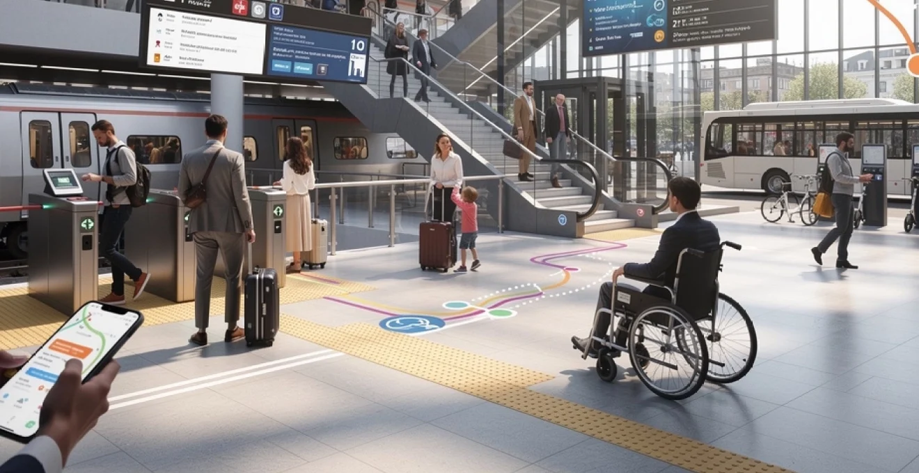
Accessibility features that accelerate transit for reduced mobility passengers
Efficient transport must work for everyone, not just for those who can run up escalators with a suitcase. For passengers with reduced mobility—whether due to disability, age, temporary injury, or travelling with children—small barriers can turn a straightforward connection into a major ordeal. Accessibility features are often framed purely as social or legal obligations, but they also have a clear efficiency dimension. When reduced mobility passengers can navigate interchanges quickly and independently, dwell times decrease, assistance resources are used more effectively, and overall system performance improves.
Designing for accessibility means thinking holistically about the entire journey: from planning and ticket purchase through to boarding, interchanging, and exiting at the destination. Step-free routes, tactile guidance, clear audio and visual information, and reliable assistance services all play a part. In effect, you can think of accessibility features as performance upgrades that benefit every passenger, because features like lifts, level boarding, and intuitive wayfinding also help people with luggage, strollers, or limited time.
Step-free access routes and passenger assist technology at network rail stations
Network Rail has progressively increased the number of step-free stations across Great Britain, supported by programmes such as Access for All. Step-free access typically involves lifts, ramps, or level access bridges that connect platforms to concourses and exits without stairs. However, simply installing lifts is not enough; the routes must be intuitive, well-signed, and maintained in working order. If you have ever arrived at a station to find the lift out of service, you will know how quickly journey plans can unravel without reliable step-free options.
Passenger assist technology further enhances accessibility. Mobile apps and web portals allow passengers to request assistance in advance, specifying their journey, mobility needs, and preferred support. At major stations, staff equipped with handheld devices receive real-time notifications of arriving passengers needing help, enabling smoother transfers and shorter dwell times. Over time, the data generated by these systems helps identify pinch points—stations where extra staff or infrastructure improvements are needed to ensure consistent, efficient support.
Tactile paving standards and audio beacon installation guidelines
For visually impaired passengers, efficient navigation depends on tactile and audio cues embedded in the built environment. Tactile paving—those distinctive raised patterns at platform edges, crossings, and decision points—follows specific standards in the UK and across Europe. Different patterns signal different information: for example, warning of a platform edge or indicating a safe crossing point. When these standards are applied consistently, visually impaired travellers can move more quickly and confidently through stations, reducing the need for one-to-one assistance.
Audio beacons, often triggered via smartphone apps or handheld devices, provide spoken guidance at key locations such as station entrances, ticket machines, and platform access points. Installation guidelines cover not just volume and clarity but also positioning, language options, and trigger ranges to avoid overwhelming people with overlapping messages. When tactile paving and audio beacons are well designed and maintained, they create an accessible navigation “layer” that sits alongside visual signage. This reduces cognitive load for visually impaired passengers and speeds up their movements, contributing to overall network efficiency.
Wheelchair-accessible vehicle scheduling and priority boarding protocols
Wheelchair-accessible vehicles are only truly effective when they are available where and when they are needed. This is why many operators integrate accessibility constraints directly into their scheduling and fleet allocation algorithms. Buses with low floors and deployable ramps, or trains with specific accessible carriages, are assigned to routes and times with higher expected demand from wheelchair users. Real-time updates can inform you if an approaching service has functional accessibility features, allowing better decision-making at the stop or station.
Priority boarding protocols complement vehicle design. Clear markings on platforms, designated waiting areas, and trained staff help ensure that wheelchair users and other reduced mobility passengers can board efficiently without last-minute scrambles. This is not only more dignified; it also reduces dwell times at stops and platforms, which is a significant factor in timetable reliability. When boarding and alighting are smooth, the entire line benefits from fewer knock-on delays.
Automated fare collection systems and barrier-free transit models
Payment friction can be a surprisingly large source of delay and frustration in transport systems. Queues at ticket machines, confusion over fare zones, and inconsistent validation rules all slow down journeys and deter people from using public transport. Automated fare collection (AFC) systems aim to remove as much of this friction as possible by automating ticket purchase, validation, and settlement. Contactless bank cards, mobile wallets, and account-based ticketing platforms are now common across many cities, allowing you to travel without ever handling a paper ticket.
Barrier-free transit models take this a step further by eliminating physical ticket gates in favour of proof-of-payment inspections and back-end validation. In such systems, passengers validate their travel via card taps or QR codes, often on board or at platform level, while roving inspectors perform spot checks. This reduces bottlenecks at station entrances and exits, speeding up passenger flows and reducing the infrastructure required for gate lines. Of course, successful implementation depends on robust enforcement and public trust, but where it works well, it can significantly streamline the journey from one stop to the next.
Modern AFC platforms also support more flexible and equitable fare policies, such as daily and weekly capping, off-peak discounts, and targeted concessions. These features encourage sustainable modal choices by making it cheaper and easier to combine buses, trains, and micromobility in a single day. From an operational standpoint, rich fare data helps authorities understand real travel patterns and design better services. As AFC and barrier-free models continue to evolve, they will play an even greater role in making multimodal transport not only more efficient, but also more accessible and attractive for everyone.