Patagonia stands as one of Earth’s last great wilderness frontiers, stretching across the southern reaches of Chile and Argentina in a magnificent display of untamed landscapes. This vast region encompasses over one million square kilometres of diverse ecosystems, from towering granite spires to ancient glaciers that continue to shape the land. The convergence of the Andes Mountains, Atlantic and Pacific Oceans creates a unique biogeographical zone where temperate rainforests meet windswept steppes, and where some of the world’s most spectacular wildlife thrives in conditions found nowhere else on the planet.
For adventurers and nature enthusiasts, Patagonia offers an unparalleled opportunity to witness geological forces in action, observe endemic species in their pristine habitats, and experience wilderness on a scale that has largely disappeared from other continents. The region’s dramatic weather patterns, influenced by the Southern Ocean’s westerly winds, create an ever-changing canvas of natural phenomena that captivates visitors from around the globe.
Patagonian geological formation and biogeographical zones
The geological foundation of Patagonia tells a story spanning hundreds of millions of years, with dramatic tectonic upheavals and glacial sculpting creating the breathtaking landscapes we see today. Understanding these underlying geological processes provides crucial insight into why Patagonia hosts such remarkable biodiversity and unique ecosystems across its vast expanse.
Andean cordillera tectonic activity and glacial morphology
The Patagonian Andes represent one of the most geologically active regions on Earth, formed by the ongoing subduction of the Nazca and Antarctic plates beneath the South American plate. This tectonic activity continues to push the mountain range skyward, creating the dramatic granite towers and volcanic peaks that define the region’s skyline. The relatively young geological age of these mountains, compared to ranges like the Appalachians or Scottish Highlands, explains their sharp, jagged profiles that haven’t yet been smoothed by millions of years of erosion.
Glacial activity has profoundly shaped Patagonian topography over the past two million years. The Southern Patagonian Ice Field, the world’s third-largest ice mass outside polar regions, continues to carve valleys and sculpt mountain faces through powerful glacial action. These ice rivers, moving at rates of several metres per year, create the distinctive U-shaped valleys, hanging cirques, and terminal moraines that characterise much of the landscape.
The retreat and advance of glaciers throughout various ice ages have left behind a complex network of fjords, lakes, and river systems. Glacial flour, the fine rock particles ground by moving ice, gives many Patagonian lakes their distinctive turquoise colour as these particles remain suspended in the water column, creating stunning visual effects that photographer’s prize.
Valdivian temperate rainforest ecosystem distribution
The Valdivian temperate rainforest represents one of the world’s rarest ecosystem types, found only in small pockets along Patagonia’s western slopes and coastal regions. These ancient forests, dominated by species like the Alerce tree which can live over 3,000 years, create cathedral-like environments with dense canopies that filter sunlight into ethereal beams. The high rainfall levels, often exceeding 3,000 millimetres annually, support an incredible diversity of plant life including numerous endemic species.
These rainforests serve as critical habitat for species such as the endangered Huemul deer, Southern River Otter, and Darwin’s Fox. The understory teems with ferns, mosses, and climbing plants that create complex three-dimensional ecosystems. Many plant species in these forests exhibit unique adaptations to the consistent moisture and filtered light conditions, including unusually large leaf surfaces and specialized root systems for nutrient absorption in waterlogged soils.
Patagonian steppe grassland vegetation patterns
East of the Andes, the landscape transforms dramatically into vast Patagonian steppes, where hardy grasses and shrubs have adapted to semi-arid conditions and persistent westerly winds. These grasslands support massive populations of Guanacos, the region’s largest native herbivore, whose grazing patterns help maintain the ecosystem’s delicate balance. The vegetation here
forms a mosaic of low cushion plants, thorny bushes, and drought-resistant herbs whose root systems stabilise the thin soils. Species such as Stipa grasses and Mulinum spinosum (known locally as neneo) are perfectly adapted to withstand intense solar radiation, poor nutrient availability, and some of the strongest winds recorded at these latitudes. From a distance the steppe may appear monotonous, but close observation reveals subtle zonation driven by soil depth, microtopography, and grazing pressure. Conservationists increasingly monitor these patterns to understand how climate change and overgrazing may shift vegetation belts and, in turn, the distribution of Patagonia’s iconic wildlife.
Southern ocean coastal marine biodiversity hotspots
Where the Patagonian landmass meets the Southern Ocean, powerful currents, nutrient upwelling, and complex coastal geomorphology combine to create exceptional marine biodiversity hotspots. The confluence of the cold Malvinas (Falklands) Current with warmer northern waters fuels massive plankton blooms that support rich food webs from krill to top predators. Along the indented coastline, submerged valleys carved by glaciers now form deep fjords and channels that shelter elephant seals, South American sea lions, and several dolphin species. Offshore, seamounts and submarine canyons act like underwater islands, concentrating fish and squid and drawing in whales during seasonal migrations.
Estuaries and sheltered gulfs, particularly around Peninsula Valdés and the Strait of Magellan, serve as critical breeding grounds for southern right whales and Magellanic penguins. Here, the fine balance between salinity, temperature, and nutrient input creates ideal conditions for raising young. These same areas, however, are among the most vulnerable to human impacts such as ship traffic, fisheries bycatch, and coastal development. When planning a trip that includes marine wildlife watching in Patagonia, choosing operators that follow strict environmental guidelines is one of the most effective ways you can help protect these fragile ecosystems.
Torres del paine national park wilderness navigation
Torres del Paine National Park in Chilean Patagonia has become synonymous with world-class trekking, yet its rugged terrain and volatile weather still demand careful preparation and navigation skills. The park encompasses glaciers, lenga forests, turquoise lakes, and the famous granite towers that give it its name. While waymarked trails like the W Trek and O Circuit are well established, hikers should treat the environment with the same respect they would give to any high-mountain region: conditions can shift from calm sunshine to gale-force winds and sleet within an hour. A solid understanding of route options, elevation profiles, and access logistics will dramatically improve both your safety and your enjoyment.
Base las torres trek route planning and elevation profiles
The classic hike to Base Las Torres is one of the most sought-after day routes in Patagonia, taking most visitors between seven and ten hours round trip. The trail covers roughly 18–22 kilometres (11–14 miles) depending on the starting point, with total elevation gain of about 900 metres (2,950 feet). It begins gently through grassland and low forest near the Ascencio River, then enters a narrow valley where the gradient increases and loose rock becomes more common. The final kilometre ascends a steep moraine, where hikers often gain around 400 metres in less than an hour, before reaching the glacial lagoon and the vertical granite spires of the Torres themselves.
Because of this demanding elevation profile, route planning should account for both fitness level and current trail conditions. Starting early not only avoids afternoon crowds but also gives you the best chance of calmer winds and clearer skies around sunrise. Carrying trekking poles can reduce knee strain on the descent, which many hikers find more taxing than the ascent. If you are new to mountain environments but still want to experience this emblematic trek, you might consider stopping at the Chileno sector or the official viewpoint below the final scramble, which still offers impressive vistas with significantly lower physical stress.
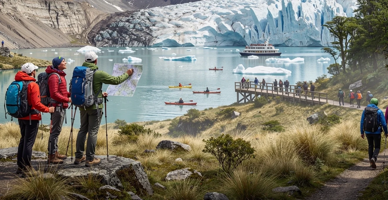
Grey glacier kayaking access points and ice field dynamics
Grey Glacier, flowing from the Southern Patagonian Ice Field into Lago Grey, offers visitors a rare chance to experience glacial environments from water level. Most kayaking excursions depart from the southern shore of the lake near Hotel Lago Grey or from designated beaches accessible by short hikes from the W Trek. Access is typically regulated, and you must join a licensed operator who provides dry suits, safety briefings, and stable double kayaks designed for cold, wind-exposed waters. These trips usually last three to four hours, including time for paddling among floating icebergs that have recently calved from the glacier’s fractured front.
From a geological perspective, Grey Glacier is an active outlet of a larger ice field that still responds sensitively to regional climate shifts. You can often observe distinct crevasse patterns, seracs, and ice caves that reveal how stress and temperature gradients shape the glacier. Kayaking among icebergs, you’ll see layers of compacted snowfall compressed into dense blue ice, a visual reminder that each block represents decades of accumulated winter storms. Guides will typically describe how calving events occur and why wind setup and lake circulation can concentrate brash ice in certain coves. Understanding these dynamics not only enriches the experience but also underscores why strict distance rules are in place to keep kayakers away from the hazardous calving face.
Cuernos del paine granite formation climbing routes
The Cuernos del Paine, instantly recognisable for their dark sedimentary caps resting atop pale granite, are a striking example of intrusive igneous rock punched through older strata. For experienced climbers, these horns offer some of the most compelling big-wall objectives in the Southern Hemisphere, albeit in a remote and serious environment. Routes range from long alpine rock lines on sound granite to mixed climbs that involve ice and snow on the upper sections, with grades that typically require advanced technical ability and solid route-finding skills. Approaches can take several hours across rough moraine and scree, and most ascents demand at least one bivouac on the wall.
Because of the park’s weather reputation—gusts above 80 km/h are not unusual—planning any climbing trip on the Cuernos requires a conservative mindset. Many teams build flexibility into their itineraries, allowing extra days to wait for safe windows. If you are primarily a trekker rather than a climber, you can still appreciate the geological story written in these formations from viewpoints along the W Trek, where interpretive signs explain how magma intruded, cooled, and was later exposed by glacial erosion. In this way, even from the valley floor, you engage with the same geological history that technical climbers experience up close on the walls.
Lago pehoé photography positioning and weather patterns
Lago Pehoé might be one of the most photographed lakes in Patagonia, and for good reason: its milky turquoise waters perfectly mirror the Paine massif when conditions align. To maximise your chances of capturing iconic images, it helps to understand how local weather and light interact with the landscape. Mornings often bring calmer winds and a higher likelihood of reflective surfaces, while afternoons tend to be windier, breaking up the water but sometimes adding dramatic cloud formations over the peaks. Photographers commonly position themselves near the Pehoé camping area or on small peninsulas jutting into the lake, which provide clean sightlines to the Cuernos and central tower group.
Season also plays a significant role in planning your shots in Torres del Paine. During the austral summer (December to February), daylight can extend for up to 17 hours, giving you long golden hours at both ends of the day. In shoulder seasons like October–November and March–April, light tends to be softer, with more frequent storms that can create moody skies and low-lying mist around the mountains. Carrying weather-resistant gear is wise, as squalls can roll in suddenly. Rather than trying to fight changing conditions, many photographers embrace them, using fast-moving clouds and shifting light to convey the park’s dynamic character in a single frame.
Los glaciares national park ice field exploration
Across the border in Argentina, Los Glaciares National Park protects vast swathes of the Southern Patagonian Ice Field and some of the most spectacular mountain scenery on the continent. The park is divided into a southern section centred on the Perito Moreno and Spegazzini glaciers and a northern area around El Chaltén, home to the Fitz Roy and Cerro Torre massifs. Whether you are drawn to accessible boardwalk viewpoints or multi-day alpine climbing objectives, understanding the logistics and environmental dynamics of this protected area will help you make informed decisions about where to focus your time.
Perito moreno glacier calving dynamics and viewing platforms
Perito Moreno Glacier is famous not only for its immense 5-kilometre-wide face but also for its relatively stable mass balance compared to many shrinking glaciers worldwide. Fed by the Southern Patagonian Ice Field, it advances at roughly two metres per day, continually pushing into Lago Argentino. This steady flow results in frequent calving events, where chunks of ice as tall as multi-storey buildings crack off and crash into the water below. The loud cracks and thunderous splashes can often be heard before you see the actual collapse, turning each visit into a suspenseful natural performance.
To observe this process safely, the national park has built an extensive network of steel walkways and viewing platforms on the Península de Magallanes facing the glacier’s northern and southern fronts. These allow you to appreciate different angles and distances while remaining well outside the hazardous calving zone. For a more immersive perspective, boat tours navigate near (but not too near) the ice wall, providing a sense of scale that photographs struggle to convey. If you plan your trip around mid- to late-afternoon, the sun often illuminates the ice from the side, bringing out deep blues and the intricate relief of crevasses and seracs.
Fitz roy massif alpine climbing technical requirements
The Fitz Roy Massif, towering above El Chaltén, has achieved almost mythic status among alpinists for its steep granite faces, complex ridges, and notoriously fickle weather. Technical routes on Fitz Roy and its satellite peaks—such as Poincenot, Guillamet, and Mermoz—typically involve sustained rock climbing at grades of 5.10 and above, combined with sections of mixed or ice climbing near the summits. Climbers must be competent in long multi-pitch systems, glacier travel, crevasse rescue, and rapid retreat techniques, as storms can build quickly and transform benign conditions into whiteout in a matter of hours.
Most expeditions operate on a flexible schedule, basing themselves in El Chaltén and waiting for short, stable weather windows that may last only one or two days. During these windows, climbing teams move fast and light, often simul-climbing easier sections to gain ground before afternoon convection increases wind and cloud cover. For non-climbers, the technical demands of the Fitz Roy peaks might sound extreme, but the same massif offers accessible trails to viewpoints like Laguna Capri and Mirador Fitz Roy. These hikes allow you to appreciate the vertical world of the alpinists from a safe distance while still understanding why this mountain group inspired the logo of the famous Patagonia clothing brand.
Laguna de los tres high-altitude trekking acclimatisation
The trek to Laguna de los Tres, one of Patagonia’s most iconic viewpoints, brings hikers to the base of the Fitz Roy Massif at roughly 1,200 metres above sea level. While this altitude is modest compared to Andean peaks exceeding 6,000 metres, the route’s cumulative elevation gain and steep final ascent make acclimatisation and pacing important considerations. The standard trail from El Chaltén covers about 20–24 kilometres (12–15 miles) round trip, with around 800–900 metres of vertical gain. The last 1.5 kilometres climb a rocky, often wind-exposed slope where progress can slow to a crawl, especially in early season when snow patches linger.
To prepare, many visitors warm up on shorter hikes such as the Laguna Torre or Loma del Pliegue Tumbado trails before tackling Laguna de los Tres. Building a base of several days of moderate effort helps your body adapt to sustained exertion, even if altitude itself is not yet a major factor. Hydration and steady energy intake are also key; think of the trek as a marathon rather than a sprint. If weather deteriorates or fatigue sets in, there are safe turnaround points with rewarding views, including the Laguna Capri area. Recognising when to adjust your plan is part of responsible high-altitude trekking in Patagonia.
Spegazzini glacier boat excursion access routes
The Spegazzini Glacier, another spectacular outlet of the Southern Patagonian Ice Field, is best accessed via boat excursions on the northern arms of Lago Argentino. Departing from Puerto Bandera near El Calafate, vessels navigate through the Upsala Channel (subject to ice conditions) and into the Spegazzini Channel, where steep forested cliffs plunge directly into milky glacial waters. The glacier itself is remarkable for its towering ice front, reaching heights of up to 135 metres, making it one of the tallest in the region. Unlike Perito Moreno, there are no land-based viewpoints close to the terminus, so boat decks become your moving observation platforms.
Operators typically include multiple stops, allowing passengers to disembark at sheltered bays with short viewing trails and interpretive signage. These landings offer a chance to stretch your legs and observe the transition from lenga forest to rocky shoreline and ice-strewn waters. As with any Patagonian boat trip, layering for wind and spray is essential, even on sunny days. If you enjoy photography, consider how you might use the boat’s motion and changing angles to capture different compositions of the ice wall, surrounding peaks, and floating bergs. Planning ahead in this way turns a simple sightseeing excursion into a deeper exploration of glacial landscapes in Los Glaciares National Park.
Peninsula valdés marine wildlife observation protocols
Peninsula Valdés, jutting into the Atlantic on Argentina’s eastern coast, is recognised as a UNESCO World Heritage site for its importance to marine mammals and seabirds. It is one of the best places in the world to see southern right whales calving close to shore, along with orcas, sea lions, elephant seals, and vast colonies of Magellanic penguins. With such concentrations of wildlife, clear observation protocols are vital to minimise disturbance. Local regulations control boat numbers, approach distances, and time spent with any single animal or group, and responsible operators incorporate these guidelines into every excursion briefing.
As a visitor, you play a direct role in maintaining this delicate balance between access and protection. On whale-watching trips, for instance, you may be asked to remain seated on one side of the boat at a time to avoid sudden shifts in weight that could startle the animals. On shore, boardwalks and marked paths keep people away from sensitive breeding areas, particularly during pupping season when adults are easily stressed. It can be tempting to get a little closer for the perfect photo, but even small disturbances—such as raised voices, sudden movements, or approaching too near—can have cumulative impacts over the course of a busy season. By following posted rules and your guides’ advice, you help ensure that future travellers can enjoy the same intimate yet respectful encounters with Patagonia’s marine wildlife.
Tierra del fuego archipelago subantarctic wilderness
South of the mainland, the fragmented islands of the Tierra del Fuego Archipelago form a rugged transition zone between temperate Patagonia and the icy seas of the Antarctic. Shared by Chile and Argentina, this region encompasses snow-capped mountains, peat bogs, and deep channels carved by ancient glaciers. The main Argentine town, Ushuaia, often dubbed “the end of the world,” serves as a gateway for both Antarctic cruises and exploration of Tierra del Fuego National Park. Despite its relative accessibility, the park preserves a sense of subantarctic wilderness: twisted lenga and ñire forests line wind-beaten shores, and trails frequently reveal fox tracks, beaver dams, and the wingbeats of albatross overhead.
For hikers, short but rewarding routes such as the Senda Costera and trails to viewpoints near the Martial Glacier offer glimpses into this unique environment without demanding major expeditions. Kayaking in the Beagle Channel provides a low-lying perspective on rocky islets where cormorants and sea lions haul out, while boat tours visit historic lighthouse sites and remote penguin rookeries. Weather in Tierra del Fuego is notoriously changeable—four seasons in a single day is more the norm than the exception—so layering systems and waterproof outer shells are essential gear. As you move through this landscape, it becomes clear how the combination of latitude, oceanic influence, and Andean geology has created a world that feels simultaneously connected to Patagonia and distinctly its own.
Patagonian weather systems and seasonal wildlife migration patterns
Understanding Patagonian weather systems is crucial for planning any successful trip, whether you are trekking, kayaking, or focusing on wildlife observation. The region sits directly in the path of the Roaring Forties and Furious Fifties, powerful westerly wind bands that circle the Southern Hemisphere. As moist air from the Pacific hits the Andes, it rises, cools, and releases heavy precipitation on the western slopes, creating lush rainforests. By the time this air descends on the eastern side, it has lost much of its moisture, contributing to the arid steppe. This rain-shadow effect, coupled with strong pressure gradients between the polar and subtropical zones, explains why you can experience horizontal rain on one side of the range and clear blue skies on the other.
These atmospheric patterns drive not only local weather but also the timing of wildlife migrations throughout Patagonia. Southern right whales, for example, arrive along the Atlantic coast around June to calve in the comparatively sheltered bays near Peninsula Valdés, staying until November before returning to richer feeding grounds farther south. In Torres del Paine and Los Glaciares, guanaco herds move between winter and summer ranges, tracking snow-free forage and using wind-exposed ridgelines to avoid deep drifts. Birdlife is particularly responsive to seasonal shifts: Andean condors exploit rising thermals on sunny days to soar along cliff faces, while migratory species such as the Austral parakeet and various shorebirds adjust their movements based on food availability and day length.
For travellers, aligning your itinerary with these migration cycles can dramatically shape what you see. If your priority is trekking under long daylight hours, the austral summer from December to February offers the best conditions, albeit with more visitors and stronger afternoon winds. Shoulder seasons—October–November and March–April—often provide a sweet spot of stable weather, fewer crowds, and vivid autumn or spring colours in the forests. Wildlife-focused trips, especially those targeting whales or penguin colonies, tend to cluster between September and early December along the coasts, when breeding activity peaks. By factoring both climate and animal behaviour into your planning, you not only maximise your chances of memorable encounters but also gain a deeper appreciation of how life in Patagonia is finely tuned to one of the most dynamic natural environments on Earth.