Iceland stands as nature’s most spectacular volcanic laboratory, where the Earth’s raw power has sculpted a landscape unlike anywhere else on our planet. This Nordic island nation sits atop one of the world’s most active volcanic regions, where fire meets ice in dramatic fashion to create otherworldly terrains that captivate millions of visitors annually. From the steaming geothermal fields of the Reykjanes Peninsula to the towering calderas of the central highlands, Iceland’s volcanic landscapes offer an unparalleled opportunity to witness geological forces that have been shaping our world for millions of years.
The island’s unique position on the Mid-Atlantic Ridge, combined with the presence of a powerful mantle plume beneath, creates conditions that produce roughly one volcanic eruption every four to five years. These eruptions don’t just threaten – they create. They forge new land, carve spectacular valleys, and generate the geothermal energy that powers modern Icelandic society. Understanding these volcanic processes enhances any visit to Iceland, transforming a simple sightseeing trip into an educational journey through Earth’s most fundamental forces.
Geological formation and volcanic activity patterns across iceland’s landscape
Iceland’s volcanic character stems from its extraordinary geological setting, where two major tectonic plates slowly drift apart whilst a powerful hotspot burns beneath the surface. This combination creates one of Earth’s most volcanically active regions, producing landscapes that range from gentle shield volcanoes to explosive stratovolcanoes and vast lava fields that stretch for dozens of kilometres.
Mid-atlantic ridge dynamics and divergent plate boundary effects
The Mid-Atlantic Ridge represents one of Earth’s most significant geological features, running for over 10,000 kilometres along the Atlantic Ocean floor. In Iceland, this underwater mountain range emerges above sea level, creating a unique opportunity to observe divergent plate boundary processes firsthand. The Eurasian and North American tectonic plates separate at a rate of approximately 2 centimetres per year, a process that might seem imperceptible but produces dramatic results over geological timescales.
This spreading creates a central rift zone that runs roughly northeast to southwest across Iceland, marked by numerous volcanic systems, fissure eruptions, and geothermal areas. The tension created by this pulling apart generates frequent earthquakes and provides pathways for magma to reach the surface. Visitors can observe this process most clearly at Þingvellir National Park, where the rift valley demonstrates the ongoing separation of continents.
Hotspot theory and the iceland plume’s impact on terrain development
Beneath Iceland lies what geologists term a mantle plume – a column of exceptionally hot rock rising from deep within Earth’s mantle. This Iceland plume generates far more volcanic activity than the Mid-Atlantic Ridge alone would produce, explaining why this section of the ridge creates such substantial landmass above sea level. The plume’s influence extends roughly 200 kilometres in diameter, affecting volcanic activity across the entire island.
The hotspot theory explains why Iceland’s volcanic output significantly exceeds that of other ridge segments. Recent studies suggest the plume originates from depths exceeding 2,000 kilometres, bringing primitive mantle material to the surface. This deep source contributes to the chemical diversity observed in Icelandic lavas and helps maintain the high volcanic productivity that has built the island over the past 20 million years.
Quaternary volcanism timeline and holocene eruption cycles
Iceland’s recent geological history reveals distinct patterns of volcanic activity that have accelerated significantly during the Holocene period, particularly over the past 1,000 years. Statistical analysis of eruption records shows that Iceland experiences approximately 20-25 eruptions per century, with notable clustering during certain periods. The medieval period witnessed particularly intense activity, whilst the 17th and 18th centuries saw some of Iceland’s most devastating eruptions.
Modern monitoring reveals that volcanic systems don’t operate independently but show complex interconnections. The 2010 Eyjafjallajökull eruption preceded increased activity at several other volcanic systems, suggesting deep magmatic connections. Current data indicates that periods of enhanced rifting activity, such as the ongoing Reykjanes Peninsula episodes, may continue for decades, providing unprecedented opportunities for volcanic tourism and scientific observation.
Subglacial volcanism and tuya formation processes
One of the most distinctive aspects of Iceland’s volcano landscapes is the way many eruptions take place beneath ice. When magma rises under thick glaciers, it encounters meltwater and ice rather than open air, producing eruption styles quite different from the classic image of a free-standing cone. The pressure of the overlying ice initially suppresses explosive activity, but as meltwater accumulates and pressure drops, violent phreatomagmatic explosions can shatter lava into ash and glassy fragments.
These interactions create flat-topped, steep-sided volcanoes known as tuyas. A typical tuya forms in stages: first, explosive eruptions build a pile of fragmented material beneath the ice; then, as the eruption continues and the volcano nears the ice surface, lava can flow more freely and cap the edifice with a hard basaltic plateau. Once the ice retreats, what remains is a table-mountain profile that seems oddly truncated compared with classic cones.
Iceland hosts numerous textbook examples of these subglacial landforms, especially in regions that were heavily glaciated during the last Ice Age. Mountains such as Herðubreið in the central highlands show this characteristic flat summit and steep flanks, revealing a history of confinement under ice several hundred metres thick. When you see a flat-topped volcano rising from otherwise open lava fields, you are effectively looking at a cross-section of ancient ice thickness and past climate conditions frozen into the rock record.
Modern monitoring of subglacial volcanoes like Katla and Grímsvötn shows that this process is far from over. Eruptions beneath present-day ice caps continue to generate sudden glacial floods (jökulhlaups), reshaping outwash plains and coastal lowlands in a matter of hours. For travellers, these volcano–glacier interactions explain why so many Icelandic valleys end in stark black sandur plains and why bridges and roads along the south coast are built with such robust engineering in mind.
Reykjanes peninsula volcanic systems and geothermal manifestations
The Reykjanes Peninsula is one of the best places to experience active volcanic processes within easy reach of Reykjavík. Here, the Mid-Atlantic Ridge comes ashore and splits into several parallel fissure swarms that run southwest–northeast across a relatively narrow land bridge. Instead of towering central volcanoes, the peninsula is dominated by low shields, crater rows, and young lava fields that record repeated rifting episodes through the Holocene and into the present day.
For visitors, this region offers a compact showcase of Iceland’s volcanic landscapes: fresh lava from recent eruptions, steaming geothermal areas, rugged coastal cliffs, and engineered geothermal power plants all lie within an hour’s drive of the capital. Because the current activity phase on Reykjanes is expected to last for decades, this is likely to remain one of the most dynamic and evolving parts of Iceland’s volcanic terrain.
Fagradalsfjall eruption site analysis and recent volcanic activity
The Fagradalsfjall volcanic system, and its neighbouring fissures at Geldingadalir, Meradalir, Litli-Hrútur and Sundhnúkur, mark the beginning of a new eruptive cycle on the Reykjanes Peninsula. After roughly 800 years of dormancy, magma once again began intruding beneath the peninsula in 2021, culminating in a series of fissure eruptions that have attracted global attention. Rather than explosive ash clouds, these events produced mostly effusive basaltic lava, building shields and lava fields that you can now hike across (where access is permitted).
Geophysical data show that these eruptions are driven by repeated dike intrusions – sheet-like magma bodies that propagate laterally along the plate boundary. Seismic swarms often precede each event, with thousands of small earthquakes marking the path of rising magma. For landscape photographers interested in Iceland volcano images, this area offers a rare chance to document brand-new lava surfaces, flow textures, and degassing cones while still respecting safety closures and gas warnings.
When you walk across the cooled lava fields at Fagradalsfjall, it’s like stepping onto a still-cooling baking tray: the surface may be solid and dark, but just below, temperatures can remain hot for years. The ropey pāhoehoe textures, jagged ʻaʻā blocks, and occasional collapse pits illustrate the internal plumbing of the flows in a way that no textbook can fully convey. Because conditions change quickly, it’s essential to follow updated route information, carry proper footwear, and be prepared for strong winds funnelling through the valleys.
Blue lagoon geothermal field and svartsengi power plant complex
Just west of the main Reykjanes fissure swarms lies the Svartsengi geothermal field, where high-temperature fluids circulate through fractured basalt at depths of 1–2 kilometres. The Svartsengi Power Plant taps this resource to generate both electricity and hot water, demonstrating how Iceland harnesses its volcano landscapes for renewable energy. Superheated steam rises from production wells, spins turbines, and then condenses, with the remaining mineral-rich brine routed into man-made lagoons.
The world-famous Blue Lagoon formed when this silica-rich wastewater began to pond in nearby lava depressions in the late 20th century. Over time, fine suspended silica particles created the lagoon’s characteristic blue-white colour, while dissolved minerals and algae gave it its reputed skin-care properties. Today the Blue Lagoon is carefully managed as both a spa and a visible symbol of Iceland’s geothermal ingenuity, set against pitch-black lava fields and low crater ridges.
From a geological perspective, the Blue Lagoon area offers more than just bathing. Walking paths across the lava reveal thick moss carpets, pressure ridges, and fractures aligned with the peninsula’s rift system. As you move between hot pools and steam vents, it’s worth remembering that all this warmth ultimately traces back to the same mantle plume and rifting processes that build Iceland’s volcanoes. For photographers, contrasting the milky water with dark basalt and rising vapour creates some of the most iconic volcano landscape images in Iceland.
Reykjanes ridge extension and eldvörp lava field characteristics
Offshore, the Reykjanes Ridge continues the Mid-Atlantic Ridge south-westward beneath the Atlantic, but its influence is clearly visible on land in features like the Eldvörp crater row. Eldvörp is a 10-kilometre-long line of spatter cones and small craters formed by a fissure eruption some 800–2,000 years ago. The associated lava field blankets large parts of the peninsula with blocky basalt, providing a striking example of how linear fissure systems can feed extensive flows.
The Eldvörp lava field is relatively young by geological standards, so soil development and vegetation cover remain thin. Walking across it, you encounter fractured crust, hollow lava tubes, and occasional skylights where roofs have collapsed to expose the interior conduits of the ancient flow. These features illustrate how lava can travel kilometres from its source, forming a hidden plumbing network beneath what appears to be solid ground.
Modern geothermal exploration has drilled into the Eldvörp system, confirming that hot fluids still circulate at depth along the same fracture zones that once carried magma. In that sense, the area functions as a living laboratory for how Iceland volcano systems cool and evolve after eruptive phases. If you plan to photograph these landscapes, be prepared for a very rough surface underfoot and pay close attention to marked trails to avoid damaging fragile moss patches that may have taken decades to establish.
Krýsuvík high-temperature geothermal area exploration
The Krýsuvík geothermal area, located in the central Reykjanes Peninsula, showcases some of Iceland’s most accessible high-temperature surface manifestations. Here, acidic steam vents, boiling mud pools, and colourful alteration zones cluster along active faults and fractures. The ground is intensely altered by hot fluids, turning basalt into clays and iron oxides that paint the hillsides in shades of yellow, orange, and red.
At Seltún, wooden boardwalks guide you safely between hissing fumaroles and bubbling pools where temperatures often exceed 100°C just below the surface. The smell of hydrogen sulphide hangs in the air, a constant reminder that volcanic gases are still escaping from magma bodies at depth. It’s easy to imagine this area as a miniature version of the processes operating along the entire Reykjanes rift, concentrated into a few hectares you can explore in under an hour.
Beyond the main geothermal field, the broader Krýsuvík volcanic system includes crater lakes such as Grænavatn and several young lava flows and cones. For those interested in Iceland volcano landscapes, combining a visit here with the nearby coast at Krýsuvíkurberg gives a strong sense of how volcanic and marine processes interact. As always in high-temperature areas, staying on marked paths is essential: the thin crust around mud pots can be like a brittle ice sheet over boiling water, strong until it suddenly is not.
Westman islands volcanic archipelago and surtsey formation
South of Iceland’s main coastline, the Vestmannaeyjar (Westman Islands) archipelago forms a dramatic volcanic outpost in the North Atlantic. These islands are the emergent peaks of a subaerial volcanic system aligned roughly with the Eastern Volcanic Zone on the mainland. Most of the islands are made of young basaltic lava and tephra, shaped by repeated eruptions over the last 10,000 years and heavily sculpted by Atlantic storms.
Heimaey, the largest and only inhabited island, gained global attention during the 1973 Eldfell eruption, when a fissure opened at the edge of town and buried part of the settlement in lava and ash. The emergency response, including continuous seawater spraying to slow the lava, created a rare example of humans successfully altering a lava flow path to save vital infrastructure. Today you can hike Eldfell’s rust-red slopes, gaze over the frozen lava that extended the island’s coastline, and visit museums that document how a modern community coped with a sudden Iceland volcano eruption on its doorstep.
Further offshore lies Surtsey, one of the youngest islands on Earth, which emerged during an undersea eruption between 1963 and 1967. Surtsey’s birth provided scientists with an unprecedented opportunity to study primary ecological succession – how life colonises brand-new volcanic land with no prior soil or vegetation. The island is strictly protected, with access limited to researchers, but aerial photos and interpretive exhibits on Heimaey illustrate how wave erosion, plant colonisation, and bird nesting have reshaped the island in just a few decades.
From a landscape perspective, the Westman Islands demonstrate how quickly volcanic land can appear and how equally quickly the ocean can tear it down again. Sheer sea cliffs, sea stacks, and amphitheatre-like craters make this archipelago a highlight for anyone interested in photographing Iceland volcano coastlines. Boat tours around Heimaey often combine puffin and whale watching with close-up views of lava cliffs, offering a dynamic perspective you cannot obtain from land alone.
Central highland volcanic complexes and caldera systems
Iceland’s central highlands form a vast, sparsely inhabited plateau dominated by volcanic edifices, calderas, and lava deserts. Here, the interaction between rifting, hotspot activity, and repeated glaciations has produced some of the country’s most dramatic yet remote volcano landscapes. Elevations typically exceed 600–800 metres, and the environment is harsh: strong winds, sudden storms, and limited services mean that planning and experience are crucial if you want to explore this interior region safely.
Within this highland expanse, several major volcanic complexes act as keystones in Iceland’s tectonic framework. Stratovolcanoes like Hekla, subglacial calderas such as Katla, large collapse structures like Askja, and extensive fissure swarms associated with Bárðarbunga have all produced eruptions that reshaped the island on regional and even global scales. Understanding their morphology and history adds depth to any journey across Iceland’s interior tracks.
Hekla stratovolcano morphology and historical eruption patterns
Hekla rises from the southern highlands as an elongated ridge rather than a simple conical peak, reflecting its nature as a fissure-fed stratovolcano. Its summit ridge, about 5 kilometres long, is lined with several craters that have evolved through successive eruptions over the last 7,000 years. The flanks are draped in layers of basaltic and andesitic lava interbedded with thick tephra deposits, evidence of both effusive and explosive activity.
Historically, Hekla has erupted more than 20 times since the settlement of Iceland, earning a reputation as one of the country’s most active and unpredictable volcanoes. Intervals between eruptions range from just a few years to more than a century, and medieval Europeans once referred to it as the “Gateway to Hell” due to the scale of its ash clouds. Tephra from Hekla eruptions can be traced across much of Iceland and into Greenland ice cores, providing valuable time markers for both archaeologists and climate scientists.
For modern travellers, Hekla looms above an extensive lava landscape that includes relatively young flows from its 20th-century eruptions. While the volcano itself is closely monitored and climbing routes may be restricted when activity increases, surrounding areas offer numerous vantage points for photographing its snow-streaked ridge and distal lava fields. When you drive across the sandy outwash plains and young flows at its base, you are crossing ground that may have been incandescent just a few human generations ago.
Katla subglacial caldera and mýrdalsjökull ice cap interactions
East of Hekla, the Katla volcanic system hides beneath the Mýrdalsjökull ice cap, forming a 10-kilometre-wide subglacial caldera that is one of Iceland’s most closely watched hazards. Eruptions within this caldera can melt tens of billions of litres of ice in a short time, generating catastrophic jökulhlaups that race down outlet valleys to the south coast. The braided sands of Mýrdalssandur and the wide glacial plains near Vík owe much of their existence to such past flood events.
Katla’s historical eruptions have often been large and explosive, sending ash high into the atmosphere and depositing thick tephra layers over much of southern Iceland. Because much of this activity occurred under ice, direct observation has been limited, but sedimentary records and ice-core data suggest an average of one major eruption every few decades over the last millennium. The volcano’s current “quiet” period, stretching back to 1918, is therefore of great interest to volcanologists.
From a landscape photography perspective, the Katla region offers dramatic contrasts between ice, black sand, and steep green mountains cut by glacial rivers. Guided tours to the Katla ice cave and the surrounding outwash plains give you a safe window into the volcano–glacier system without approaching hazardous zones. When you stand on the bridge across a wide, seemingly dry sandur, it’s worth picturing how that same channel has, at times, carried torrents of muddy, ice-choked water capable of sweeping away roads and bridges within minutes.
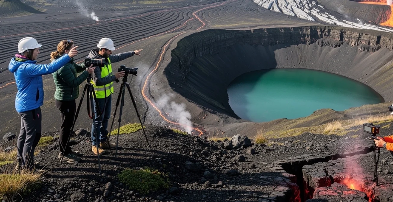
Askja caldera complex and víti crater lake formation
Deep in the northern highlands lies the Askja volcanic complex, a nested caldera system within the Dyngjufjöll mountains. The main caldera, about 50 square kilometres in area, formed through large-scale collapse events associated with major eruptions in the late Pleistocene. Within this depression, subsequent eruptions have built lava shields and smaller craters, most notably during the powerful 1874–1875 explosive event that reshaped the modern landscape.
That 19th-century eruption excavated Víti, a steep-walled maar crater now partially filled by a milky blue-green lake. Víti formed when rising magma encountered groundwater, triggering phreatomagmatic explosions that blasted a 150-metre-wide hole into the older lava. Nearby, the larger lake Öskjuvatn occupies a deeper depression, reaching depths over 200 metres and ranking as one of Iceland’s deepest lakes. Together, these water-filled craters provide a stark contrast of colours against the otherwise barren highland terrain.
Reaching Askja requires traversing long stretches of unpaved highland tracks, often including river crossings and snow patches even in summer. This remoteness is part of its appeal: when you stand on the rim of Víti, with views across dark lava, lingering snowfields, and the calm surface of Öskjuvatn, you gain a strong sense of Iceland’s interior as a true volcanic wilderness. Because conditions can change quickly, especially early or late in the season, checking road status and travelling with experienced drivers or guided tours is highly recommended.
Bárðarbunga-veiðivötn volcanic system and holuhraun lava field
The Bárðarbunga volcanic system, largely concealed beneath the Vatnajökull ice cap, is one of Iceland’s most extensive and powerful. It consists of a central, ice-covered caldera about 10 kilometres across, feeding a fissure swarm that stretches more than 100 kilometres to the southwest (Veiðivötn) and northeast. Throughout the Holocene, this system has produced some of the largest known basaltic fissure eruptions on Earth, rivalled only by events like Laki in the late 18th century.
In 2014–2015, a dike propagated from Bárðarbunga’s caldera to the Holuhraun plain north of Vatnajökull, where it erupted for several months. The resulting lava field, covering roughly 85 square kilometres, is Iceland’s largest since the Laki eruption and provides an excellent example of a modern flood basalt event. Satellite data and gas measurements during this period revealed sulphur dioxide emissions on par with major industrial regions, temporarily affecting air quality across parts of Iceland and even mainland Europe.
Today, the Holuhraun lava field offers a stark, blocky expanse of fresh basalt that has barely begun to weather. Access is strictly controlled and subject to change, but aerial tours and distant viewpoints within the highlands allow you to appreciate its sheer scale. Thinking of the eruption as a slowly poured river of rock can help visualise what happened here: over several months, molten basalt flowed steadily from a line of vents, thickening and spreading until it solidified into the undulating surface you see now. For anyone interested in photographing wide Iceland volcano panoramas, this region exemplifies the overwhelming scale of highland eruptions.
Northern iceland rift zone and lake mývatn volcanic region
North Iceland hosts another segment of the active rift zone, where plate divergence and hotspot influence combine to produce a concentrated cluster of volcanic and geothermal features around Lake Mývatn. Unlike the stark highlands, this area includes fertile lowlands and a relatively mild microclimate, creating an unusual juxtaposition of rich birdlife and fresh lava fields. The result is one of Iceland’s most varied volcano landscapes in a compact region.
Here you can explore everything from active geothermal fields and young crater rows to pseudocraters formed by explosive steam blasts beneath lava. The diversity of landforms within short driving distances makes the Mývatn area ideal for travellers who want to understand different eruption styles without long highland crossings. It is also one of the best locations for capturing Iceland volcano photos that combine volcanic geology with lakes, vegetation, and seasonal light.
Krafla volcanic system and leirhnjúkur lava fields
The Krafla volcanic system lies just north of Lake Mývatn and consists of a central caldera about 10 kilometres wide, surrounded by fissure swarms that extend tens of kilometres along the rift. Between 1975 and 1984, a period known as the Krafla Fires saw repeated dike intrusions and eruptions that dramatically altered the local landscape. Ground deformation of up to several metres was recorded as magma moved in and out of shallow reservoirs, offering a rare, well-monitored example of rift-zone volcanism in action.
Leirhnjúkur, on the caldera’s western edge, is the best place to see the surface result of these events. Here, still-warm lava fields with cracked crusts, steam vents, and sulphur deposits give the impression that the eruption ended only yesterday. Dark ʻaʻā flows overrun older moss-covered surfaces, providing a clear visual timeline of eruptive phases. Walking the marked paths, you pass steaming fissures and vents where residual heat and gas continue to escape decades after the last lava reached the surface.
Just east of Leirhnjúkur lies the small maar crater Viti (not to be confused with Askja’s Víti), filled with a cold, turquoise lake that contrasts sharply with the surrounding dark scoria. This crater formed in a violent explosion in 1724 during a phreatomagmatic event at the start of the so-called Mývatn Fires. Standing on its rim, you can look out over the broader Krafla caldera and appreciate how caldera collapse, fissure eruptions, and hydrothermal activity together shape the northern rift zone.
Pseudocrater formation at skútustaðagígar and explosive volcanism
On the southern shore of Lake Mývatn, the Skútustaðagígar pseudocraters present a very different type of volcanic landform. Unlike true craters that sit directly above vents, pseudocraters form when hot lava flows over wet ground, marshes, or shallow lakes. Steam generated beneath the advancing lava builds pressure until it erupts explosively through the overlying basalt, fragmenting it and creating crater-like mounds without any direct magma conduit below.
The resulting structures often resemble classic small cones, complete with circular rims and central depressions, but their internal stratigraphy reveals a mix of fragmented country rock and lava clasts. At Skútustaðagígar, several dozen of these features dot the lakeshore, some partly eroded or flooded, demonstrating different stages of their evolution. Boardwalks and trails allow you to walk along their rims and interiors, with interpretive signs explaining how they differ from true volcanic vents.
From a visitor’s perspective, pseudocraters are an excellent reminder that not all explosive volcanism involves direct contact with the atmosphere. Here, the key interaction is between lava and external water, a process that also plays a role in creating some subglacial landforms elsewhere in Iceland. When you photograph these mounds against the backdrop of Mývatn and distant mountains, you are capturing one of the most accessible examples of lava–water interaction in the country.
Námaskard geothermal area and fumarolic activity patterns
East of Lake Mývatn, the Námaskarð (also called Hverir) geothermal area showcases intense fumarolic and mud pot activity along a low pass beneath the Námafjall ridge. Here, acidic steam rich in sulphur and other volatiles issues from fractures in the altered ground, while boiling mud pools slowly churn and bubble. The surrounding soil is bleached and stained by mineral deposition, turning the landscape into a palette of whites, yellows, reds, and browns.
The pattern and intensity of fumaroles at Námaskarð reflect both the permeability of the fractured basalt and the depth and temperature of circulating hydrothermal fluids. Over time, vents can migrate, intensify, or shut down as mineral precipitation seals some pathways and opens others. This dynamic behaviour means the exact configuration of steaming ground is never quite the same from year to year, though the general distribution along faults remains consistent.
For travellers, Námaskarð offers one of the most photogenic geothermal scenes in Iceland, especially on cool days when steam plumes condense dramatically against the sky. However, the same processes that create this spectacle also pose hazards: the crust around mud pots can be as thin as an eggshell, with scalding mud or water just centimetres below. Staying on marked paths is not just a formality here; it’s the difference between safe observation and serious injury.
Practical volcano tourism planning and safety protocols for landscape photography
Exploring Iceland’s volcano landscapes is incredibly rewarding, but it also demands thoughtful planning and a clear understanding of the environment’s risks. Eruptions, gas emissions, glacial floods, sudden weather shifts, and unstable ground can all turn a casual outing into a dangerous situation if you are unprepared. The goal is to experience these active landscapes safely, capturing memorable images and insights without putting yourself or others at risk.
Before heading into any active volcanic or highland area, it’s wise to ask yourself a few key questions: Do you understand the current activity level of nearby volcanoes? Are road and weather conditions suitable for your vehicle and experience? Do you have a realistic sense of your own hiking and navigation abilities? Taking the time to answer these honestly will help you match your itinerary to conditions on the ground rather than to an idealised wish list.
- Check official updates daily, especially from the Icelandic Meteorological Office (
vedur.is) and the Icelandic Road and Coastal Administration (road.is), for eruption alerts, gas warnings, and road closures. - Use
Safetravel.isto register your travel plans in remote areas and review current safety advisories related to Iceland volcano regions. - Carry appropriate gear: layered clothing, waterproof outerwear, sturdy hiking boots, navigation tools, and, in winter or shoulder seasons, traction aids for ice and snow.
When photographing volcanic landscapes, additional precautions come into play. Fresh lava fields can conceal thin crusts over hot cavities, and gas pockets may accumulate in depressions, especially on calm days. Keeping a safe distance from steaming vents, fissures, and canyon edges is crucial, even if it means forgoing a dramatic close-up shot. A telephoto lens can often capture the same detail from a far safer vantage point, turning restraint into part of your creative toolkit.
Weather is another major factor for anyone planning Iceland volcano photography. Strong winds can make it difficult to stand steadily near ridgelines or cliffs, while rapid temperature drops can create icy surfaces on previously dry trails. In winter, limited daylight means you should plan your movements around sunrise and sunset, prioritising locations you can reach and leave in full light. Always carry more warm layers and food than you think you’ll need; if conditions deteriorate, being able to wait safely for a few hours can make a critical difference.
Finally, responsible behaviour helps preserve these fragile landscapes for future visitors and for ongoing scientific research. Staying on marked paths protects delicate mosses and geothermal crusts that may take decades to recover from a single footprint. Respecting closures around active eruption sites and glacial rivers reduces pressure on search and rescue teams, who already face challenging conditions when responding to genuine emergencies. By approaching Iceland’s volcano landscapes with a mix of curiosity, preparation, and respect, you can enjoy some of the most spectacular terrain on Earth while helping to keep it – and yourself – safe.