Navigating public transportation in an unfamiliar city can transform from a daunting challenge into one of the most rewarding aspects of travel. Public buses, in particular, offer an authentic window into local life while providing cost-effective, environmentally conscious transit across urban landscapes. Unlike the sterile experience of taxi rides or the isolation of rental cars, buses immerse you in the rhythm of daily commutes, neighborhood characters, and cultural nuances that guidebooks rarely capture. Mastering bus systems abroad requires more than simply hopping aboard—it demands strategic preparation, technological savvy, and cultural awareness. With approximately 60% of European city dwellers relying primarily on public transport for daily movement, understanding these systems positions you alongside locals rather than as a bewildered tourist. The difference between confidently navigating bus networks and wandering lost at interchange stations often comes down to preparation and knowledge of the right tools and protocols.
Pre-journey route planning using digital transit mapping tools
Before setting foot in a new destination, thorough route planning distinguishes confident travelers from those perpetually consulting maps at bus stops. Digital mapping technology has revolutionized transit navigation, transforming what once required physical map literacy and local knowledge into smartphone-guided precision. The contemporary traveler benefits from sophisticated applications that integrate real-time data, multiple transportation modes, and user-generated updates into seamless journey planning.
Leveraging google maps transit layer for Real-Time scheduling
Google Maps has evolved beyond simple driving directions to become an indispensable transit companion across major metropolitan areas worldwide. The transit layer functionality displays bus routes, stop locations, departure times, and even vehicle capacity estimates during peak periods. When you input your destination, the application calculates multiple route options, comparing journey duration, number of transfers, and walking distances between stops. Real-time updates alert you to service disruptions, delays, or route changes—information that proves invaluable when navigating unfamiliar systems. The offline map download feature allows you to access saved areas without data connectivity, though real-time information requires an internet connection. Studies show that travelers using real-time transit apps reduce average journey times by 15-20% compared to those relying solely on printed schedules.
Moovit and citymapper applications for Multi-Modal journey planning
Specialist transit applications often outperform general mapping tools in specific urban environments. Citymapper excels in major cities where it operates, providing granular detail about which carriage to board for optimal exit positioning, live crowding information, and even calorie estimates for walking portions. The application integrates buses, metros, trams, ferries, and bike-sharing schemes into unified journey suggestions. Moovit functions across more than 3,400 cities globally, making it particularly valuable for travelers visiting multiple destinations. Its crowd-sourced data model incorporates user reports about service irregularities, creating a dynamic information network. Both applications support step-by-step navigation with alerts as you approach your destination stop—particularly helpful when unfamiliar street names make visual identification challenging.
Downloading offline transit maps via maps.me before arrival
Internet connectivity proves unreliable in numerous travel scenarios—underground stations, remote neighborhoods, or when roaming charges make data usage prohibitively expensive. Maps.me addresses this limitation through comprehensive offline mapping that includes public transport information. Before departure, download destination city maps over WiFi, ensuring access regardless of connectivity. The application displays bus routes, stop locations, and basic scheduling information without requiring data. While lacking real-time updates, this offline capability provides essential navigation when other tools fail. Experienced travelers maintain multiple mapping applications, recognizing that different tools excel in different circumstances and redundancy prevents navigation failures.
Understanding zonal fare structures in european metropolitan networks
European cities frequently employ zonal pricing models that initially confuse visitors accustomed to flat-rate systems. Transport networks divide service areas into concentric zones radiating from city centers, with fares calculated based on zones traversed. London’s system, for instance, spans nine zones, with central Zone 1 encompassing major tourist attractions. A journey from Zone 1 to Zone 3 costs significantly less than one extending to Zone 6. Understanding which zones your accommodation and planned destinations occupy allows accurate budget planning and appropriate ticket purchasing. Paris operates similarly with five concentric zones, though visitors rarely venture beyond Zone 3
for sightseeing. When using buses in zonal systems, always verify whether your ticket or pass covers all the zones you will cross on a given day. Buying the correct pass upfront not only reduces costs but also eliminates the stress of on-board inspections or surprise fines, which are common in cities like Berlin, Vienna, and Madrid when passengers stray beyond their valid zones.
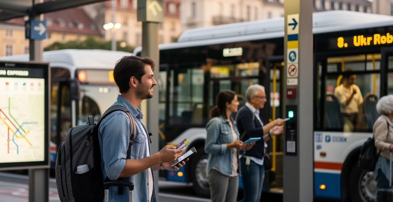
Contactless payment systems and fare collection methods across major cities
Once you understand the route network and fare zones, the next critical step is mastering how to pay for public buses efficiently. Fare collection systems have evolved rapidly, with contactless smartcards, bank card payments, and mobile ticketing now standard across many major cities. Learning how these systems operate before you arrive means you can board confidently, avoid delays at ticket machines, and minimize the chances of accidental fare evasion. From London’s Oyster card to Paris’ Navigo and app-based passes in North America, each city offers slightly different but increasingly user-friendly options.
Transport for london oyster card versus contactless bank card tap systems
London is often cited as a benchmark for modern bus fare collection, and understanding its model helps you interpret similar systems elsewhere. The Oyster card is a reloadable smartcard used across the Transport for London (TfL) network, including buses, the Underground, trams, and certain rail services. You tap in when boarding a bus and the fare is automatically deducted, with daily and weekly caps ensuring you never pay more than a set maximum. For many visitors, however, using a contactless bank card or mobile wallet (Apple Pay, Google Pay) is even more convenient, as it operates on the same fare caps without requiring a physical transit card purchase.
The key rule in London—and in other cities adopting similar systems—is consistency: always use the same card or device for all your taps so the system can calculate caps correctly. If you tap in with your physical bank card in the morning and your phone in the afternoon, they will be treated as two separate accounts, potentially costing you more. On buses, you only tap in (no tap out), which simplifies the process, but on rail services you must tap both in and out to avoid being charged the maximum fare. Think of the system as a digital toll gate: the entry and exit points define your journey and cost, so accurate tapping is essential.
Navigo pass integration in paris RATP network
Paris’ RATP network—covering buses, the Metro, RER trains, and trams—relies heavily on the Navigo system for regular users and longer-stay visitors. The Navigo pass is typically loaded with weekly or monthly travel products that grant unlimited rides within selected zones, most commonly zones 1–2 or 1–5 for tourists. Once loaded, you simply validate the pass at the gate or validator and then board buses without additional transactions. This integration across modes makes it particularly attractive if you plan to use both buses and the Metro extensively during your stay.
In practice, using Navigo on buses is straightforward: you approach the validator near the driver, hold the card flat against the reader, and wait for the audible beep or green light. What many visitors overlook is that Paris has been gradually rolling out contactless, ticketless options via smartphones, especially on Android devices with NFC. However, these solutions can have regional or device restrictions, so checking eligibility before departure is wise. As with London, ensure the zones on your Navigo cover any trips to airports or outer suburbs—understanding zone boundaries in advance helps you avoid last-minute purchases at higher single-ride prices.
Mobile ticketing applications: token transit and regional provider apps
Beyond Europe’s large smartcard ecosystems, many cities worldwide are adopting mobile ticketing platforms like Token Transit, Justride, or proprietary regional apps. These applications allow you to purchase, store, and validate bus tickets directly on your smartphone, often supporting single rides, day passes, and longer-term products. After payment, tickets appear as digital passes with QR codes, animated elements, or color-changing screens to prevent screenshots and fraud. For travelers who prefer not to carry multiple cards or cash in a new destination, mobile tickets offer a streamlined, contactless solution.
Using these apps effectively requires a small amount of preparation. You typically need to create an account, link a payment method, and sometimes download specific city or agency “modules” within the app. On boarding, you either scan a QR code on the bus validator or show the animated ticket to the driver, depending on the system. Have you ever fumbled at the entrance, trying to find the right ticket screen while a queue forms behind you? Activating your ticket just before arrival at the stop, and keeping the brightness high and phone ready, helps you board smoothly and avoids awkward delays.
Paper ticket validation machines and time-stamping protocols
Despite the rise of digital payments, paper tickets remain common, especially in mid-size European cities and rural networks. These tickets often operate on a time-based validation model: you buy a ticket at a kiosk or machine, then insert or scan it in a validator on board or at the station to “start” its validity. From that moment, you might have 60–120 minutes of unlimited transfers within certain zones. Failing to validate is treated the same as not having a ticket at all, even if you purchased one, and fines can be substantial.
Validation machines typically punch a timestamp and sometimes a route code into the ticket. In Italy, for example, small yellow or orange machines on buses stamp the date and time; in Germany and Austria, blue validators perform a similar role. Think of this as clocking in at work—the ticket is only active once it has a recorded start time. When boarding, always look for a validator near the doors and listen for the mechanical punch or beep. If you are unsure whether to validate again when transferring, ask a local or driver; double-validating can waste value, while failing to validate can lead to fines during random inspections.
Decoding route numbers, terminus indicators, and service frequency patterns
Once your payment method is sorted, the next challenge is understanding what all those numbers, letters, and destination names actually mean on bus stops and vehicle displays. Bus systems may appear chaotic at first glance, but they generally follow consistent logic. Route numbers, terminus indicators, and frequency patterns are like the grammar of a new language: once you grasp the rules, you can quickly interpret unfamiliar lines. Learning to decode this “grammar” helps you avoid boarding the wrong direction or waiting unnecessarily when faster options exist.
Route numbers usually indicate the general corridor or service type, while the terminus name shows the ultimate end of the line in that direction. For example, a bus labeled 24 – Central Station will be heading toward the central transportation hub, whereas the same line might display 24 – Riverside Park in the opposite direction. In some cities, letters differentiate variants of the same route, such as 24A taking a small detour through a residential area. When you are unsure, compare the displayed terminus with printed or digital stop lists; if your stop appears between your current location and that terminus, you are on the correct bus.
Service frequency patterns are equally important when planning sightseeing days or evening outings. Timetables may list headways (for example, “every 7–10 minutes”) during peak periods and specific departure times in off-peak hours. As a general rule, city-center routes run more frequently than peripheral services, and weekend or late-night schedules are thinner. Treat high-frequency routes like metro lines where you can “turn up and go,” but approach low-frequency routes with the precision of catching a long-distance train—missing a bus that comes once an hour can seriously disrupt your day. Digital transit apps can display live countdowns, but it is still wise to note the last departure back toward your accommodation, especially on Sundays and holidays.
Vehicle identification and platform navigation at multi-bay interchanges
Major bus interchanges and central stations can feel like small airports, with multiple bays, overlapping routes, and constant arrivals and departures. In such environments, knowing how to identify the correct vehicle quickly is essential. Clear LED destination displays, alphanumeric codes, and logical bay numbering systems are designed to guide you, but they can still be overwhelming when you first arrive. Approaching these hubs with a systematic strategy—much like reading a departure board at a rail station—will help you move confidently, even during busy commuter peaks.
LED destination displays and alphanumeric route coding systems
Modern buses typically use bright LED destination displays on the front, side, and sometimes rear of the vehicle. These show the route number or code and the terminus or main destination, occasionally scrolling through intermediate points of interest. Alphanumeric coding systems, combining letters and numbers such as X10, M3, or N25, usually signal specific service characteristics: X for express, M for metro-style frequent routes, N for night services. Learning this shorthand is like decoding airport flight numbers—once you know that N means night bus, you instantly recognize after-hours options.
When standing on a crowded platform, resist the urge to board the first bus that looks approximately right. Instead, confirm three details: the route number, the destination displayed, and any additional service notes (such as “short working” or “limited stop”). Some systems display “via” information—e.g., 15 – Harbor via Old Town—which tells you whether the bus passes through neighborhoods you want to visit. If the LED display cycles through multiple screens, watch a full loop before boarding, or quickly ask the driver, “Does this go to [your stop]?” in the local language or with the name written on your phone.
Understanding bay numbering at central coach stations
Multi-bay interchanges usually employ logical bay numbering systems, but layouts differ widely between countries. Some follow a simple numerical sequence around an island platform (Bays 1–10 in a clockwise direction), while others assign specific carriers or route groups to designated areas. Station signage often includes both a static map and dynamic electronic boards pointing you to the correct bay. Treat these boards as you would an airport departures screen: find your route number, check the scheduled time and destination, then note the bay assignment.
At bus terminals serving both local and regional services, it is common for longer-distance coaches to depart from outer bays, with city buses closer to station buildings or metro connections. Arriving early—10–15 minutes before departure—gives you time to locate the bay calmly and adjust if there is a last-minute gate change. Have you ever watched a bus pull away from the adjacent bay just as you realized it was yours? Keeping an eye on both the physical signage at the bay and the central display boards helps you spot such changes. When in doubt, showing your ticket or destination to station staff or nearby passengers remains one of the fastest ways to verify you are waiting in the right place.
Distinguishing express services from local stopping patterns
Not all buses that share a corridor stop at the same intermediate stops, and confusing an express with a local service can leave you racing past your intended destination. Express services typically make fewer stops and are labeled with distinctive codes or color schemes, such as EX1, X7, or a different background color on route maps. Local buses, by contrast, stop at most or all designated stops along the line. Understanding this difference is particularly important when traveling to airports, outer suburbs, or intercity transfer points where multiple services operate along a shared roadway.
Timetables and stop signage generally indicate whether a bus is “limited stop,” “rapid,” or “express.” Think of express buses as the equivalent of an intercity train that only stops at major stations, while local buses resemble commuter trains making all local stops. When planning your journey, decide whether speed or stop proximity matters more for that particular trip. If you are carrying heavy luggage or traveling in extreme weather, a local service that drops you closer to your accommodation may be preferable to a faster express that requires a longer walk. Digital mapping tools can highlight these trade-offs, but it is still prudent to confirm on the ground by checking the stop list displayed at shelters or on the vehicle itself.
Passenger etiquette protocols and cultural transit norms by region
Using public buses is not only about logistics; it is also about integrating smoothly into local transit culture. Passenger etiquette varies by country and even by city, and observing these unwritten rules can significantly enhance your travel experience. While basic courtesy—such as offering seats to those in need and queuing without pushing—is universal, the finer details change with regional norms. Paying attention to how locals behave on buses is one of the fastest ways to acclimate and avoid standing out as an inconsiderate visitor.
In Northern and Central Europe, for example, silence and personal space are highly valued. Conversations are kept low, phone calls are brief, and listening to music without headphones is considered rude. Queues at bus stops are orderly, and passengers typically wait for others to disembark fully before boarding. In Southern Europe and parts of Latin America, by contrast, buses can be more social environments, with lively conversations, occasional street performers, and more flexible boarding lines. Neither approach is “better”; they simply reflect cultural preferences. By matching your behavior to the local pattern, you show respect and reduce friction.
Seat etiquette also follows clear patterns. Priority seats near the front are reserved for elderly passengers, people with disabilities, pregnant individuals, and those with small children. Even if signs are not obvious, yielding your seat in these situations is an almost universal expectation. In some Asian cities, seats may be color-coded or accompanied by pictograms indicating who they are intended for. Additionally, eating and drinking rules differ: in cities like Singapore or Tokyo, consuming food on public transport can incur fines, while in others a coffee cup is unremarkable. When in doubt, look around—if no one else is eating, it is safer to wait until you disembark.
Personal security practices form another layer of etiquette. Keeping backpacks off your back and holding them in front of you in crowded buses both protects against pickpockets and creates more space for others. Standing clear of doors when the bus stops allows smoother flows of passengers on and off, a small gesture that locals appreciate. You might notice unspoken conventions around phone volume, bag placement, and even where to stand relative to older passengers. By consciously observing and mirroring these habits, you quickly move from feeling like an outsider to blending into the everyday rhythm of the route.
Safety protocols for solo travellers on night bus services and off-peak routes
Night buses and off-peak services offer valuable flexibility, especially in cities where rail lines close early or taxis are expensive. However, traveling alone at night requires a slightly different mindset from daytime journeys. With fewer passengers, reduced staff presence, and limited alternative options if something goes wrong, it is sensible to adopt a more proactive safety strategy. This does not mean avoiding night buses altogether—in many cities they are well-used and secure—but rather approaching them with awareness and planning.
Start by planning your route in detail before you set out. Check last bus times in both directions, identify key transfer points, and save your accommodation address and nearest stops offline in your transit app. Consider sharing your live location with a trusted friend or family member via your smartphone, especially if you anticipate a long journey or multiple transfers. Boarding earlier in the route, where there are more people, can feel safer than catching a nearly empty bus at an isolated stop. Have you ever realized too late that your stop is in a poorly lit industrial area? Reviewing street imagery in mapping tools beforehand can help you choose safer disembarkation points, even if it means a slightly longer walk.
On board, many solo travelers prefer to sit closer to the driver or in well-lit sections of the bus where other passengers are present. Keeping headphones volume low or using only one earbud allows you to stay alert to announcements and your surroundings. Guard your belongings by keeping your bag on your lap or between your feet with a strap looped around your leg or arm; this simple habit deters opportunistic theft. Avoid displaying high-value items such as large cameras, thick wallets, or multiple phones, particularly in cities known for pickpocketing on public transport.
If at any point you feel uncomfortable—whether due to another passenger’s behavior, an unexpected route diversion, or a sudden loss of familiar landmarks—trust your instincts. You can move to a different seat, change buses at a busier stop, or, if necessary, get off in a well-lit public area such as a main square or near a 24-hour business. Many cities now equip buses with on-board CCTV and emergency intercoms near doors, allowing you to alert the driver discreetly. Treat these tools like a safety net: you may never need them, but knowing they exist and where they are located provides reassurance.
Finally, have a backup plan in case your bus is canceled, full, or significantly delayed. This might include having a local taxi app installed, enough credit on your phone for calls, or a small emergency fund for an unplanned ride-share. Think of it as carrying a spare tire—you hope your journey runs smoothly, but you are prepared if it does not. By combining thoughtful route planning, situational awareness, and a few practical safeguards, you can confidently use night buses and off-peak services to expand your exploration of a new destination, rather than feeling constrained by the clock.