Namibia’s desert landscapes represent one of Earth’s most extraordinary geological achievements, where ancient processes have sculpted a terrain unlike anywhere else on the planet. The country’s position along Africa’s southwestern coast has created a convergence of geological forces that have shaped hyperarid environments spanning millions of years. From the towering sand dunes of the Namib Desert to the mineral-rich pavements of the Kalahari, these landscapes tell a story of planetary evolution that continues to captivate scientists and travellers alike.
What makes Namibian deserts truly exceptional is their remarkable diversity within extreme aridity. The interaction between ancient continental processes, oceanic currents, and climatic systems has produced ecosystems where life thrives against seemingly impossible odds. This unique combination of geological antiquity and biological innovation creates landscapes that challenge our understanding of how desert environments function and evolve over geological timescales.
Geological formation processes behind namibia’s ancient desert terrains
The foundation of Namibia’s unique desert character lies in geological processes that began over 180 million years ago. Understanding these deep-time mechanisms reveals why Namibian landscapes possess such distinctive characteristics compared to other global desert systems. The interplay between continental drift, crustal stability, and erosional patterns has created the perfect geological canvas for today’s extraordinary desert formations.
Gondwana supercontinent breakup and namibian desert genesis
The breakup of the Gondwana supercontinent fundamentally shaped Namibia’s geological destiny, creating the structural foundation for its modern desert systems. As South America separated from Africa approximately 130 million years ago, the process generated massive geological stresses that influenced regional topography and drainage patterns. This continental rifting created the initial conditions for the Namib Desert’s formation by establishing the coastal orientation that would later interact with oceanic currents.
The rifting process also influenced the distribution of basement rocks and sedimentary sequences across the region. Tectonic uplift associated with continental separation created elevated margins along what would become Namibia’s coast, establishing the topographical framework that continues to influence modern wind patterns and precipitation distribution. These ancient geological events set the stage for the hyperarid conditions that characterise contemporary Namibian deserts.
Kalahari craton stability and Million-Year erosional patterns
The remarkable stability of the Kalahari Craton, one of Earth’s most ancient geological formations, has profoundly influenced Namibian desert development over hundreds of millions of years. This cratonic stability has prevented major tectonic disruptions, allowing erosional processes to operate consistently across vast timescales. The result is a landscape where weathering patterns have created distinctive desert pavements and exposed ancient rock formations that are rarely visible elsewhere on Earth.
Erosional processes operating on this stable foundation have produced the characteristic flat-topped mountains and extensive gravel plains that define much of Namibia’s desert topography. The slow, steady removal of surface materials over millions of years has exposed Precambrian rocks that provide insights into Earth’s early geological history. These erosional patterns continue to shape contemporary landscape evolution, creating the distinctive geomorphological features that make Namibian deserts so visually striking.
Atlantic ocean formation impact on namib desert aridity
The formation of the South Atlantic Ocean created the oceanic conditions that transformed Namibia’s climate from potentially humid to hyperarid. As the ocean basin widened and deepened, it established the circulation patterns that would bring cold water northward along Africa’s western coast. This oceanic configuration became crucial for developing the extreme aridity that characterises the Namib Desert today.
The positioning of Namibia relative to the newly formed Atlantic also influenced atmospheric circulation patterns that contribute to desert formation. Subsidence zones created by the interaction between continental and oceanic air masses established the high-pressure systems that prevent moisture-bearing clouds from reaching the interior. This atmospheric configuration, combined with oceanic influences, created one of Earth’s most stable hyperarid environments.
Precambrian basement rock exposure in desert pavements
Namibian deserts showcase some of the world’s most extensive exposures of Prec
cambrian basement rocks within its desert pavements, gravel plains, and inselbergs. These ancient crystalline rocks, often more than 2.5 billion years old, are revealed where younger sediments have been stripped away by relentless wind and sporadic water erosion. Walking across these surfaces, you are literally treading on some of the oldest exposed crust on the planet, a key reason why Namibia’s desert landscapes feel so geologically “ancient”.
These desert pavements—mosaics of tightly packed stones polished by sandblasting—are not just visually striking. They also play a functional role in the Namibian desert environment by protecting fine sediments below from further erosion and helping to stabilise the surface. For geologists and travellers alike, these pavements offer an open-air archive of Earth history, where rock textures, mineral veins, and weathering rinds reveal stories of deep time that few other desert environments preserve so clearly.
Namib desert’s extraordinary dune systems and sand sea formations
If the bedrock tells the long story of Namibia’s deserts, the dune systems are the dynamic, ever-changing chapter being written in real time. The Namib Sand Sea, a UNESCO World Heritage Site, stretches for hundreds of kilometres and includes some of the tallest and most visually dramatic dunes on Earth. What makes this sand sea unique is not just its size, but the complex interaction between wind regimes, coastal influences, and sediment supply that shapes each dune into a distinct geomorphological form.
Unlike many deserts where dunes form simple, uniform patterns, the Namib presents an intricate mosaic of star dunes, linear dunes, barchans, and climbing dunes that evolve under multi-directional wind fields. For visitors, this means that every valley and ridge reveals a different sculptural form, from knife-edge crests to broad, rolling shoulders of sand. For scientists, these dune systems are a natural laboratory for understanding how wind, gravity, and time produce the architecture of a true sand sea.
Sossusvlei’s star dune morphology and wind pattern dynamics
Sossusvlei, one of Namibia’s most iconic destinations, is renowned for its towering star dunes—immense pyramids of sand with radiating arms. These dunes form where winds blow from several dominant directions over long periods, causing sand to pile upward rather than migrate steadily across the landscape. The result is a cluster of almost stationary giants, some over 300 metres high, that maintain their overall shape even as individual sand grains are constantly on the move.
By climbing a Sossusvlei dune at sunrise, you can observe how subtle wind shifts have carved sharp ridges on one face while rounding others into sweeping curves. The wind pattern dynamics here are so pronounced that researchers use the Namib as a reference model to interpret ancient dune deposits on Earth and even dune fields on Mars. For photographers and travellers seeking the most unique desert landscapes in the world, Sossusvlei’s star dunes offer both a visual spectacle and a living demonstration of atmospheric physics at work.
Sandwich harbour’s coastal-desert interface mechanics
Further north, Sandwich Harbour presents one of Namibia’s most dramatic juxtapositions: towering dunes that plunge directly into the Atlantic Ocean. Here, the mechanics of the coastal-desert interface are on full display. Strong onshore winds push sand inland from the beach, while equally powerful offshore winds can drive it back towards the sea, creating a constantly negotiating boundary between land and ocean. This narrow strip, where desert meets surf, is one of the reasons Namibia’s coastal desert is so distinctive.
At Sandwich Harbour, you can watch in real time as dunes creep seaward, occasionally burying tracks or even old roads within days. The interplay of tides, surf, and wind also creates temporary lagoons and mudflats that attract birds and other wildlife, proving that even the harshest-looking coastal dunes can support complex micro-ecosystems. Experiencing this environment, whether from a 4×4 track along the shoreline or a viewpoint high on the sand, drives home just how dynamic Namibia’s desert landscapes truly are.
Big daddy dune’s 325-metre elevation and slip face analysis
Among Sossusvlei’s dunes, Big Daddy stands out both in name and in scale. Rising to around 325 metres, it is one of the highest dunes in the Namib Sand Sea, offering panoramic views across Sossusvlei and Deadvlei. Its graceful, elongated ridge functions like a natural staircase to the sky, but from a geomorphological perspective, Big Daddy is a textbook example of dune slip face dynamics. On the windward side, sand is slowly pushed upslope, while on the leeward side, it avalanches down in tiny, frequent slides.
This repeating process creates the steep, smooth slip face that you see dropping away from the ridge at close to the angle of repose—around 32 to 34 degrees for dry sand. As you descend in bounding strides, you are effectively triggering miniature avalanches, participating in the same gravity-driven transport that has shaped Big Daddy over thousands of years. For anyone interested in how to read a desert landscape, standing on this dune offers a direct, physical connection to the mechanics of dune migration and growth.
Rooibank sand sea’s linear dune alignment phenomena
While Sossusvlei is dominated by star dunes, the Rooibank Sand Sea near the Kuiseb River showcases a very different dune morphology: long, parallel linear dunes that can stretch for tens of kilometres. These forms arise where the wind alternates seasonally between two principal directions that are roughly aligned, causing sand to accumulate along axes that mirror the average wind vector. From the air, this creates a striking pattern of evenly spaced ridges, like ripples magnified to the scale of mountains.
For travellers driving through this region or viewing it on a scenic flight, the linear dunes of Rooibank demonstrate how sensitive desert landscapes are to subtle changes in wind regime. Even a slight shift in prevailing wind can bend, converge, or bifurcate these dunes, recording atmospheric patterns like tree rings record climate. Observing Rooibank’s perfectly aligned dunes is a powerful reminder that Namibia’s unique desert landscapes are, in essence, three-dimensional maps of wind and time.
Benguela current’s role in creating namibia’s hyperarid coastal desert
Underlying almost every aspect of Namibia’s desert climate is the Benguela Current, a cold, northward-flowing ocean current that hugs the country’s Atlantic coast. By cooling the air above it, the Benguela suppresses the formation of rain-bearing clouds and stabilises a persistent high-pressure system over the region. This combination is central to the hyperarid conditions that define the Namib Desert, where some weather stations record average annual rainfall of less than 25 millimetres.
Yet the Benguela Current does more than simply stop rain from falling. It also fuels intense coastal upwelling, bringing nutrient-rich waters to the surface and supporting one of the world’s most productive marine ecosystems. The contrast is extraordinary: a fog-shrouded shoreline where desert dunes rise immediately behind some of the richest fisheries on Earth. Morning fog banks—created when warm, dry desert air meets cold, moist air above the Benguela—can penetrate dozens of kilometres inland, providing essential moisture to plants and animals that have evolved to “drink” from the air rather than the ground.
This fog-dependent ecology is one of the reasons Namibia’s coastal desert is so distinctive compared to inland deserts like the Sahara’s core. Beetles that harvest condensing droplets on their backs, lichens that bloom after a single fog event, and iconic plants like the Welwitschia all rely on this steady, if intangible, water source. When you stand on a dune and watch the fog roll in from the Atlantic, you are witnessing the atmospheric engine that has sustained the Namib Desert’s unique life forms for millions of years.
Endemic flora adaptations in namibia’s desert ecosystems
Despite its harshness, Namibia’s desert environment supports a surprisingly rich and specialised flora. Many of these species are endemic, meaning they occur nowhere else on Earth, and their survival strategies read like a catalogue of evolutionary ingenuity. Rather than resisting aridity in a single way, plants in the Namib and adjacent deserts have adopted a diverse suite of adaptations—storing water, reducing leaf area, altering growth patterns, and timing reproduction to rare rainfall or frequent fog.
For travellers, encountering these plants in their natural setting transforms the desert from an empty expanse into a living, breathing ecosystem. You begin to notice low clumps of “living stones” that almost vanish into the gravel, shrubby succulents that hoard every drop of moisture, and sprawling, ancient plants that seem to defy time itself. Understanding how a few key species survive here also deepens our appreciation of why Namibia’s desert landscapes are globally important for conservation and scientific research.
Welwitschia mirabilis longevity and fog water collection
No discussion of Namibian desert flora is complete without the remarkable Welwitschia mirabilis, a plant so unique that it occupies its own family and order. Endemic to the fog zone of the Namib Desert, Welwitschia typically produces just two leaves that grow continuously from their base throughout the plant’s life, which can span over 1,000–2,000 years. Over time, these strap-like leaves become shredded and twisted by wind and sand, giving older specimens the appearance of a tangled green-and-brown mass spreading across the desert floor.
One of Welwitschia’s key survival strategies is its ability to exploit fog as a water source. While it does have deep taproots to access subsurface moisture, much of its hydration is thought to come from fog condensing on its broad leaf surfaces and then dripping down to the root zone. This fog water collection allows the plant to persist in areas where rainfall is extremely rare. When you drive the Welwitschia Road near Swakopmund and stand beside one of these ancient individuals, you are looking at a living archive of the Namib’s climatic history, an organism that has weathered millennia of drought thanks to a finely tuned relationship with coastal fog.
Lithops living stone camouflage and water storage systems
Scattered across Namibia’s gravel plains and rocky outcrops, you may notice what look like small, patterned pebbles nestled among the stones. Look closer, and you may realise that many of these “pebbles” are actually Lithops, a group of tiny succulents commonly called living stones. Each Lithops plant consists of a pair of thick, fused leaves that store water and sit almost entirely below the soil surface, with only the upper windowed part exposed to the light.
This extreme camouflage serves two vital purposes. First, by mimicking surrounding stones in colour and pattern, Lithops avoid being eaten by herbivores in a landscape where any succulent tissue is valuable. Second, by keeping most of their body below ground, they reduce exposure to desiccating winds and temperature extremes. During rare rainfall events, Lithops rapidly absorb water, storing it in their fleshy leaves to survive months of dryness. For visitors interested in plant photography or botany, hunting for these tiny masters of disguise turns a walk across seemingly barren ground into a rewarding treasure hunt.
Pachypodium namaquanum’s succulent trunk adaptations
In Namibia’s far south and into the Namaqualand region, another remarkable plant adaptation emerges in the form of Pachypodium namaquanum, often called the halfmens, or “half human”. These tall, columnar succulents can reach several metres in height and are characterised by a thick, water-storing trunk covered in spines, crowned with a tuft of leaves near the top. Their silhouette, particularly when seen at a distance on a ridge line, is said to resemble a person walking, which has inspired local legends about ancestors turned to stone gazing northwards.
The swollen trunk of Pachypodium functions as a living cistern, absorbing and storing water during rare rain events and slowly releasing it to support metabolic functions during prolonged dry periods. The small leaf crown minimises transpiration, while the spines provide shade and a protective barrier against herbivores. For those exploring Namibia’s more remote desert margins, encountering a stand of halfmens plants reinforces the sense that these landscapes are full of specialised, almost otherworldly forms of life perfectly calibrated to survive where water is the scarcest resource of all.
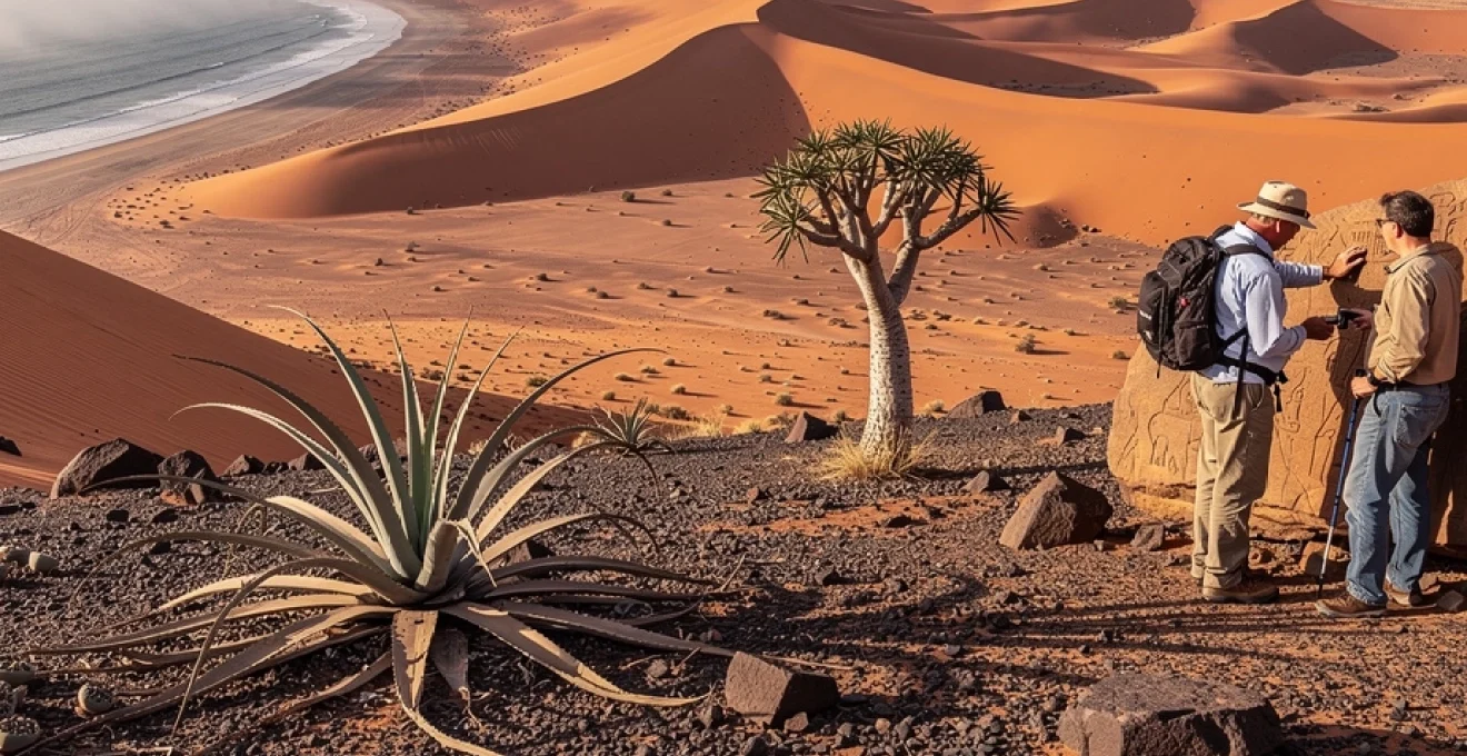
Archaeological evidence of human desert occupation at twyfelfontein
While Namibia’s deserts may appear empty at first glance, they have supported human life for tens of thousands of years. One of the most significant records of this long-term occupation is found at Twyfelfontein (officially known as ǀUi-ǁAis), a rocky valley in northwestern Namibia that contains one of Africa’s richest concentrations of prehistoric rock engravings. Designated a UNESCO World Heritage Site, Twyfelfontein offers compelling evidence that even in arid environments, humans have found ways to adapt, interpret, and celebrate their surroundings.
The engravings—estimated to be up to 5,000–6,000 years old—depict a wide variety of animals, including giraffes, rhinoceroses, lions, and antelope, as well as abstract geometric patterns and possible ritual symbols. Many researchers believe that these images were created by hunter-gatherer groups who used the valley as a seasonal base, taking advantage of local springs and game migrations. When you stand before these petroglyphs, etched into warm sandstone, you are connecting with generations of people who navigated the same desert landscapes that modern travellers explore today.
What can Twyfelfontein teach us about life in one of the world’s most unique desert landscapes? For one, it highlights how deeply intertwined people and environment have always been here. The careful selection of rock surfaces, the repeated depiction of certain animals, and the placement of engravings near water sources all suggest a sophisticated understanding of local ecology. Visiting with a knowledgeable guide can bring out these nuances, turning a walk through the valley into a journey through both human and environmental history.
Climate extremes and microhabitat diversity across namibian desert regions
Namibia’s deserts are often described as uniformly harsh, but in reality they encompass a surprising range of microclimates and microhabitats. Coastal zones shrouded in fog, inland gravel plains, highland plateaus, ephemeral river valleys, and dune seas all experience slightly different temperature regimes, moisture inputs, and wind patterns. These fine-scale differences, sometimes over just a few kilometres, allow for a patchwork of niches where specialised species can thrive. This is one of the key reasons Namibia is recognised as a biodiversity hotspot within seemingly monotonous arid terrain.
Temperature extremes can be dramatic, with daytime highs exceeding 40°C in summer and night-time lows near freezing in winter, especially in inland and elevated areas. Yet, ephemeral rivers such as the Kuiseb, Swakop, and Hoanib carve through the desert, creating narrow ribbons of comparatively lush habitat. Here, large mammals like desert-adapted elephants and lions can persist, moving along dry riverbeds in search of seasonal water and forage. For travellers planning to experience Namibia’s desert climate first-hand, understanding these regional variations can help you decide when and where to visit—perhaps timing a trip to see fog-laden mornings on the Skeleton Coast followed by clear, star-filled nights in the interior.
At the smaller scale, microhabitats such as south-facing slopes, shaded rock crevices, and clay pans offer slight advantages in moisture retention or reduced heat load. Many invertebrates, reptiles, and small mammals exploit these micro-refuges, emerging only at specific times of day or seasons. As you walk through these landscapes, you might ask yourself: how many different “worlds” exist within this one desert valley? By paying attention to subtle shifts in vegetation, soil type, and topography, you begin to see that Namibia’s deserts are not a single uniform environment but a mosaic of extreme yet intricately structured habitats.
For modern travellers, digital nomads, and researchers alike, this combination of climate extremes and microhabitat diversity is part of what makes Namibia’s desert regions so compelling. You can move from fog-cooled coastal dunes to sun-baked inland plains in a single day’s drive, experiencing different expressions of aridity along the way. In doing so, you gain a deeper appreciation not only of how life survives in one of the world’s most unique desert landscapes, but also of how finely balanced and precious these environments truly are.