# Best Transportation Options for Exploring Large Cities Like Los Angeles
Los Angeles presents a unique transportation challenge that differs dramatically from the compact, transit-oriented cities found across Europe and Asia. With over 500 square miles of urban sprawl spanning from the Pacific coastline to the San Gabriel Mountains, navigating this sprawling metropolis requires understanding a diverse ecosystem of mobility options. The city’s car-centric history has given way to an evolving landscape where rail networks, rideshare platforms, micromobility solutions, and traditional bus routes now coexist in an increasingly interconnected web of transportation alternatives.
Recent investments exceeding $120 billion in transit infrastructure have fundamentally transformed how residents and visitors experience Greater Los Angeles. The Metro Rail system has expanded to over 100 stations, whilst electric scooters and bike-share programmes have proliferated across neighbourhoods from Venice Beach to Pasadena. Understanding which transportation mode best suits your specific journey—whether you’re commuting from Santa Monica to Downtown or exploring the cultural corridors of Hollywood—can mean the difference between a seamless experience and hours lost to traffic congestion. The following analysis examines the practical realities of each major transportation category, providing the detailed insights you need to navigate LA’s complex mobility landscape effectively.
Metro rail system navigation: LA metro lines and station connectivity
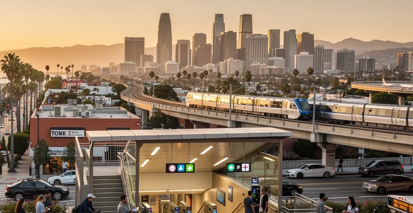
The Los Angeles Metro Rail network represents the backbone of the city’s public transportation infrastructure, comprising six distinct lines that collectively serve 101 stations across the metropolitan area. With over 300,000 daily riders, the system has grown substantially since its modern inception in 1990, though it still faces challenges inherent to retrofitting rapid transit into a city designed primarily for automobiles. The rail network offers significant advantages during peak traffic hours, when freeway travel times can stretch two to three times longer than off-peak journeys.
Fares remain remarkably affordable compared to other major American cities, with standard one-way trips costing just $1.75 and day passes available for $3.50. Unlike distance-based pricing models employed in systems like Washington DC’s Metro, LA’s flat-rate structure simplifies fare calculation regardless of journey length. However, you’ll quickly notice that coverage gaps persist in affluent areas such as Beverly Hills and Bel Air, where historical resistance to transit development has left residents dependent on private vehicles.
A line (blue) and E line (expo) coverage from downtown to santa monica
The E Line (Expo) stands as one of LA Metro’s most transformative additions, connecting Downtown Los Angeles to Santa Monica’s beaches in approximately 50 minutes—a journey that can take upwards of 90 minutes during rush hour traffic. This 15.6-mile corridor passes through culturally significant neighbourhoods including Culver City, where you’ll find access to the Culver City Arts District, and Exposition Park, home to the Natural History Museum and California Science Center. The line’s terminus at 4th Street/Colorado Avenue places you within walking distance of the Santa Monica Pier and Third Street Promenade.
Running parallel through much of South Los Angeles, the A Line (Blue) extends 22 miles from Downtown to Long Beach, serving areas that have historically faced transit inequity. Trains on both lines operate every 8-12 minutes during peak periods, though service frequency drops to 20-minute intervals during midday and evening hours. The A Line particularly serves as a vital commuter route for residents of Compton, Willowbrook, and other communities where car ownership rates remain below the county average of 89%.
B line (red) and D line (purple) routes through hollywood and Mid-Wilshire
The B Line (Red) functions as LA’s flagship subway route, travelling entirely underground from Union Station through the culturally iconic Hollywood and Highland district before terminating in North Hollywood. This 13.7-mile corridor serves some of the region’s highest-density employment centres, including the Civic Center governmental complex and the entertainment industry hub around Vine Street. You’ll find the Universal City/Studio City station provides direct access to Universal Studios Hollywood via a series of escalators climbing the Cahuenga Pass.
The D Line (Purple) currently shares trackage with the B Line from Union Station to Wilshire/Vermont before branching westward through the Mid-Wilshire corridor. Recent extensions have pushed the line progressively westward, with stations at
The Wilshire corridor’s extension, often referred to as the Metro D Line Extension, will ultimately take trains all the way to Westwood near UCLA, knitting together Downtown, Koreatown, the Miracle Mile museum district, Beverly Hills, and the Westside. For visitors, this means you can move from Union Station to cultural anchors like the Los Angeles County Museum of Art (LACMA) and the La Brea Tar Pits without touching a freeway. As construction phases open, expect journey times between Downtown and Westwood to drop to around 25 minutes, a game-changer compared with the often unpredictable 45–70 minutes by car. If your Los Angeles itinerary includes museums, gallery openings, or offices along Wilshire Boulevard, the D Line will quickly become your most time-efficient option.
TAP card integration and multi-modal transfer protocols
To make sense of Los Angeles’ complex transportation ecosystem, the TAP card (Transit Access Pass) is your essential tool. This reloadable smart card works across Metro Rail, Metro Bus, and most municipal bus systems in the county, including Culver CityBus, Big Blue Bus in Santa Monica, and LADOT DASH. Once you load stored value or a pass, you simply tap on the validator at station gates or bus fareboxes, and transfers between participating systems are calculated automatically within a 2-hour window. For multi-modal journeys—say, Metro E Line plus a DASH shuttle—the TAP system dramatically simplifies what would otherwise be a maze of different fare rules.
From a practical standpoint, you should treat your TAP card as a unified mobility wallet for big-city exploration. If you are combining Metro Rail with a bike-share trip or a municipal bus, planning your route in apps such as Transit or Google Maps lets you see how services line up in real time. Think of it as a digital “interchange” that allows you to switch between subway, light rail, and bus as easily as changing lanes on a highway. While not every small operator is fully integrated yet, coverage continues to expand, and for most visitors you can rely on TAP for the majority of urban transportation in Los Angeles.
Multi-modal transfers also have a strategic value when you are trying to avoid surge pricing on rideshare platforms. Rather than booking an end-to-end car trip from Santa Monica to Downtown, you can rideshare to a nearby rail station, tap in on the E Line, then switch back to a short rideshare hop at your destination. This “first and last mile” approach leverages the flat Metro fare and can cut your overall cost by half, particularly during peak tourism periods and major events. If you are visiting multiple large cities in the U.S., learning how LA’s TAP-based transfers work will also make it easier to adapt to similar smart card systems elsewhere.
Peak hour frequency and off-peak service limitations
Like most major urban rail networks, the LA Metro system is calibrated around peak commuting patterns. During weekday rush hours—typically 6:30–9:30 a.m. and 3:30–7:00 p.m.—core lines such as the B, D, and E often run every 6–10 minutes, which makes them highly competitive with driving on congested freeways. If you are planning to use Metro Rail as your primary mode of transportation, aligning major trips with these high-frequency windows can turn what might be a stressful highway slog into a predictable, air-conditioned ride. The trade-off is that trains can be busy at these times, especially through central nodes like 7th Street/Metro Center, but crowding rarely reaches the crush levels seen in older systems like New York or Tokyo.
Off-peak, evenings, and weekends tell a different story. Service intervals on many lines stretch to 12–20 minutes, and late-night frequencies can drop further, particularly after 10 p.m. This does not mean you cannot rely on Metro at these times, but it does require more deliberate planning and a willingness to build a buffer into your schedule. If you are catching a late show in Hollywood or returning from Santa Monica after dinner, checking the live timetable in an app before you leave can help you avoid long platform waits. In big, spread-out cities like Los Angeles, off-peak rail still beats crawling through late-night lane closures on the freeway, but you will want a backup option—such as rideshare or a night bus route—if you are on a tight timeline.
Rideshare platform comparison: uber, lyft and alto in greater los angeles
For many visitors, rideshare platforms function as the connective tissue that fills gaps between rail lines, bus routes, and walkable districts. In Greater Los Angeles, Uber and Lyft dominate the market, with coverage extending from Malibu to Anaheim and from Santa Clarita to Long Beach. Alto, a newer premium service, operates a smaller fleet but differentiates itself with company-owned vehicles, uniformed drivers, and a more controlled in-car experience. Choosing between these rideshare options in a large city like Los Angeles is less about brand loyalty and more about matching your budget, comfort expectations, and timing needs to real-time conditions on the ground.
Cost structures between Uber and Lyft are broadly similar, with base fares, per-mile, and per-minute components plus additional fees. Alto typically prices higher per trip but markets itself as a predictably priced, membership-based alternative with fewer surprises during demand spikes. In practice, savvy travelers will often check at least two apps before confirming a ride, particularly for longer trips along major corridors like the 405 or 101. Think of it like checking multiple airlines for a flight: in a large and dynamic market such as LA, small differences in algorithmic pricing can translate into sizeable savings over the course of a week-long visit.
Surge pricing patterns along sunset boulevard and PCH corridors
Surge pricing is arguably the most misunderstood aspect of rideshare transportation in big cities like Los Angeles. Rather than being random, price spikes reflect predictable patterns of supply and demand. Along high-profile corridors such as Sunset Boulevard in West Hollywood and the Pacific Coast Highway (PCH) through Santa Monica and Malibu, surges tend to cluster around nightlife peaks, beach days, and major events. Friday and Saturday evenings, especially between 8 p.m. and 2 a.m., see regular surges in the entertainment districts of Hollywood, West Hollywood, and Downtown, where thousands of people often request cars simultaneously.
On sunny weekends and holidays, PCH can become a textbook case of demand outstripping supply, as both locals and tourists exit the beaches at similar times. In these moments, you may see multipliers of 1.5x to 2.5x for standard rides, with even higher peaks during special events or sudden weather changes. Want to avoid getting caught in this pricing trap? Consider using Metro to reposition yourself to a less congested pickup area, or wait 10–15 minutes to see if the surge decays as idle drivers move into the zone. Just as seasoned airline travelers know to avoid flying at peak holiday times, experienced rideshare users in Los Angeles learn to time their departures strategically to dodge the sharpest price spikes.
Airport queue systems at LAX and bob hope burbank airport
Airports in major metropolitan areas operate under unique constraints, and Los Angeles is no exception. At LAX, Uber, Lyft, and similar services use a virtual queue system combined with designated pickup zones at the LAX-it lot for most terminals. Rather than circling the airport, drivers wait in a geo-fenced holding area and are dispatched when you place a request, while passengers take a shuttle from their terminal to the pickup zone. This system has improved overall traffic flow, but it also means you should budget an extra 15–30 minutes from baggage claim to vehicle boarding, especially during busy travel periods.
Bob Hope Burbank Airport (officially Hollywood Burbank Airport) offers a more compact, user-friendly experience. Rideshare pickups are usually located just outside the terminal area, and virtual queues tend to move faster due to lower overall demand. For travelers staying in Hollywood, Glendale, or the San Fernando Valley, Burbank can be a strategic alternative to LAX, both in terms of flight schedules and ground transportation. Regardless of airport, it is wise to compare rideshare and taxi pricing at the curb—short hops to nearby hotels can sometimes be cheaper in a traditional cab, while longer cross-city journeys favor rideshare, especially when no surge is in effect.
Shared ride algorithms for venice beach to downtown commutes
Shared rides—such as UberX Share or Lyft Shared—use algorithms to match riders with similar routes, reducing per-person costs and vehicle miles traveled. On popular corridors like Venice Beach to Downtown Los Angeles, these algorithms have plenty of data and rider volume to optimize matching, especially during commuting hours. If you are traveling solo and not in a rush, opting for a shared ride can cut your fare significantly compared with a private car, while still dropping you near your destination. In a city famous for its traffic, this can feel like joining an informal carpool that you did not have to organize yourself.
However, shared rides introduce additional variables that you need to factor into your planning. Extra pickups and drop-offs can add 10–25 minutes to your journey, and detours may take you on less direct routes through neighborhoods like Palms, Culver City, or Pico-Union. Think of a shared ride as the midpoint between a city bus and a private taxi: you get some of the cost efficiency of transit with more comfort and flexibility, but you sacrifice speed and predictability. When precision matters—for example, catching a specific train at Union Station—stick with a solo ride or combine Metro Rail with a short rideshare segment for the most reliable overall timing.
Electric scooter and bike-share infrastructure across LA neighbourhoods
Micromobility—electric scooters and shared bikes—has become a defining feature of transportation in many large cities, and Los Angeles is no exception. Scooters from Bird, Lime, and Wheels, along with Metro Bike Share and local services, offer a nimble way to cover the “last mile” between a rail station and your final destination. For short trips under two miles in dense neighborhoods, these options can often be faster than driving and parking, especially when streets are congested. The key is understanding where these vehicles are allowed, where they are plentiful, and what rules govern their use.
Because Greater Los Angeles is a patchwork of municipal jurisdictions, micromobility rules and availability can change abruptly as you cross city boundaries. One block may be filled with scooters ready to ride; the next may be an enforced no-ride or no-parking zone. To navigate this effectively, always check the in-app map before you start a trip and zoom in on your destination area to make sure you can end the ride legally. In many ways, using scooters and bike-share here is like sailing between small islands: each city has its own harbor rules, and it pays to know them before you set off.
Bird, lime and wheels deployment zones in santa monica and west hollywood
Santa Monica was one of the earliest U.S. cities to see large-scale deployment of shared scooters, and today it remains one of the most scooter-friendly environments in Los Angeles County. Bird and Lime maintain dense clusters of vehicles around Downtown Santa Monica, the Expo Line terminus, and residential neighborhoods north and south of Wilshire Boulevard. This makes it easy to step off a train and grab a scooter to reach the beach, the Pier, or hotels along Ocean Avenue. Santa Monica’s clear signage and dedicated bike lanes further improve safety and usability, making it an ideal testing ground if you are new to scooters.
West Hollywood has also embraced micromobility, with Bird, Lime, and Wheels operating under structured permit systems. Deployment tends to concentrate along major corridors like Santa Monica Boulevard and Sunset Boulevard, connecting nightlife, retail, and residential areas. Because West Hollywood is relatively compact and walkable, scooters function as a convenient “speed boost” rather than a replacement for transit, letting you string together multiple venues in one evening without battling for curbside parking. As in any dense urban area, you should ride defensively, stay off sidewalks where prohibited, and always park neatly to avoid blocking doorways or ramps.
Metro bike share docking stations in downtown LA and pasadena
For those who prefer the stability and predictability of docked systems, Metro Bike Share provides a robust bike network in Downtown Los Angeles, the Arts District, Koreatown, and extending into Pasadena. Unlike free-floating scooters, these bikes must be picked up and returned to designated docking stations, which reduces clutter and guarantees that parking is always legal when a dock is available. In Downtown, docks are strategically placed near major office towers, cultural institutions, and Metro Rail stations such as Union Station, 7th Street/Metro Center, and Pico.
Pasadena’s extension of the Metro Bike Share network opens up a different style of exploration, blending urban and suburban environments. You can, for example, take the A Line to Memorial Park Station and then hop on a bike to visit the Rose Bowl, Old Pasadena, or local campuses. For visitors, one of the best strategies is to plan loops that begin and end at the same dock to avoid anxiety about finding space at your destination. If you are used to dockless systems in other large cities, Metro Bike Share’s structured approach can feel a bit more constrained but also more reliable, particularly during special events when demand spikes.
Cycle lane networks along ballona creek and LA river pathways
Los Angeles may be known for its freeways, but it also offers extensive off-street bike paths that can transform how you experience the city. The Ballona Creek Bike Path, for instance, runs east–west from Culver City toward Marina del Rey, providing a largely car-free route that links inland neighborhoods to the coast. Similarly, segments of the LA River Path in areas like the Glendale Narrows and Elysian Valley offer scenic, low-stress cycling away from arterial traffic. For longer recreational rides or environmentally friendly commutes, these corridors function like bicycle expressways through the urban fabric.
When you overlay these cycle routes with Metro Rail and bus lines, new possibilities appear for car-free exploration across wide areas of the Los Angeles Basin. You might ride a shared bike along Ballona Creek to the E Line, then take the train into Downtown, or use the LA River Path in combination with the B Line to reach creative districts and breweries in the Valley. Compared with surface streets, these dedicated paths feel almost like secret back doors into the city, letting you bypass bottlenecks and enjoy uninterrupted motion. Just remember that lighting and activity levels can drop after dark, so daytime rides are generally advisable unless you are very familiar with the area.
Geofencing restrictions in beverly hills and restricted parking zones
Not all neighborhoods in Los Angeles welcome scooters and shared bikes with equal enthusiasm. Beverly Hills, in particular, has implemented strict regulations and geofencing that effectively prohibit scooter operation and parking within city limits. If you ride a Bird or Lime toward Beverly Hills, your app will typically warn you before you enter a no-ride zone, and the scooter may slow or stop as you cross the boundary. Similar restrictions can appear around certain campuses, shopping centers, or residential complexes that have opted out of micromobility deployments.
From a user perspective, these geofenced zones create invisible walls that you must account for when planning routes. Picture them like toll booths on a highway that you cannot pass without turning around; ignoring them can result in fines or account penalties if you abandon a device in a prohibited area. To stay on the right side of local rules, always end your trip within the approved service area displayed in your app and take a moment to confirm that parking is legal and considerate. In a multi-jurisdictional region like Greater Los Angeles, respecting these digital borders is just as important as obeying physical traffic signs.
Car rental services for long-distance LA basin exploration
Despite the growth of public transportation and micromobility, renting a car remains the most flexible option for exploring the wider Los Angeles Basin and beyond. If your plans include day trips to Malibu, the San Gabriel Mountains, Disneyland, or Joshua Tree, you will quickly discover that rail and bus networks thin out as you move away from the urban core. Major rental brands cluster around LAX, Burbank, and Union Station, but smaller neighborhood rental offices in Hollywood, Westwood, and Santa Monica can be more convenient if you only need a vehicle for specific days. Booking in advance, particularly around holidays and large conferences, helps avoid last-minute price spikes and limited inventory.
When evaluating whether car rental makes sense for your stay, weigh the total cost of ownership—daily rate, insurance, fuel, parking, and potential tolls—against what you would spend on rideshare and transit. For a solo traveler staying mostly in central LA neighborhoods, rideshare plus Metro Rail is often cheaper and less stressful than renting a car. For families or small groups, however, a rental can become cost-effective very quickly, especially when you factor in the convenience of carrying luggage, beach gear, or hiking equipment. As in any large city, parking strategies matter: look for hotels that include parking or offer discounts, and use apps to locate public garages near attractions so you are not circling crowded streets in unfamiliar areas.
DASH and municipal bus routes for hyperlocal neighbourhood transit
Beyond the region-wide Metro system, Los Angeles is served by a patchwork of municipal bus operators that specialize in short, neighborhood-focused routes. LADOT’s DASH services are among the most useful for visitors, offering low-cost circulator routes through Downtown, Hollywood, Echo Park, and other dense districts. Fares are typically lower than standard Metro buses, and frequencies can be surprisingly high on popular loops, making DASH buses an ideal option for hopping between sightseeing spots without breaking your budget. Because many routes are less than five miles end to end, travel times remain manageable even in heavy traffic.
Other cities within the Los Angeles area operate their own systems—such as Santa Monica’s Big Blue Bus, Culver CityBus, and Glendale Beeline—that connect residential areas to major job centers and rail stations. For example, Big Blue Bus routes link the E Line terminus in Santa Monica with UCLA, Brentwood, and Venice, filling notable gaps in rail coverage. If you think of Metro Rail as the skeleton of regional mobility, these municipal buses are the muscles and tendons that move you to specific addresses. Planning tools like Google Maps and Transit integrate most of these networks, so you can design door-to-door itineraries that combine local buses with subways, light rail, or even bike-share when appropriate.
Emerging autonomous vehicle pilots in santa monica and culver city
Los Angeles is also a proving ground for emerging mobility technologies, including autonomous vehicle (AV) pilots in areas like Santa Monica and Culver City. While still limited in scope and often operating under testing or early commercial phases, these driverless shuttles and ride services hint at how future big-city transportation might function. Some pilots operate on fixed routes between transit hubs and business districts, while others provide on-demand rides within geo-fenced zones during specific hours. For now, you are more likely to encounter AVs as a curiosity than as a primary transportation option, but their presence is steadily growing.
What does this mean for you as a visitor or resident? In the short term, AV pilots offer an opportunity to experience cutting-edge mobility in a relatively controlled environment, often at promotional or subsidized fares. They can also serve as a useful supplement to more traditional modes, particularly for last-mile connections in innovation-focused districts. Looking further ahead, successful pilots in Santa Monica and Culver City may influence how autonomous shuttles and robo-taxis are deployed in other large cities, shifting the balance between private car ownership, ridesharing, and public transit. By paying attention to these experiments now, you gain insight into how urban transportation in Los Angeles—and beyond—will continue to evolve over the next decade.