Africa presents some of the most breathtaking and geologically diverse landscapes on Earth, where ancient forces have sculpted extraordinary terrains that continue to captivate adventurous travelers. From the volcanic craters of East Africa to the sweeping sand dunes of the Sahara, the continent offers an unparalleled collection of natural wonders that showcase millions of years of geological evolution. These remarkable destinations provide opportunities to witness active volcanic activity, explore deep canyon systems, and experience unique ecosystems that exist nowhere else on the planet.
The continent’s geological diversity stems from its position at the intersection of multiple tectonic plates, creating dramatic rift valleys, towering mountain ranges, and expansive desert systems. Travelers seeking extraordinary landscapes will discover that Africa’s natural attractions extend far beyond traditional safari experiences, offering encounters with some of the most spectacular geological formations found anywhere in the world.
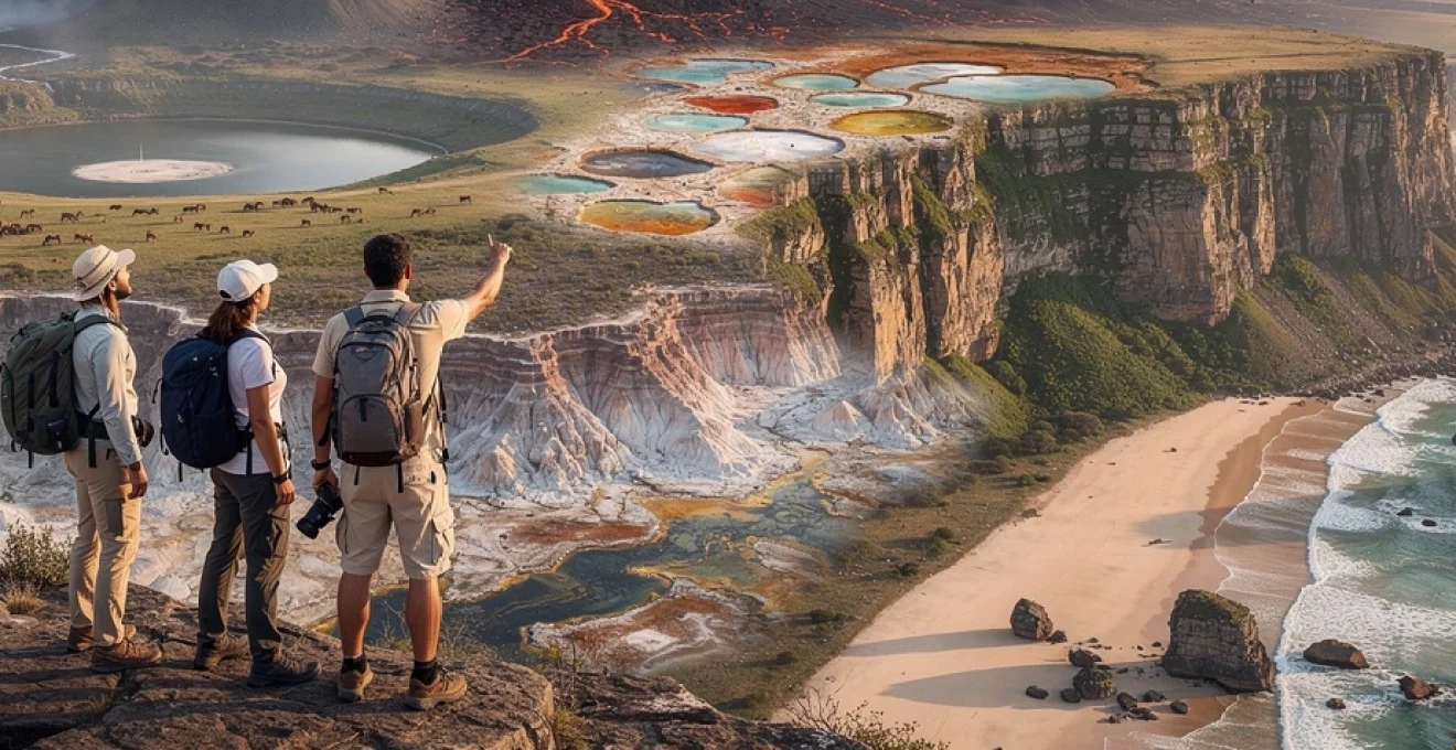
Volcanic geological formations and crater landscapes across east africa
East Africa’s position along the Great Rift Valley has created a remarkable concentration of volcanic landscapes and crater formations that attract geologists and adventure travelers from around the globe. The region’s volcanic activity continues to shape these landscapes today, offering visitors the rare opportunity to witness active geological processes in some of the world’s most accessible locations.
Ngorongoro crater conservation area: ancient caldera ecosystems in tanzania
The Ngorongoro Crater stands as one of Africa’s most iconic geological features, representing the world’s largest intact volcanic caldera. This massive crater, measuring approximately 20 kilometers in diameter, was formed roughly 2.5 million years ago when a giant volcano collapsed upon itself, creating a natural amphitheater that now hosts one of the most concentrated wildlife populations on the continent. The crater floor sits at an elevation of 1,800 meters, surrounded by steep walls that rise 600 meters above the caldera floor.
Within this ancient volcanic bowl, visitors encounter a unique ecosystem where grasslands, forests, and alkaline lakes create distinct microclimates. The permanent water sources, including Lake Magadi with its distinctive pink flamingo populations, support an estimated 25,000 large mammals throughout the year. The geological significance of this formation extends beyond its wildlife value, as the crater walls preserve layers of volcanic ash and sediment that provide insights into millions of years of East African climate history.
Mount nyiragongo active volcano crater lake in democratic republic of congo
Mount Nyiragongo presents one of the most spectacular and accessible active volcano experiences available to travelers worldwide. This stratovolcano, rising 3,470 meters above sea level, contains the world’s largest lava lake within its 1.2-kilometer-wide crater. The permanent lava lake, which has persisted for decades, creates a mesmerizing display of molten rock that glows dramatically against the night sky, offering photographers and adventure seekers an extraordinary natural spectacle.
The trek to Nyiragongo’s summit typically requires a full day of hiking through montane forest zones, where visitors can observe the transition from tropical vegetation to alpine conditions. The volcanic activity at Nyiragongo remains closely monitored, as the volcano has experienced significant eruptions in recent decades, most notably in 2002 when lava flows reached the nearby city of Goma. Despite these risks, guided expeditions to the crater rim provide one of the most thrilling geological experiences available to civilian travelers.
Danakil depression hydrothermal fields and salt formations in ethiopia
The Danakil Depression represents one of Earth’s most extreme and otherworldly landscapes, where active hydrothermal processes create surreal formations that challenge conventional perceptions of natural beauty. Located at the junction of three tectonic plates, this geological wonder sits at 125 meters below sea level, making it one of the lowest and hottest places on Earth, with temperatures regularly exceeding 50°C during daylight hours.
Visitors to the Danakil Depression encounter a landscape dominated by sulfur springs, salt pillars, and colorful mineral deposits that create an almost alien environment. The hydrothermal fields at Dallol produce vivid yellow, green, and orange formations as sulfur-rich waters interact with salt deposits and volcanic minerals. These formations continuously evolve as underground
geothermal fluids rise to the surface, depositing new layers of salt and minerals each day. For travelers, visiting this hydrothermal field feels like walking across a vivid, living laboratory of plate tectonics and extreme chemistry. Access to the Danakil Depression is tightly controlled due to its harsh conditions and proximity to international borders, so journeys are typically arranged as multi-day expeditions with experienced guides, armed escorts, and support vehicles. While the environment is unforgiving, those who are well prepared and travel with reputable operators are rewarded with one of the most extraordinary landscapes in Africa, combining geological insight with an unforgettable sense of remoteness.
Erta ale shield volcano permanent lava lakes in afar region
Erta Ale, located in Ethiopia’s Afar Region, is one of the few volcanoes on Earth that has maintained a persistent lava lake for decades. This low, broad shield volcano rises modestly above the surrounding desert, yet it hosts one of the planet’s most dramatic windows into Earth’s molten interior. At its summit, a series of craters contains active vents where lava wells up, cools, and fractures in constant motion, producing a hypnotic display of glowing magma, volcanic gases, and crustal plates that resemble a burning mosaic.
Reaching Erta Ale typically involves a long drive across lava fields and salt plains, followed by a night hike to the crater rim. Conditions are basic and often challenging, with heat, dust, and minimal infrastructure, so this is a destination best suited to experienced adventure travelers who are comfortable outside traditional comfort zones. Yet the reward is unparalleled: standing on the edge of a lava lake at night, you can observe the Earth’s crust being born in real time, an experience that explains why Erta Ale is high on many bucket lists for travelers seeking extraordinary landscapes in Africa.
Sandstone rock formations and desert escarpments in southern africa
Southern Africa offers a contrasting portfolio of extraordinary landscapes, where sandstone cliffs, basalt massifs, and deep gorges reveal millions of years of erosion and uplift. These dramatic escarpments and canyons provide a different perspective on Africa’s geological story compared with its volcanic regions, yet they are no less compelling. For hikers, photographers, and self-drive explorers, this is a region where every bend in the road reveals another sweeping viewpoint or sculpted rock formation.
Drakensberg amphitheatre basalt cliffs and tugela falls in south africa
The Drakensberg mountain range in South Africa is one of the continent’s most visually arresting highland areas, and the Amphitheatre is its most iconic feature. This vast wall of basalt cliffs stretches for about 5 kilometers, with near-vertical faces that rise over 1,200 meters from the valley floor. At its edge, Tugela Falls cascades down a series of drops that together are often ranked among the tallest waterfalls in the world, particularly impressive after summer rains when the flow is strongest.
For travelers, the Drakensberg offers a rare combination of accessible hiking, dramatic scenery, and cultural heritage, including ancient San rock art in nearby caves. Well-marked trails lead to viewpoints of the Amphitheatre, while more demanding routes allow experienced trekkers to reach the escarpment top or even camp along the plateau. Because the region sits at elevation, weather can change quickly, so packing layers and checking local conditions is essential if you plan to explore these basalt cliffs and highland landscapes on foot.
Fish river canyon sedimentary rock strata in namibia
Namibia’s Fish River Canyon is often described as Africa’s answer to the Grand Canyon, and with good reason. Carved over hundreds of millions of years by tectonic uplift and river erosion, this immense chasm stretches about 160 kilometers in length, up to 27 kilometers in width, and plunges as deep as 550 meters. Layer upon layer of exposed sedimentary and metamorphic rock create a cross-section of Earth’s history, visible in the canyon walls like the pages of an open geological book.
Most visitors experience Fish River Canyon from its easily accessible viewpoints along the rim, particularly at sunrise and sunset when the angled light intensifies the orange and purple hues of the rock strata. For those seeking a more immersive adventure, the multi-day Fish River Canyon hiking trail descends into the canyon floor and follows the riverbed through a landscape of boulders, hot springs, and sculpted cliffs. This trek is only open in the cooler months and requires a good level of fitness, self-sufficiency, and advance permits, but it offers one of southern Africa’s most rewarding wilderness experiences.
Augrabies falls granite gorge formation along orange river
Augrabies Falls, also in southern Africa, showcases how water can carve through some of the planet’s toughest rocks. Here, the Orange River plunges approximately 56 meters into a narrow granite gorge, creating a thunderous waterfall that locals refer to as “the place of great noise.” Over time, the river has exploited fractures in the granite bedrock, deepening and narrowing the chasm into a dramatic, polished corridor lined with steep, almost vertical walls.
Augrabies Falls National Park offers a series of viewing platforms and short walking trails along the gorge, allowing you to appreciate both the raw power of the river and the intricate patterns etched into the granite. In the surrounding semi-desert, unusual quiver trees and rock hyraxes cling to the rocky slopes, adding ecological interest to the geological spectacle. Conditions can be extremely hot in summer, so planning a visit in the cooler months or exploring early in the morning and late afternoon will make the experience more comfortable and allow better photography of the canyon’s textures.
Blyde river canyon quartzite and shale geological structures
Blyde River Canyon in South Africa’s Mpumalanga province is another standout destination for travelers pursuing extraordinary landscapes in Africa. Often cited as one of the world’s largest “green canyons” due to its lush vegetation, Blyde is carved primarily into resistant quartzite and underlying shale. This combination has produced steep cliffs, rounded buttresses, and layered rock formations that form viewpoints with evocative names, such as the Three Rondavels and God’s Window.
The canyon’s geological story is intertwined with the broader evolution of the Drakensberg escarpment and the ancient supercontinent of Gondwana. Today, self-drive routes and short walks link multiple viewpoints along the canyon rim, making it easy to experience big scenery in a relatively compact area. If you prefer a more active visit, boat trips on the Blyde Dam or guided hikes along the escarpment provide alternative perspectives on the quartzite cliffs, waterfalls, and forested slopes that define this spectacular South African landscape.
Coastal marine terraces and limestone karst topography
Africa’s coastlines offer far more than sandy beaches; they also conceal complex geological stories involving fluctuating sea levels, coral growth, and tectonic uplift. From dune-backed archipelagos to wave-cut cliffs and fossil coral terraces, these coastal formations showcase how oceans and continents interact over vast time scales. For travelers, they provide a rich blend of snorkeling, coastal hiking, and scenic boat trips, all set against some of the most extraordinary landscapes in Africa.
Bazaruto archipelago dune systems and coral reef formations in mozambique
The Bazaruto Archipelago off Mozambique’s southern coast is a prime example of a dynamic coastal landscape where wind, waves, and coral growth work together to shape the environment. The islands are dominated by shifting dune systems that can rise over 100 meters, their golden sands constantly reworked by prevailing winds. Beneath the surface, extensive coral reefs and seagrass beds host a wealth of marine life, including manta rays, turtles, and one of the last viable populations of dugongs in the western Indian Ocean.
For visitors, Bazaruto’s appeal lies in this fusion of desert-like dunes and clear turquoise waters, a contrast that few other destinations can match. You can climb the highest dunes at sunrise for sweeping views across the archipelago, then spend the rest of the day snorkeling or diving along protected reefs where visibility often exceeds 20 meters. Because Bazaruto is a designated marine national park, tourism is managed to reduce environmental impact, and working with licensed operators helps ensure that your visit supports ongoing conservation initiatives.
Tsitsikamma marine protected area cliff formations in south africa
Along South Africa’s famed Garden Route, the Tsitsikamma Marine Protected Area combines rugged coastal geology with rich marine ecosystems. Here, ancient sedimentary rocks have been tilted, folded, and fractured, creating a dramatic series of cliffs, sea caves, and wave-cut platforms that drop steeply into the Indian Ocean. The pounding surf has sculpted arches and narrow inlets, while rivers descending from the inland plateau carve deep gorges through the coastal terrace before meeting the sea.
The popular Otter Trail and shorter day hikes from Storms River Mouth allow travelers to experience these cliff formations at close range, often with suspension bridges spanning chasms and viewpoints perched above crashing waves. Below the surface, cold-water upwellings support thriving kelp forests and diverse fish populations, making this a rewarding destination for snorkeling and scuba diving. If you enjoy combining geology with high-energy coastal scenery, Tsitsikamma is one of the best destinations in Africa for dramatic seascapes and outdoor adventure.
Skeleton coast shipwreck graveyard and desert-ocean interface in namibia
Namibia’s Skeleton Coast is a haunting yet beautiful stretch of shoreline where the Namib Desert meets the Atlantic Ocean. Strong currents, shifting fog banks, and treacherous sandbanks have historically made navigation difficult here, leading to numerous shipwrecks that now dot the coast. These rusting hulls and skeletal remains, half-buried in sand, provide a stark reminder of the power of wind and waves along this desert-ocean interface.
Geologically, the Skeleton Coast is fascinating because it showcases how one of the world’s oldest deserts interacts with a cold, nutrient-rich ocean. Sand dunes march almost to the high-tide line, while coastal erosion and deposition continually reshape the shoreline. Access is tightly regulated through national park permits or fly-in lodges, which helps protect fragile habitats, including seal colonies and rare desert-adapted wildlife. For travelers who appreciate stark, minimalist landscapes and a profound sense of isolation, this is one of Africa’s most compelling coastal regions.
Diani beach coral rag limestone formations in kenya
On Kenya’s south coast, Diani Beach is best known for its palm-fringed sands and turquoise waters, but its underlying geology is equally interesting. The coastal plateau here is formed from fossilized coral rag limestone, a porous rock created by ancient reef systems that have since been uplifted and exposed. Over time, rainwater and wave action have carved small overhangs, tide pools, and cave systems into the limestone, while living coral reefs continue to grow offshore.
Travelers exploring Diani can see evidence of this coral rag in the low cliffs behind the beach and in traditional building materials used in local villages. Snorkeling and diving trips reveal how today’s coral communities are gradually forming the next generation of limestone, a slow-motion process that mirrors earlier geological epochs. Because coastal development can threaten both limestone stability and reef health, choosing accommodations and operators with strong environmental practices is an effective way to help protect this unique stretch of Kenya’s shoreline.
Saharan sand dune systems and oasis microclimates
When you picture extraordinary landscapes in Africa, chances are the Sahara’s rolling dunes come to mind. This vast desert, covering about 9 million square kilometers, is home to some of the tallest and most photogenic dune systems on Earth, shaped by wind patterns that have shifted for thousands of years. While the outline of the Sahara’s best-known dune fields in Algeria, Morocco, and Tunisia could each warrant their own sections, they share common features that make them outstanding destinations for landscape-focused travelers.
In major ergs such as Erg Chebbi in Morocco or the Grand Erg Oriental in Algeria, dunes can exceed 150 meters in height, forming sinuous ridges that change color from pale gold to deep orange as the sun moves across the sky. Between dune seas, rocky plateaus and gravel plains create stark contrasts, while isolated oases such as those near Siwa or Timimoun support microclimates where date palms, crops, and small communities thrive. Visiting these regions often involves camel treks or 4×4 journeys, with nights spent under star-filled skies that offer exceptional stargazing due to minimal light pollution.
Because desert environments are fragile and prone to erosion, responsible travel practices are especially important here. Sticking to established routes, minimizing off-track driving, and supporting local guides and camps help preserve delicate dune systems and sustain oasis communities. If you are fascinated by patterns, light, and texture, the Sahara’s sand seas and oasis belts provide an endlessly changing canvas for photography and quiet contemplation.
Great rift valley tectonic landscapes and alkaline lake systems
The Great Rift Valley is one of the defining geological features of East Africa, stretching more than 6,000 kilometers from the Red Sea to Mozambique. Formed by the gradual pulling apart of tectonic plates, the valley consists of fault-bounded escarpments, volcanoes, and deep basins that now host a chain of lakes. For travelers seeking extraordinary landscapes in Africa, this region offers a compact showcase of rifting processes, from steaming geothermal vents to shimmering alkaline lakes crowded with flamingos.
In Kenya and Tanzania, Rift Valley lakes such as Nakuru, Bogoria, Manyara, and Natron are especially famous for their soda-rich waters and vibrant birdlife. Alkaline conditions, driven by high evaporation and limited outflow, encourage blooms of microscopic algae that tint the lakes in shades of pink and green and provide food for millions of lesser and greater flamingos. Around the lake margins, you can often see hot springs, travertine terraces, and fresh fault scarps that highlight ongoing tectonic activity in the region.
Beyond the lakes, the Rift Valley’s steep escarpments offer panoramic viewpoints that reveal how dramatically the landscape has been pulled apart over geological time. Towns like Naivasha or Karatu make practical bases for exploring nearby crater lakes, geothermal fields, and wildlife reserves set within the rift. Because some lakes experience significant fluctuations in water levels due to climate variability and land-use changes, visiting different sites along the valley can also provide insight into how East Africa’s landscapes are responding to modern environmental pressures.
Highland plateau ecosystems and montane forest biodiversity zones
Africa’s highland plateaus add yet another dimension to the continent’s portfolio of remarkable landscapes. From the Ethiopian Highlands to the Afro-montane belts of East and southern Africa, these elevated regions act like islands in the sky, hosting cooler climates and ecological communities distinct from surrounding lowlands. For travelers, they offer refreshing temperatures, sweeping vistas, and the chance to explore montane forests that rank among the world’s richest biodiversity zones.
In Ethiopia, the central plateau rises above 2,000 meters in many areas, with peaks surpassing 4,000 meters in the Simien and Bale Mountains. Here, dramatic escarpments drop hundreds of meters into valleys, while high-altitude grasslands and cloud forests support endemic species such as the gelada baboon, Ethiopian wolf, and walia ibex. Well-established trekking routes and eco-lodges make it possible to combine multi-day hikes with cultural encounters in traditional highland villages, where terraced fields and stone churches cling to the slopes.
Across East and southern Africa, other highland massifs such as Mount Kenya, the Rwenzori Mountains, and Malawi’s Nyika Plateau exhibit similar patterns of vertical zonation, with forest belts giving way to moorlands and rocky summits. These montane ecosystems act as crucial water towers for surrounding regions, capturing rainfall and feeding major river systems that support millions of people downstream. When you walk through mist-draped forests filled with giant lobelias, tree ferns, and endemic birds, it becomes clear why conservation of these highland plateaus is so important—not only for biodiversity, but also for the long-term resilience of Africa’s landscapes and communities.