Standing at the precipice where land meets sea, coastal cliff hiking represents one of nature’s most dramatic theatre stages. These towering geological formations, sculpted by millennia of wind and wave action, offer hikers an unparalleled combination of physical challenge, ecological diversity, and breathtaking vistas that extend to the horizon. From the vertiginous chalk faces of Dover to the volcanic pali of Hawaii, coastal cliff trails attract millions of adventurers annually, each seeking that visceral connection between earth, ocean, and sky.
The appeal of coastal cliff hiking transcends mere scenery. These routes traverse some of the planet’s most dynamic ecosystems, where marine and terrestrial environments collide to create unique habitats for specialist flora and fauna. Whether you’re navigating the Atlantic-battered headlands of Ireland or descending switchbacks carved into Norwegian fjord walls, each coastal cliff system presents distinct geological characteristics, weather patterns, and access considerations that demand careful preparation and respect for the environment.
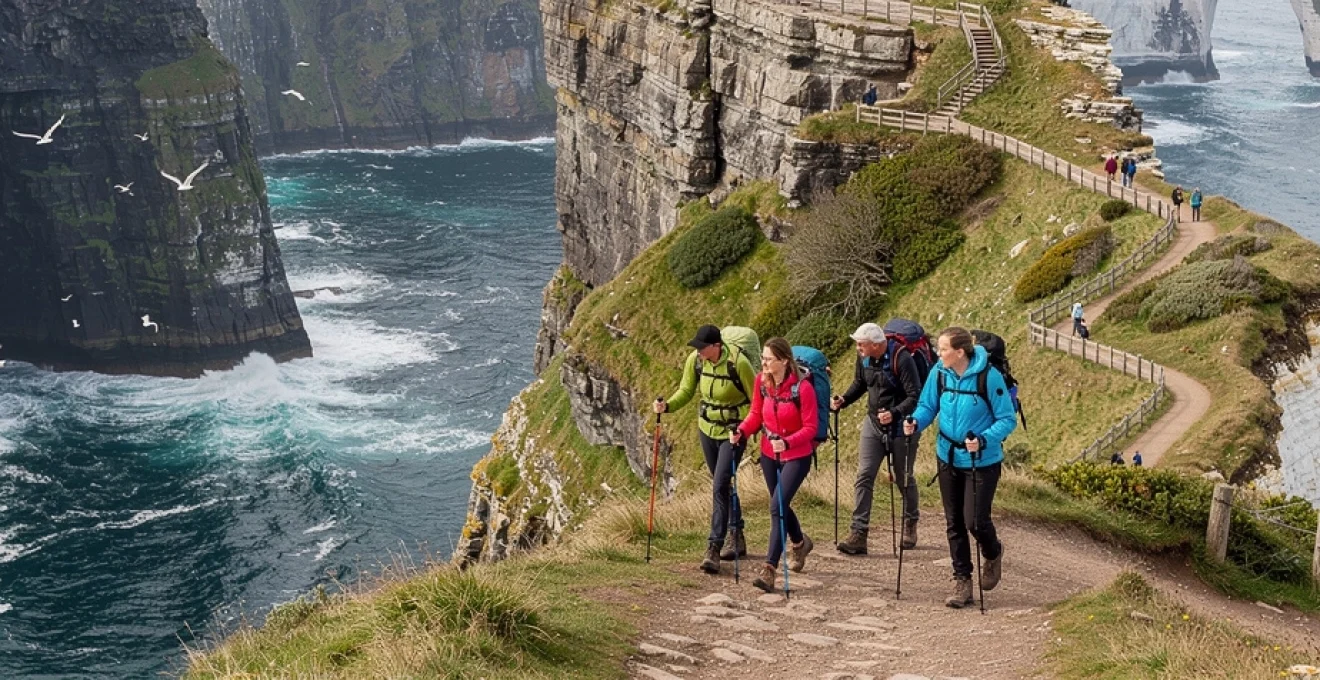
Moher cliffs trail system: navigating ireland’s 214-metre vertical atlantic edge
The Cliffs of Moher represent Ireland’s most visited natural attraction, drawing over 1.5 million visitors annually to County Clare’s western coastline. Rising 214 metres at their highest point near O’Brien’s Tower, these dramatic formations extend for approximately 14 kilometres along the Atlantic coast, offering hikers an extraordinary encounter with Ireland’s geological past. The sedimentary layers visible in the cliff faces chronicle some 300 million years of earth history, predominantly consisting of Namurian shale and sandstone deposited during the Upper Carboniferous period.
The formal cliff-edge pathway spans from Doolin village in the north to Hag’s Head in the south, providing varying levels of access for different fitness capabilities. The most popular section runs from the visitor centre to O’Brien’s Tower, a relatively gentle 800-metre walk on paved surfaces that accommodates wheelchairs and pushchairs. However, the full cliff walk presents a more challenging undertaking, requiring 4-5 hours and traversing uneven terrain, stiles, and exposed sections where Atlantic gales can reach dangerous velocities.
Weather conditions at Moher fluctuate dramatically, sometimes within the same hour. The exposed clifftop location experiences Atlantic depressions that can reduce visibility to mere metres, whilst calm mornings may offer crystal-clear views extending to the Aran Islands, Galway Bay, and the Twelve Bens mountain range. Statistics from the visitor centre indicate that only 40% of visiting days provide optimal visibility conditions, making timing and flexibility crucial elements of your hiking strategy.
Coastal path erosion management and safety protocols on the cliffs of moher
The Clare County Council, in partnership with the Office of Public Works, implements comprehensive erosion monitoring across the Moher cliff system. Annual surveys using LIDAR technology and photogrammetric analysis track recession rates, which currently average 1-2 centimetres per year but can spike dramatically following severe Atlantic storms. Following Storm Eleanor in 2018, several sections experienced single-event collapses exceeding 3 metres, necessitating immediate path closures and rerouting.
Safety infrastructure includes warning signage in multiple languages, designated viewpoints with protective barriers, and emergency call points positioned at 500-metre intervals. Despite these measures, the cliffs record 2-3 fatal incidents annually, predominantly involving individuals who venture beyond protective barriers for photographs or disregard weather warnings. The cliff rescue team, comprising volunteers from Doolin Coast Guard, conducts regular training exercises on the vertical faces, maintaining response capabilities for emergency situations.
Biodiversity corridors: puffin colonies and razorbill nesting sites along the moher circuit
The Cliffs of Moher support Ireland’s largest mainland seabird colony, designated as a Special Protection Area under EU Birds Directive legislation. Atlantic puffins, with their distinctive colourful beaks, arrive each spring from mid-March onwards, establishing breeding burrows in the softer soil sections atop the cliffs. Peak puffin viewing occurs between April and July, when populations swell to approximately 30,000 individuals, though recent surveys indicate a concerning 15% decline over the past decade, potentially linked to changing North Atlantic fish stock distributions.
Razorbills, guillemots, kittiwakes and fulmars occupy distinct vertical niches on the cliff faces, creating what ornithologists describe as « stacked » biodiversity corridors. Razorbills and guillemots prefer the narrow ledges midway down the cliffs, where they can launch directly into flight above the surf, while kittiwakes cluster on slightly broader shelves closer to the top. To minimise disturbance, sections of the Moher cliff path incorporate set-back viewing platforms that provide sweeping perspectives across nesting sites without encouraging visitors to approach the fragile edges. If you are planning a coastal cliff hike specifically for birdwatching, bringing binoculars with at least 8x magnification will dramatically enhance your chances of identifying species whilst maintaining a safe distance.
Vegetation along the cliff-top grasslands plays an equally important role in supporting this coastal ecosystem. Salt-tolerant species such as thrift (Armeria maritima), sea campion and red fescue bind the thin soils, reducing erosion and providing nesting material for seabirds. Conservation teams maintain seasonal fencing to exclude grazing livestock from the most sensitive zones during breeding periods, a measure that has been shown to increase chick survival rates by up to 20% in some monitoring plots. For hikers, this means occasionally following minor inland detours or using stiles; respecting these diversions is one of the most effective ways you can support ongoing biodiversity conservation at the cliffs.
O’brien’s tower viewpoint to hag’s head: technical route assessment and elevation profiles
The through-hike from O’Brien’s Tower to Hag’s Head is widely regarded as the most rewarding section of the Cliffs of Moher trail system for experienced hikers. Covering approximately 8 kilometres one way, this route tracks the undulating clifftop, with cumulative elevation gains and losses of around 300 metres. While the maximum altitude never exceeds 214 metres, the constant short ascents and descents along peat-filled gullies and drainage channels can feel surprisingly strenuous, especially in strong onshore winds. As a rule of thumb, you should allow 2–2.5 hours for the one-way traverse, adding buffer time for photography and weather changes.
From a technical standpoint, the path transitions from paved surfaces near the visitor centre to compacted gravel, and finally to narrow earthen singletrack beyond the formal barrier system. Several segments approach within two metres of the cliff edge, with no guard rails, and these should be treated with the same respect you would give an exposed alpine ridge. Trail runners or sturdy approach shoes with aggressive tread are preferable to flat-soled trainers, particularly after rainfall when clay-rich sections become slick. If you’re planning to hike the full coastal cliff route between Doolin and Hag’s Head, many local operators recommend tackling the O’Brien’s Tower to Hag’s Head segment first, as it provides a realistic benchmark of terrain difficulty.
Weather pattern analysis: atlantic depression systems and visibility constraints
Atlantic frontal systems exert a dominant influence on the microclimate of the Cliffs of Moher, often dictating whether your coastal cliff hike will be a blue-sky panorama or a white-out experience. Low-pressure systems sweeping in from the southwest bring rapid drops in barometric pressure, gusts exceeding 80 km/h, and horizontal rain that can reduce effective visibility to less than 20 metres. Met Éireann data shows that such conditions occur on roughly 110 days per year along this stretch of the Clare coastline, with peak storm activity between November and February. Attempting the more exposed sections of the trail during red or orange weather warnings is strongly discouraged, and the visitor centre may partially close access during such events.
Even on ostensibly clear days, the interaction of cool Atlantic air with warmer landmasses can generate advection fog, a low-lying cloud that rolls in from the sea like a theatrical curtain. This fog can form and dissipate within 15–30 minutes, creating a strobe-like pattern of visibility for hikers moving along the cliff edge. To manage this, it is wise to maintain conservative spacing between group members and to avoid walking right on the outermost desire lines, which are often informal tracks created by people venturing dangerously close to the edge. Checking live radar and satellite imagery before setting out can help you anticipate incoming systems; think of it as studying a tide chart before a sea kayak trip—indispensable for safe coastal adventure planning.
Preikestolen plateau trek: engineering 604-metre pulpit rock access routes
Norway’s Preikestolen, or Pulpit Rock, is one of Europe’s most iconic coastal cliff viewpoints, projecting 25 by 25 metres out over the Lysefjord at an elevation of 604 metres. The 8-kilometre round-trip hike to the plateau has evolved significantly over the past decade, transforming from an eroded scramble into a robustly engineered mountain path capable of handling over 300,000 visitors annually. Much of this work has been carried out by Nepalese Sherpa trail builders, whose stone-laying techniques on steep gradients are renowned throughout the global trekking community. Their dry-stone steps now form the backbone of Preikestolen’s access route, stabilising once-muddy slopes and reducing the formation of damaging braided trails.
The ascent begins at the Preikestolen Mountain Lodge car park, at approximately 270 metres above sea level, and climbs steadily through pine forest, marshland and exposed bedrock. While the net elevation gain is only around 334 metres, the route features several steep stair sections and short scrambles over rounded granite slabs, demanding moderate fitness and sure-footedness. For those used to gentle coastal cliff paths, this fjord-side hike can feel more akin to a mountain approach, particularly in wet or icy conditions. Allow 4 hours for the full hike at a relaxed pace, and consider starting early in the morning or later in the afternoon to avoid peak congestion on the plateau.
Scandinavian shield geology: precambrian bedrock formation and cliff stability
Preikestolen’s dramatic geometry is a direct expression of the underlying Scandinavian Shield, one of the Earth’s oldest crustal blocks. The cliff is primarily composed of Precambrian granite and gneiss, rocks that crystallised more than 1 billion years ago deep within the continental crust. Subsequent glacial sculpting during the last Ice Age exploited vertical and horizontal fracture systems, plucking away huge blocks and leaving behind the near-vertical walls of Lysefjord. For hikers, this translates into remarkably stable bedrock at the plateau edge, in stark contrast to the more friable sedimentary cliffs found in places like Moher or Étretat.
That said, the existence of prominent joints slicing through the Pulpit Rock has fuelled periodic media speculation about an imminent collapse. Detailed geotechnical surveys conducted by the Norwegian Geological Institute, including laser scanning and crack-monitoring instrumentation, indicate that current displacement rates are negligible—on the order of fractions of a millimetre per year. In other words, while the plateau will ultimately succumb to gravity over geological timescales, there is no evidence to suggest an elevated risk in the coming centuries. Understanding this geological context can be reassuring when you are standing on the plateau’s edge, looking 600 metres straight down to the fjord waters below.
Lysefjord panorama navigation: gps coordinates and topographic mapping essentials
Although the Preikestolen trail is well signposted with red T markers painted on stones, relying solely on waymarks is not best practice in the variable conditions typical of Norway’s coastal mountain environment. Cloud can descend rapidly from the surrounding peaks, obscuring visual cues and flattening contrast on the grey bedrock. Carrying a 1:25,000 topographic map—such as the official Turkart series—and a GPS device or smartphone with offline mapping capability provides an essential navigation safety net. The approximate coordinates for the Pulpit Rock plateau are 58.9861° N, 6.1900° E, a waypoint worth preloading into your device before leaving the trailhead.
Route-finding challenges increase in shoulder seasons when snow patches obscure sections of the path, particularly in shaded hollows. In such conditions, you may find yourself following compacted boot tracks across featureless snow slopes where the underlying trail is invisible. Having the ability to cross-reference your position with a digital tracklog or waypoints is analogous to using a nautical chart in conjunction with a lighthouse—you are never entirely reliant on just one source of information. Remember to pack a power bank; cold temperatures and constant GPS usage can drain batteries far more quickly than on a casual lowland walk.
Norwegian mountain code compliance for high-altitude cliff edge hiking
Norway’s Fjellvettreglene, or Mountain Code, underpins responsible hiking behaviour across the country’s fjord and mountain landscapes, including coastal cliff routes like Preikestolen. Key principles include planning your trip according to ability and conditions, respecting weather forecasts, and bringing the necessary equipment even on apparently short hikes. Each year, Stavanger’s mountain rescue team responds to dozens of incidents at Preikestolen, many involving visitors who underestimated the terrain and set out with inadequate footwear, clothing or water. Treat this hike with the same seriousness you would give to any high-altitude coastal cliff trek, even if it begins at a busy car park.
One often-overlooked guideline is to « turn back in time, » a principle especially relevant on exposed cliff edges where conditions can deteriorate suddenly. Strong gusts funnelling up Lysefjord can make the outermost sections of the plateau hazardous, particularly for children or anyone carrying large backpacks that catch the wind like sails. If you arrive at the edge and feel uncomfortable approaching, respect that instinct; the panoramic fjord views are almost as impressive a few metres back from the drop. By aligning your decisions with the Mountain Code, you help reduce the burden on rescue services and contribute to a safety culture that benefits everyone on the trail.
Cape point trail network: table mountain sandstone formation hiking
At the southern tip of the Cape Peninsula, the Cape Point section of Table Mountain National Park offers one of Africa’s most dramatic coastal cliff hiking environments. Here, 200-metre-high cliffs of Table Mountain sandstone plunge into the surging waters where the cold Benguela and warm Agulhas currents mingle. A network of waymarked trails links the Cape Point lighthouse, Dias Beach, Rooikrans and Olifantsbos, allowing you to tailor routes from easy 1-hour loops to full-day coastal treks exceeding 20 kilometres. Unlike many cliff-top paths that traverse a narrow edge, Cape Point’s routes often weave between fynbos-covered ridges and sheer drops, providing intermittent exposure interspersed with sheltered inland sections.
Geologically, the plateau comprises quartzitic sandstones of the Peninsula Formation, laid down over 450 million years ago and subsequently uplifted during the formation of the Cape Fold Belt. These hard, resistant rocks create stable cliff faces but also generate a deeply fractured terrain of gullies, ledges and overhangs. For hikers, this means robust footing on the larger blocks but occasional loose scree in weathered zones, particularly on informal shortcuts carved by previous visitors. Given the area’s status as part of the Cape Floristic Region—a UNESCO World Heritage Site famed for its endemic plant diversity—sticking to official trails is both a safety measure and a conservation necessity.
Climatically, Cape Point sits in the path of the notorious « Cape Doctor » south-easterly winds, which can exceed 100 km/h in summer and dramatically amplify the perceived exposure along the cliff edges. Winter brings powerful cold fronts and large swell conditions that send plumes of spray crashing against the base of the cliffs, visible even from high vantage points. If you’re planning a coastal cliff hike here, consider wind direction and speed as seriously as temperature or precipitation; on some days, routes that traverse the more sheltered western slopes may be preferable to the fully exposed eastern promontories. Regardless of season, carrying a windproof layer, sun protection and at least 2 litres of water is non-negotiable in this largely shadeless environment.
Étretat falaise d’aval: cretaceous chalk cliff architecture and coastal path design
The alabaster cliffs of Étretat, along France’s Alabaster Coast in Normandy, present a very different expression of coastal cliff hiking to the hard rock environments of Norway or South Africa. Here, the Falaise d’Aval and neighbouring Falaise d’Amont rise up to 70 metres above the English Channel, composed almost entirely of Upper Cretaceous chalk interbedded with thin flint layers. Over millions of years, differential erosion has sculpted this relatively soft rock into a series of natural arches and freestanding stacks that have inspired generations of painters and writers. For hikers, the clifftop paths above Étretat offer a chance to observe these formations from constantly shifting perspectives, with gradients gentle enough to accommodate most fitness levels.
Local authorities have invested heavily in designing a coastal path network that balances public access with the realities of rapid marine erosion. Formal gravel paths and wooden boardwalks guide you away from the most fragile overhangs and funnel foot traffic onto more robust sections of the plateau. Unlike some informal desire lines that slice dangerously close to the edge, these engineered routes maintain a prudent set-back distance while still delivering uninterrupted sea views. A typical loop from Étretat village over the Falaise d’Aval and back via inland farmland covers around 7–8 kilometres and can be completed in 2–3 hours, making it an ideal half-day coastal hike.
Porte d’aval natural arch formation and aiguille d’étretat sea stack approaches
The most photographed feature of Étretat’s cliffscape is the Porte d’Aval, a soaring natural arch that frames the slender Aiguille d’Étretat sea stack like a sculpted gateway. Both structures owe their existence to selective erosion along vertical joints and bedding planes within the chalk, with wave action exploiting weaknesses to carve caves that eventually broke through into arches. Continued undercutting and roof collapse will one day isolate new stacks and arches—a reminder that even these seemingly timeless forms are part of an ongoing coastal evolution. When you walk the clifftop path, interpretive panels explain this process using simple diagrams, an invaluable aid if you are hiking with children or anyone new to geomorphology.
Accessing the best viewpoints for the Porte d’Aval and Aiguille involves a combination of clifftop and beach-level routes, each with its own safety considerations. At low tide, you can descend to the galet (pebble) beach and walk beneath the arch, marvelling at its scale from below, but tidal windows are narrow and the risk of entrapment by a rising sea is real. Always consult local tide tables and heed warning signs before venturing onto the foreshore; what feels like a casual stroll can quickly turn into a hazardous retreat if waves begin to rebound off the chalk walls. From above, fenced viewpoints provide safer vantage points for photography, and a telephoto lens will allow you to capture the intricate textures of the flint bands without approaching the unsecured edge.
Seine-maritime coastal erosion rates and trail rerouting strategies
The chalk cliffs of Seine-Maritime are among the fastest-eroding coastlines in Europe, retreating on average between 20 and 30 centimetres per year, with localised events far exceeding this rate. Winter storms in 2012 and 2016, for example, triggered large-scale collapses near Fécamp and Dieppe, sending thousands of cubic metres of chalk crashing onto the beaches below. In response, authorities undertake annual topographic surveys and drone-based inspections to identify tension cracks and overhangs that pose imminent collapse risks. When hazard thresholds are reached, sections of the coastal path are promptly closed and rerouted inland, sometimes on very short notice.
For hikers, this dynamic environment means that guidebook descriptions and online route notes can become outdated within a season or two. It is wise to check the latest information from the Seine-Maritime departmental website or local tourist offices before committing to any long-distance coastal traverse in the region. Temporary detours may add modest distance or reduce cliff-edge exposure, but they also represent a proactive approach to safety in a landscape where failure planes can propagate invisibly behind the lip. Think of these reroutes as the coastal equivalent of avalanche detours in alpine terrain—occasional inconveniences that dramatically lower objective risk.
GR21 long-distance path integration with normandy cliff systems
The GR21, recently voted one of France’s favourite long-distance trails, threads its way along 180 kilometres of Normandy coastline, integrating Étretat’s cliff systems into a broader hiking narrative. Beginning in Le Havre and terminating in Le Tréport, the route alternates between cliff-top promenades, pastoral hinterland and occasional beach sections, offering a rich cross-section of the region’s cultural and natural heritage. Étretat sits roughly one-third of the way along this itinerary, making it a logical staging point if you’re planning a multi-day coastal hike rather than a single out-and-back excursion. Typical daily stages range from 15 to 25 kilometres, with cumulative elevation gains moderate but persistent due to the frequent descents and climbs at valley openings.
Waymarking follows the standard red-and-white blazes of France’s sentiers de grande randonnée, but fog and sea mists can sometimes obscure markers on exposed headlands. Carrying the official GR21 topo-guide or a GPS track can help you avoid missing key junctions, especially where the path briefly leaves the cliff edge to navigate through villages or farmland. Accommodation options span from campsites to gîtes d’étape and small hotels, allowing you to tailor the level of comfort to your preferred hiking style. If you’re drawn to the idea of chaining together several of the world’s best coastal cliff hikes, the GR21 segment through Étretat is an excellent candidate, combining accessible terrain with world-class scenery.
Kalaupapa peninsula descent: hawaii’s 600-metre pali switchback engineering
On the north shore of Molokaʻi, the Kalaupapa Peninsula is hemmed in by some of the highest sea cliffs on the planet, with vertical pali rising more than 600 metres straight from the Pacific. Historically accessible only by boat or via a precipitous trail, this isolated headland became the site of a leprosy settlement in the 19th century, a legacy that still shapes access regulations today. The famous Kalaupapa Trail, a 4.8-kilometre route comprising 26 switchbacks, was engineered to negotiate this immense elevation change while keeping gradients just manageable for pack animals and, later, human hikers. Each switchback traverses narrow benches carved into volcanic basalt, linked by short, steep connectors that demand both concentration and leg strength.
Due to rockfalls and safety concerns, public access to the trail has been suspended in recent years, and entry to Kalaupapa National Historical Park is now primarily via small aircraft. However, the trail remains a fascinating case study in coastal cliff engineering, illustrating how route designers in the late 1800s balanced slope stability, drainage and usability with hand tools and minimal mechanisation. The average gradient of around 12%—with some sections steeper—was selected to prevent pack animals from losing footing on wet surfaces, while stone retaining walls were built to support outer edges in erosion-prone gullies. If and when the trail reopens, hikers should expect a strenuous descent and ascent that feels closer to an alpine climb than a casual coastal stroll, especially in Hawaii’s warm, humid climate.
From a geological perspective, the pali above Kalaupapa consist of deeply weathered shield volcano lavas, truncated by massive landslides and marine erosion. The sheer scale of these cliffs can be disorienting; looking up from the peninsula, the skyline appears almost vertical, while from above, the switchback line zigzags down into a green amphitheatre fringed by surf. Should you have the chance to hike this route in the future, trekking poles are highly recommended to reduce strain on knees during the descent and to aid balance on loose gravel. As with any remote coastal cliff trail, carrying sufficient water—at least 2–3 litres per person—and starting early to avoid midday heat will significantly improve your experience.
White cliffs of dover: south foreland to st margaret’s bay coastal defence footpath
Few coastal cliff landscapes are as instantly recognisable as the White Cliffs of Dover, whose gleaming chalk faces have long symbolised Britain’s maritime frontier. The most rewarding hiking section for many visitors runs between Dover’s Eastern Docks and St Margaret’s Bay, passing the South Foreland lighthouse and a series of World War II defensive installations. This 10–12-kilometre out-and-back route offers continuous sea views, moderate gradients and a fascinating overlay of natural and military history. Chalk grassland carpets the clifftop, punctuated by shell craters, gun emplacements and observation posts that once formed part of the coastal defence network guarding the Strait of Dover.
The path itself is generally wide and well maintained, with some short climbs and descents as it navigates dry valleys and promontories. In several places, fenced margins keep you set back from the most unstable edges, where sub-surface chalk dissolution and undercutting create hidden overhangs. On clear days, the French coast appears as a grey-blue strip on the horizon, just 34 kilometres away at the narrowest point, underscoring the strategic importance of this coastal corridor. Allow 3–4 hours to complete the hike at an easy pace, adding time if you plan to tour the lighthouse or explore wartime tunnels and batteries along the route.
Chalk grassland habitat conservation zones along the saxon shore way
The clifftop between Dover and St Margaret’s Bay forms part of the broader Saxon Shore Way, a long-distance path tracing ancient Roman and medieval defensive lines along southeast England’s coast. Within this corridor, stretches of unimproved chalk grassland rank among the UK’s most species-rich habitats, supporting over 40 plant species per square metre in some quadrats. Horseshoe vetch, kidney vetch, rockrose and thyme create a low, aromatic sward that in turn attracts specialist butterflies such as the Adonis blue and chalkhill blue. To protect these fragile communities from trampling and nutrient enrichment, conservation bodies have designated specific zones where visitors are encouraged to stick to the main path and avoid picnicking directly on the most sensitive turf.
Grazing management plays a key role in maintaining the ecological character of these coastal slopes. Carefully controlled herds of sheep and, in some areas, native ponies, keep coarse grasses in check and prevent scrub encroachment, which would otherwise shade out many of the rarer calcicolous plants. As a walker, you may pass through temporary electric-fenced paddocks or encounter livestock on the path; giving animals ample space and closing any gates you use are simple courtesies that support ongoing habitat restoration efforts. If you are interested in coastal ecology, late spring and early summer are particularly rewarding times to hike here, when flower-rich chalk grasslands are at their peak and insect activity is at its highest.
Cross-channel visibility metrics: optimal hiking conditions for french coastline views
One of the great attractions of hiking the White Cliffs is the possibility of seeing France across the Channel, a prospect that naturally raises the question: when are visibility conditions optimal? Atmospheric clarity over the Strait of Dover is influenced by a mix of factors including humidity, aerosol concentrations and temperature gradients between sea and air. Met Office records suggest that late autumn and early spring often deliver the clearest days, when cooler, drier air masses reduce haze and the lower sun angle accentuates the contrast between land and sea. Under such conditions, landmarks like Cap Gris-Nez and even wind farms off the French coast can be discerned with the naked eye, appearing much closer than their actual distance.
Conversely, summer heat and higher humidity frequently generate a milky haze that softens the horizon, limiting visibility to 10–15 kilometres even when skies appear cloudless overhead. On such days, you may still enjoy excellent local views of the chalk cliffs and passing ships, but cross-Channel vistas will be muted. If capturing photographs of both coastlines in a single frame is a priority, monitoring synoptic charts and pollution forecasts in the days leading up to your hike can be surprisingly useful. Think of it like planning a summit bid in the mountains: choosing a day with favourable atmospheric conditions can elevate an already memorable coastal cliff walk into a truly spectacular experience.
National trust access agreements and cliff-top permissive path networks
Much of the land along the White Cliffs is owned and managed by the National Trust, whose access agreements underpin the network of permissive paths that hikers enjoy today. Unlike statutory rights of way, permissive paths exist by the landowner’s consent and can, in theory, be closed or rerouted if misuse or safety concerns arise. The Trust balances this flexibility with a strong commitment to public enjoyment, investing in path surfacing, drainage improvements and signage to keep routes both welcoming and sustainable. In areas where cliff recession threatens existing trails, new alignments are negotiated with neighbouring landowners to maintain continuity of access while retreating to safer ground.
For walkers, respecting on-site guidance is the simplest way to support the long-term viability of these coastal routes. This includes keeping dogs under close control during bird nesting seasons, avoiding the temptation to create new desire lines closer to the cliff edge, and heeding temporary closure notices after major rockfalls. Membership fees and donations help fund conservation grazing, scrub clearance and the restoration of wartime structures that now serve as historical interpretation points rather than military assets. By engaging with the National Trust as more than just a backdrop provider—perhaps by joining a guided walk or volunteering for a work party—you become part of the broader community that keeps some of the world’s most celebrated coastal cliff hikes open and thriving.